The Murchison valley provides access to long, mixed snow and rock routes on the east side of the Malte Brun Range, pleasant rock climbs and scrambles on the Liebig Range, and moderate snow climbs in the glaciated upper valley.
There are many options for extended transalpine and ski touring link-ups with adjacent valley systems. Access up the lower valley from the Tasman is a bit of a grind; itʻs usually easier to approach the upper valley via Tasman Saddle.
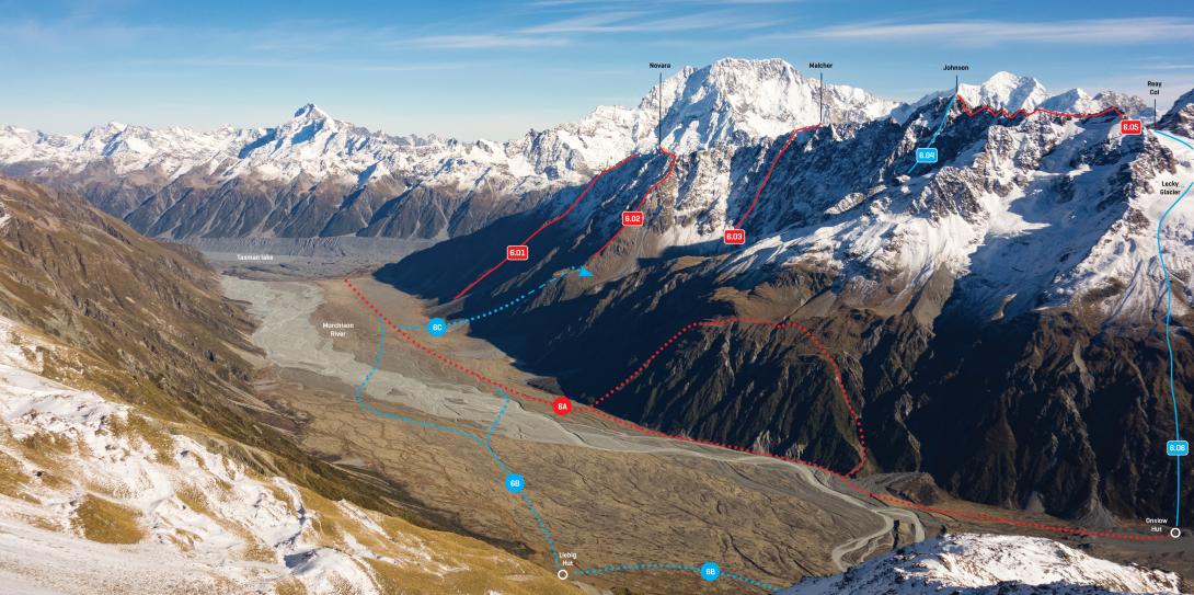
Lower Malte Brun Range and Murchison River flats, May 2017
Ball Hut Road to Murchison river flats
Route 6A on photo topo. The lower Murchison can be reached from the Ball Hut road by crossing the Tasman Glacier moraines up valley of the lake, but this is likely to be cut off within a few years as the lake grows.
There are a couple of okay spots to descend the moraine wall just up valley from Husky Flat. If you don’t like the look of those, go a bit further to Garbage Gully (see Tasman Glacier).
The low moraine wall separating the Tasman and the Murchison is straightforward to cross (2018).
Alternatively, contact Glacier Explorers to discuss getting a boat across the Tasman Lake to the upstream true left corner.
Time: 4–5 hrs to Burnett Falls
Burnett Falls to Onslow Hut
Route 6A on photo topo. To reach Onslow Hut a high traverse is usually required where the river runs hard against a large bluff, although at least one party has squeezed along the riverbank during low flows as recently as 2014.
About 1.5 km past Burnett Falls, climb onto the sloping shelf near Pt 1524m and traverse at about 1400m, then descend into the true right side of the gully that begins at about BX16 813 673. Follow the gully back down to the valley floor and continue to Onslow Hut.
Time: 4–5 hrs
Above Onslow Hut, big moraine walls make traversing the true right side of the Murchison Lake very difficult. The river usually not crossable between the lake and the large bluff below Onslow Hut.
Lower Murchison valley to Liebig Hut, Liebig Range and Murchison Glacier
Route 6B on photo topo. Once on the broad river flats of the Murchison valley, crossing to the true left is possible in low flows. Easy river flats lead to Liebig Hut.
Time: 1.5–2 hrs
The true left of the Murchison Lake can be traversed along the shoreline to reach the lower glacier. Once past the lake, try to follow dry streambeds that run along the glacier margin, and occasional scree slopes and terraces on the true left edge, rather than travelling over the moraine itself. The glacier surface is very rough in places between the Baker and Dixon Glaciers.
Lakes have formed on the true left edge of the Murchison Glacier where the stream draining Mt Ronald Adair enters the ice. It may be possible to traverse around these lakes on the hard true left edge of the valley on gravel beaches. If not, begin your morainic journey towards the true right, then grind your way up the centre of the glacier to reach the white ice near the Mannering Glacier confluence.
Time to upper glacier: 8–10 hrs
Access to the Burnett Glacier
Route 6C on photo topo. The Burnett Glacier provides access to Malcher Peak and the South Face of Mt Johnson. In the Murchison valley, begin at the stream about 800m down valley from Burnett Stream. Head up the stream to about 1200m, climb north-eastwards onto a ridge, then drop down a steep scree slope to reach Burnett Stream at about 1300m. Boulder hop up the stream to the upper basin, and gain the base of the Burnett Glacier on the true right (grade I, 2).
Shelter
Liebig Hut
~1000m, grid ref: BX16 830 658
Owned and operated by AMCNP. It has six bunks, blankets, a radio, and some kitchen equipment.
Onslow Hut
~1040m, grid ref: BX16 827 680
A small 6 bunk hut owned by the NZ Deerstalkers Association. Few facilities and there is no radio. This hut is sometimes referred to as Steffan Memorial Hut (926-296).