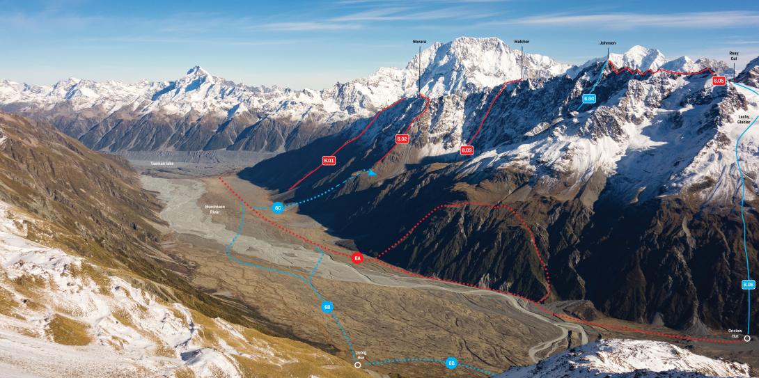
Lower Malte Brun Range and Murchison River flats, May 2017
Access to the Reay valley is currently straightforward (February 2015). Walk up the Tasman Glacier then ascend a prominent, rightwards-leaning moraine ledge on the true right of the valley entrance (the true left looks impenetrable). Once in the valley, sidle upwards on the true right to the confluence of the Reay and Walpole Streams where small campsites among snowgrass can be found. From Ball Shelter to the confluence of the Reay and Walpole Streams takes about 6 hours.
Above the Murchison valley, access to the terraces beneath Novara Peak and Mt Johnson can be found up the slopes beside the Burnett Glacier. Between the Burnett and Lecky glaciers lie tussock basins with good campsites, but there are steep walls leading from these terraces down to the river.
Routes
| Reference | Title | Grade | Length | Pro | Quality | Alert | Operations |
|---|---|---|---|---|---|---|---|
| 6.05 | 6.05North East Ridge, II,3+,13 | II,3+,13 | 0m | ||||
|
An adventurous climb. From Reay Col, traverse a 2km ridge of jumbled rock with steps becoming increasingly harder. From a sharp notch just north of the summit, ascend a final face of three pitches (crux) to the summit.
|
|||||||
| 5.133 | 5.133North West Ridge, II,2+ | II,2+ | 0m | ||||
|
This ridge begins at Dorothy Col, east of Pt 2493m. Get to the col either (i) up a moderately steep couloir from the Reay valley, or (ii) via the Dorothy Glacier (see Haupapa Tasman Glacier for access details). From the col, follow the pleasant rock ridge to the summit. First ascent unknown.
|
|||||||
| 5.134 | 5.134West Face, III,2 | III,2 | 0m | ||||
|
Climb to the head of Dorothy Stream, but before the top of the Dorothy Glacier is reached, turn right and head straight up good, fairly easy rock to the summit.
|
|||||||
| South West Ridge, II,2 | II,2 | 0m | |||||
|
Climb to ridge between Mt Malcher and Mt Johnson, then along the undulating ridge to the summit. First ascent unknown.
|
|||||||
| 6.04 | 6.04South East Face, II,4 | II,4 | 0m | ||||
|
From the Burnett Glacier, ascend the prominent rock rib leading to the summit.
|
|||||||
Just added "So Called Arthur King" on one of the red rock pillars of the lower Northwest Ridge of Johnson above the Reay Valley. Plenty more scope for new routes on the other pillars.