The Callery River catchment culminates around the Burton and Spencer Glacier systems on the remote north and west flanks of Mt Elie De Beaumont. The Spencer and Burton Glaciers were explored in 1899 by Peter Graham, Charlie Stoner, Ebenezer Teichelmann and Arthur Woodham.
Approaches from the West Coast are long and wild. The Franz Josef nèvé or the upper Tasman Glacier provide the quickest approaches, but are still fairly committing and difficult – especially in late summer.
The nearest landing sites are the Geikie Snowfield, Centennial Hut, the Middleton Snowfield, and the upper Tasman Glacier. Helicopter access is also possible to the Price Range.

Franz Josef névé to Spencer Glacier
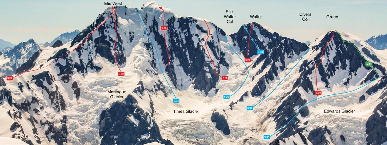
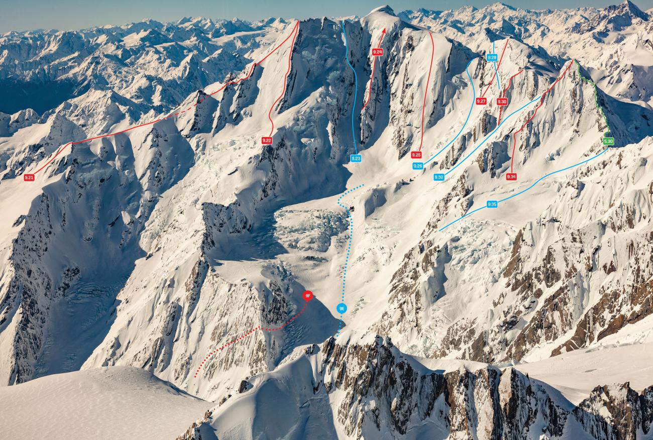
Route 9A, grade II, 2: The best winter-to-spring access between the Geikie Snowfield and the lower Spencer Glacier, when crevasses are well filled, is the upper Spencer Glacier itself, beginning at Spencer Saddle 1km north-east of Matenga Peak. The Corry Glacier is incorrectly labelled on the Topo50 maps – it flows into the Spencer Glacier at 2000m.
By early summer the Spencer icefall is usually too broken, and other options are needed.
Route 9B, grade II, 2+: The rock rib separating the Styx and Spencer Glaciers has been descended all the way to the valley floor, but still requires favourable crevasse conditions at the Spencer-Times junction.
DCF Feb 2021: “From the knoll at BX16 793 811 follow a snow ridge down (SE), avoiding the crevasses with a short detour to the east and north onto the eastern side of the Styx. After dropping 100m head SE onto a solid rock buttress with good ledges which takes you quickly to the Spencer glacier. The lower section can be exposed to icefall, but most of the time you can choose a sheltered route, and travel is easy. This route is recommended over the other alternatives above which are both subject to a high level of rockfall.”
Route 9C, grade II, 2+ When conditions are slightly more broken, from the top of the Styx or Spencer Glaciers, find a route down to the 1740m shoulder between the Styx and the Cerberus Glaciers, then descend a prominent gully (Cox’s Couloir) to the lower Cerberus. From the lower Cerberus Glacier, some parties have crossed the rock spur on the true left around 1500m to reach scree slopes to the north, which can be descended to the Spencer Glacier at 1300m. Other parties have found descending right off the bottom of the Cerberus Glacier onto the Spencer Glacier to work, if there's enough avalanche debris on the valley floor to cover the lower blufts.
This was the first route to access the Spencer directly from the Franz Josef névé, by D A Carty, Jack Cox and G Somerville in December 1936.
Route 9D, grade Ill, 2+: The lower Cerberus can also be reached by descending the full Cerberus Glacier, but that is steep and subject to almost constant rockfall. At least one party has used the spur on the true left in an attempt to minimise this risk, but the quality of the rock is awful.
Upper Tasman Glacier to Times and Spencer Glaciers
Divers Col (route 9.32) or the Elie-Walter Col (route 9.26) provide the best access from the Tasman Glacier to the Times Glacier. These are moderately steep snow routes and can be badly crevassed, especially in late summer.
Route 9E, grade Il,1+ The best route through the lower Times icefall is via the outside (true left) edge all the way to the junction with the Spencer Glacier. This is practical during spring, usually until November, but has resulted in difficulty for several parties during summer.
Time: From Tasman Saddle Hut to the Times Glacier, 4-5 hours
Route 9F, grade Il, 2+: If the majority of the Times icefall is broken, but the upper true right of the icefall can be negotiated, a diagonal ledge on the slabs to the north may be used (the Carty Ledge) to bypass the remainder of the icefall. The bottom of the ledge begins on the edge of snow/scree slopes at BX16 809 819. The upper end of the ledge finishes on the spur on the true right of the Times Glacier at about 1650m. The full length of the Montague Glacier has also been negotiated in early summer during a good snow season
Almer Hut to Spencer Glacier via the Baird Range
Route 9G, grade II, 2: A handful of parties have travelled from Almer Hut to Spencer Rock via the Baird Range and lower Drummond Ridge – an interesting cross country route requiring good navigation skills.
Begin near Thelma Peak and descend to a broad snow/shingle basin at 1720m, then turn east and descend the stream draining the basin to a level stream junction at about 1510m. From there, pick a route over the next spur east and descend to the stream draining the lake beneath the Spa Glacier. Climb and traverse east to eventually reach the lower section of Drummond Ridge, and follow this down to the Spencer rock bivvy. The lower part of the ridge skirts around some large slips and involves scrubby travel.
There are no known accounts of parties descending all of Drummond Ridge, but a descent beginning at the 2360m shoulder north-west of Drummond appears feasible.
Time: Allow a very long day from Almer Hut to the Spencer rock bivvy
Travel between the Spencer and Burton Glaciers and upper Callery valley
Route 9H, grade I, 1: To reach the Burton Glacier from the upper Callery River, ascend the prominent gravel gully 500m north-east of Pt 1123m up to a huge boulder at 1300m, then sidle above the scrub to the ridge above Pt 1123m. Descend from about 1300m on the ridge directly to the glacier.
Route 9I, grade I, 1+: To access the lower Spencer Glacier from the lower Burton Glacier, climb onto the Burton Ridge via the spur that drops into the Burton just above its terminus, descend the ridge to about 1360m, then turn left and descend a shingle slide that enters the Spencer valley at approximately BX16 796 860.
Callery River
Some history. A gold digger’s track used to exist along the side of the Sugarloaf above the true left bank of the Callery, descending to the river at Big Beach, roughly opposite the stream draining Mt Burster. The original route had 11 ladders, and a wire bridge over the river at Big Beach. These are probably long gone, but the old route can apparently still be followed with care.
Cross the river at Big Beach (this would be no laughing matter), then either climb up to Mt Burster and follow the Burster Range, or continue sidling upvalley through big gullies and thick scrub for another two days to reach the Spencer junction. The New Zealand Alpine Journal (1961, pages 143–144) has more information on where the old Callery track went.
Shelter
There are no huts in the Callery.
The Spencer Rock Bivouac sits among several moraine boulders about 100m above the river, a little higher than marked on the map, and reportedly provides good shelter from all directions.
There are two rocks on the true left terrace of the Callery about 1km above the Burton junction, which have been used for shelter by several parties, the largest of which was “very cosy for four”. They are about 100m above the river and 400m downstream of a prominent moraine mound.
More recent visItors have noted that the rocks are subject to flooding and infilling with gravel, and have found better rocks in the moraine wall up near the Callery Lake, e.g. The Monastery. The current condition of these rocks is unknown.
Images