The Grand Plateau drains the eastern slopes of the five highest peaks in Aotearoa. It is the country's most popular high alpine climbing area in spring and summer. Long, demanding snow and ice climbs requiring good fitness are the norm, but there are also some shorter rock and mixed routes.
Map
Tasman valley road to Ball Hut
The route between the Blue Lakes carpark at the end of the Tasman valley road and Ball Hut is well marked with poles and cairns. Check with the Aoraki Mt Cook Visitor Centre for up-to-date information.
Between Blue Lakes carpark and Ball Hut: 2 hours
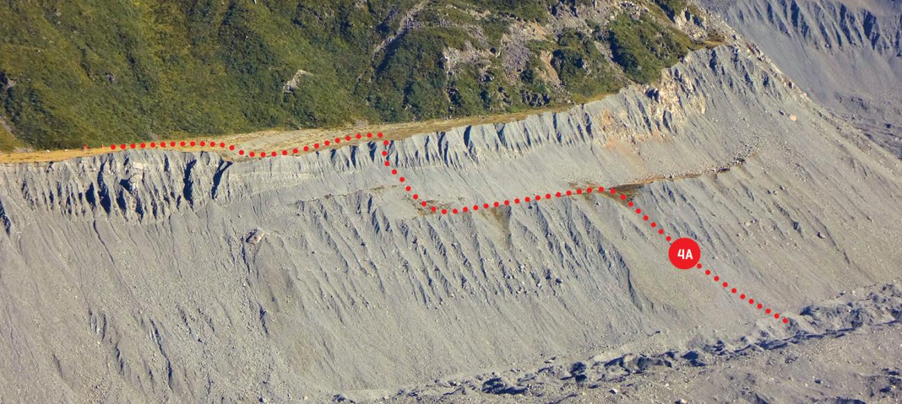
Access from Ball Shelter to the lower Haupapa Tasman Glacier and Ball Glacier
Route 4A on topo, grade II, 1+
To reach the Tasman Glacier, continue on the track past Ball Hut for about 200m, until you reach a point where a large section from the edge of the terrace has been eroded into a gut in the moraine wall below (i.e. a huge bite has been taken out of the terrace edge). Start your descent here, dropping 100m down this gut onto a lower grassy terrace. The shape of the moraine wall changes every few years due to erosion, but this general area is likely to offer the best route for some time (2018).
The intermediate terrace has remnants of an old track – follow this north until an obvious depression on the edge of the terrace. Descend from here another 150m down moraine to reach Garbage Gully – the trough running along the edge of the Tasman Glacier. The descent is on loose rock, but as at 2018 was not difficult. When travelling in the other direction, aim for a prominent streak of large boulders running up the lower moraine wall to the obvious depression on the intermediate terrace. Once on the intermediate terrace head south, then climb past the northern edge of an even smaller collapsed terrace to reach the upper terrace.
Travelling over the moraine-covered Tasman Glacier is like a game of snakes and ladders. No matter which way you go, you will be forced to ascend and descend several mounds in order to bypass large holes and icy slopes. Scope out the best way to go when on the intermediate terrace, where you still have a view. Memorising key features such as distinctive large boulders will help with routefinding. If heading for Haast Ridge or beyond, it's generally worth heading across to somewhere in the eastern half of the Tasman Glacier to make progress upvalley – the surface is slightly smoother there.
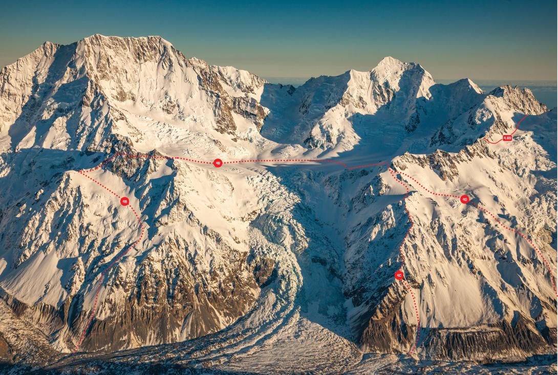
Access to Grand Plateau via Cinerama Col
Route 4B on topo, grade II, 2
This route provides the fastest foot access in and out of the Grand Plateau, but beware of soft snow conditions around the Boys Glacier, especially in the afternoon.
From the Tasman, aim for the base of the scree/moraine slope just up valley of the Ball Glacier confluence, about 100–200m north of the stream marked on the topomap. Pick a line through the steepened section 150m above the glacier, then grind up scree slopes to reach a light track on the spur on the upper left (west) edge of the scree. Head right (north) along a bench at about 1500m, with a waterfall now on your left, then turn left (west) to climb scree/boulders/slabs leading to the true left edge of the lower Boys Glacier. Ascend to the ridge at the top of the glacier (Boys Col), pick a line through the crevasses onto the upper Caroline Glacier, then ascend 150m to Cinerama Col.
To reach Plateau Hut, descend north to about 2150m, then turn left to begin a long right-tending arc past the toe of the Linda Glacier to avoid the crevasses above the Hochstetter Icefall.
In reverse, from Cinerama Col, drop 150m down the Caroline Glacier, skirting left under the Anzac Peaks, to gain the ridgeline above the Boys Glacier (Boys Col). Descend the Boys, tending left to eventually meet scree and boulder slopes. Follow the scree/boulders down and traverse rightward along a bench at 1500m (a small waterfall is now on your right). A vague track leads down a small lightly vegetated spur to the large scree slopes below that drain all the way to the Tasman/Ball Glacier confluence. There is a steeper section 150m above the glacier where care should be taken to avoid the steepest gullies.
A seldom-used route, which requires good snow cover, also exists from the Boys Glacier around the eastern side of the Anzac Peaks and up the slopes next to the Hochstetter Icefall.
From Ball Shelter to Cinerama Col: 7–9 hrs
From Cinerama Col to Ball Shelter: 5–7 hrs
Between Cinerama Col and Plateau Hut: 1–1.5 hrs
Access to Grand Plateau via Haast Ridge
Route 4C on topo, grade II, 2
Haast Ridge is on the northern side of the Hochstetter Icefall.
Gain the base of the ridge wherever a reasonable break can be found in the moraine wall, usually further up the glacier than at the toe of the ridge. Ascend towards the ridge, where remnants of an old track may be found. The ridge narrows and steepens just before it reaches Haast Hut. Above the hut, continue up the ridge and across a large snowfield on the Hochstetter Icefall side of the ridge. Ascend this snowfield to reach Glacier Dome, then descend to Plateau Hut. If schrunds prove difficult near the top, use rock slopes further right, or traverse at about 2240m on the south side of Glacier Dome, below the now rounded off icecliffs, and across to Plateau Hut.
From Ball Shelter to Haast Hut: 8–10 hrs
From Haast Hut to Plateau Hut: 2–3 hrs
From Plateau Hut to Ball Shelter via Haast Hut: 9–11 hrs
Access to Grand Plateau via the Freshfield Glacier
Route 4D on topo, grade II, 2
This is not often used as an approach, as it takes a similar length of time to Haast Ridge. However, there is less loose rock, and it can be a fast descent route with good snow/crevasse conditions. The following is a descent description.
From the upper Haast Ridge, pick a line across the top of the Freshfield Glacier between 1800m and 2100m, then descend the true left edge of the Freshfield Glacier or the spur separating the Freshfield and Haast Glaciers. Below the snowline, pick a route down the moraine to the Tasman Glacier and follow down to Garbage Gully and Ball Shelter.
From Plateau Hut to Ball Shelter via the Freshfield Glacier: 7–9 hrs
Air access
There is a helicopter landing site 50m north of Plateau Hut and a ski plan landing strip on the Grand Plateau near Mt Dixon, 10–20 mins from Plateau Hut.
Shelter
- Haast Hut: Altitude 1980m, grid ref: BX16 736 707. A now dilapidated nine-bunk hut with a VHF radio and a beautiful view, built on the site of the old King Memorial Hut and near the historic Haast Ridge bivouac, from which many early ascents of Aoraki / Mt Cook were made. Plateau Hut was built to replace Haast Hut and subsequently this hut is no longer maintained. It fills with snow every winter but still provides basic shelter in an historic place.
- Plateau Hut: Altitude 2210m, grid ref: BX16 726 705. A modern, four-100m, 33 bunk hut with a VHF radio and solar lights. In December and early January the hut may be full, so check with the AMCNP Visitor Centre when you sign in to see if there's likely to be space.
Aerial view of the Grand Plateau from the east, August 2016
Images