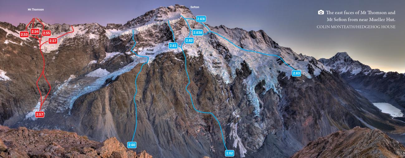
| 2.59 |
2.59Frind’s Route, IV,2+ |
IV,2+ |
0m |
|
|
|
|
|
A pioneering first ascent, now rarely undertaken because the Copland valley provides much easier access to the west side of Sefton.
The route begins from the Frind-Mueller confluence. From the true right edge of the lower Frind Glacier, head up a gully onto a rock rib north of the Ngaroimata Falls, gaining height and tending right to reach the frequently broken Donne Glacier. Ascend northwards across the glacier under Sharks Teeth to reach Brunner Col (grade IV, 3 to the col). The Donne Glacier has retreated considerably in recent years, and by midsummer most of this route is on glacier-worn rock.
Cross Brunner Col and drop onto the west side (the given technical grade of 2+ is from Brunner Col). Exposed and avalanche prone slopes under Brunner give access to the Douglas névé and the west ridge. Complicated crevasses can make crossing the névé time consuming in late summer. The final 400m to the summit is on moderately steep snow, which can be icy.
- P1
- Alpine (Commitment)
IV
- Alpine (Technical)
2+
|
| 15.13 |
15.13South Ridge Direct, V,4+ |
V,4+ |
0m |
|
|
|
|
|
This jaw-dropping skyline ridge is clearly visible from Aoraki Mt Cook village and deserves more attention as it provides an exhilaratingly exposed and challenging climb, staying on the crest all the way.
From the gap between Brunner and Sefton ascend a prominent rock step (crux) and head on up a blocky rock ridge and then a snow arête to reach Pt 3048m. Descend to a small col, climb a steep rock buttress, follow another snow arête, and up a final small rock step to the south summit and main summit.
It has been climbed only once, from Harpers Rock via Mt Stephen and Mt Brunner. The ridge could be reached from the Mueller Glacier via Brunner Col.
- P1
- Alpine (Commitment)
V
- Alpine (Technical)
4+
|
| 2.69 |
2.69North East Ridge, VI,3+ |
VI,3+ |
0m |
|
|
|
|
|
A bold route used on the first ascent of Sefton. From Sefton Biv (see Hooker Glacier for access) head up the rib behind the bivvy to where a broad bench runs across the top of the Huddleston Glacier. Negotiate your way into the upper Huddleston and continue up to access the Main Divide near Tuckett Col.
From Tuckett Col, ascend three prominent steps in the ridge to the summit. The upper step can be avoided by traversing to the right across a snow shelf to gain the upper west ridge (but then you’d be avoiding the best climbing). The rock is appallingly loose in the lower sections but improves dramatically towards the top. In 1924, Frank Milne and Harold Porter ascended and descended the ridge in four hours and reported that the upper step provided terrific rock climbing. The ridge is now rarely climbed due to a lack of enthusiasm for rotten rock.
- P1
- Alpine (Commitment)
VI
- Alpine (Technical)
3+
|
| |
North Ridge, V,3+,10 |
V,3+,10 |
2400m |
|
|
|
|
|
A magnificent climb involving 2400m of height gain from Douglas Rock Hut.
From the hut, travel 20-30min up the Copland track, then climb scree and avalanche debris nest to the Jasper Glacier Stream. Ascend the slabs true right of the stream (don't drift true left on the slabs or you'll get dizzy), which merge into easier angled scree at about 1600m (bivy sites possible before the ridge proper), and then gain the crest of the north ridge. Above here are three prominent rock buttresses, which are generally broad, with several route possibilities. The rock 'isn't bad'. The climbing mostly involves exposed scrambling with some short steps. The true ridge offers the easiest climbing through the buttresses with difficulties often overcome on the east side. Most parties appreciate using a rope, in at least one location. (An alpine rack of 5 nuts and 3-4 cams is often sufficient with good route finding).
Above the buttress, the ridge flattens out (another good bivy site) before merging into a glacial bulge. There is sometimes an icecliff here. Above the icecliffs, ascend a vague snow rib to reach a shelf just below the summit. Follow your nose to the top.
Confidence in climbing un-roped on exposed ground for the majority of this route is required. It is too long to pitch the whole route. The FA party completed the route within a day return to Douglas rock. It has more recently been completed in two days from the road end.
Beware - tales of epic retreats abound, including rapping off the leashes of ice-axes when getting low on gear to leave behind.
Descent is usually via Welcome Pass to Scott Creek or Bluewater route. (Scott Creek may be a preferable descent if you can find the single bolt rappels).
- P1
-
10
- Alpine (Commitment)
V
- Alpine (Technical)
3+
-
2400m
|
| |
Scott Creek/West Ridge, 2+ |
2+ |
0m |
|
|
|
|
The West Ridge of Mt Sefton from the Douglas Névé is a relatively straight forward 500m climb and is commonly used as a descent route. To reach the névé from the Copland Valley, the best route lies up Scott Creek. Surmount the waterfall on the western side (true L) using vegetated ledges and follow the creek, up and up, trending left. Beyond the bushline a rounded spur on the left can be gained (there are cairn-marked bivvy rocks and a stream in a small vegetated valley just north of the rounded spur) which ascends to a steeper craggy section followed by snowbasins. These in turn lead onto the ridge separating the Scott and Tekano Glaciers. Cross the Tekano Névé (watch for wet snow!) and ascend to Welcome Pass (2390m). From here follow the Sierra Range to where the West Ridge begins. Alternatively, from Welcome Pass use the Douglas Névé to access the West Ridge where it steepens. Beware of mist. Bivvying on Welcome Pass makes the summit day easier.
|
| |
Bluewater Route to Welcome Pass |
|
|
|
|
|
|
|
This is currently the recommended route to Welcome Pass, as it avoids the
waterfalls of the Scott Creek Route and involves a pleasant variety of bush,
tussock, rock, and snow travel. A route has been cut and marked all the way
from Scott Creek to the bushline. It was easy to follow in early 2016, and has been newly recut and marked with white permalat markers with a red strip in the summer of 2022/23. (A pair of loppers is left in the bush at the top end if more bush cutting is required).
Care should be taken to find the beginning of the route. It begins on a
bush-covered terrace 20m above Scott Creek on the true right bank, at about
580m, where a small stream (shown on the topomap) flows across the terrace.
This is referred to here as ‘Point A’ and is roughly located at about
BX15 563 631. The stream enters Scott Creek on the true right below a massive, moss-covered boulder. Depending on conditions, it might be possible to follow the creek up to Point A.
Access to Point A from the Scott Creek bed varies seasonally due to massive
avalanches in winter and spring that modify the shape of the creek bed and
its high, steep bank. The marked route begins from a small open
terrace 20m further upstream at about 600m – two cairns mark the route out of Scott Creek and onto the terrace. Permalat markers start on the upper end of the terrace, and a large white permalat X marks the start of the track at the top of the terrace. From there the track loops back on itself and goes back down to Point A. In summer 2022 the track is very well marked in both directions, freshly cut, and easily identifiable.
From Point A, on the true right of the side stream, the route climbs steeply,
veering away from the stream with increasing height. Stick to the marked
route. Good travel up through rata/podocarp forest, and then mountain
neinei/dracophyllum forest leads to the bushline at 1080m. At 1140m,
there’s a two-minute detour to a spectacular viewpoint over the Bluewater
basin. The marked route continues to the top of the scrub at 1300m with warratahs, and then cairns that follow up the obvious slide that goes straight to the bottom of the cliffs of point 1800.
Follow animal trails along the base
of the prominent cliffs. This leads to the final basin below the saddle
between Pt 1800m and Pt 1784m (Bluewater Saddle), which is reached via gravel
slopes and rock ledges.
From Bluewater Saddle, drop 20m on the Tekano side, and then traverse and
climb back onto the ridge south of Pt 1800m. Follow this ridge south for
about one kilometre, and then ascend on a rising traverse across the Tekano
névé – watch for crevasses and soft afternoon snow – to Welcome Pass.
In the reverse direction: when descending below the bluffs, if you overshoot
the large boulder at 1300m [BX15 573 622], you should encounter an old slip
with regenerating scrub which leads into the stream marked on the map
beginning at about BX15 572 624. This can be followed down to about 860m,
where there is a short section of pink tape that leads away from the stream
back to the main Bluewater Route. There is a small flat in this stream at
about 900m which is large enough for one tent.
The Bluewater Route through the bush has been used by hunters for some time.
The first recorded use of the full route as a descent from Welcome Pass was
by Danilo Hegg and George O’Sullivan, Jan 2010. The first recorded climb of
Mt Sefton using this route was by Nina Dickerhof and James Thornton in Nov
2015
|