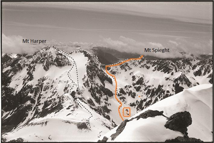
Mt Speight was first climbed by Roger Chester, R E McInnes and H C Wickett in April 1930. Mt Speight Buttress has some of the best quality rock in the Arthurs Pass National Park.
From the Waimakariri River access via Harper Creek. Follow Harper creek until reaching and impassable waterfall. Turn left up steep snow (or scree) gulley, be mindful of avalanche and rockfall. Trending left towards the top of the gulley. Upon reaching the ridge, drop onto the southern side and sidle towards Mt Speight. Allow 6-8 hours from Klondyke Corner.
Places
| Type | Name | Alert |
|---|---|---|
| Face | Speight Buttress |
Routes
| Reference | Title | Grade | Length | Pro | Quality | Alert | Operations |
|---|---|---|---|---|---|---|---|
| Camp Mum Couloir, 4 | 4 | 150m | |||||
|
A 150m long couloir that leads up to the North East Ridge. The first (crux)
|
|||||||
| North East Ridge, IV,4,12 | IV,4,12 | 0m | |||||
|
This route has had several ascents over the past decade; though its first
|
|||||||
| Normal Route, 1 | 1 | 0m | |||||
|
Usually climbed from the old Greenlaw Hut site, by ascending the spur between
|
|||||||
| North Ridge from Harper Creek, II,2+ | II,2+ | 0m | |||||
|
Gain the large snowfield east of the saddle between Mt Speight and Mt Harper,
|
|||||||
| From Headwaters of Burnett Stream, 1 | 1 | 0m | |||||
From the head-waters of Burnet Stream. Ascend the scree/snow-slope north of the creek that drains Speight’s West Face. A steep pitch joins the permanent snow-slope (beware of bergschrunds) that leads to the prominent col north of Mt Speight. Follow the ridge to the summit. |
|||||||
| North Ridge from Burnett Stream | 0m | ||||||
From the head of Burnett Stream climb scree and rock to a small glacier that leads to the North Ridge of Mt Speight. Scramble along loose rock to the summit. |
|||||||
| CD | CDSouth-East Face, 3+,WI2 | 3+,WI2 | 350m | ||||
|
The lookers left gully of the two central gullies. Tops out directly to the
|
|||||||
Images
Yvonne Cook and Geoff Spearpoint, in association with the Canterbury Mountaineering Club

