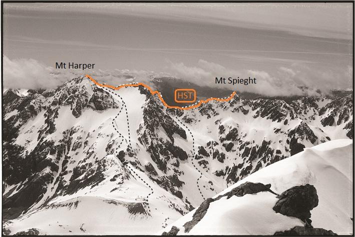
This traverse can be completed by a fit party based at Barker Hut, via White
Col and Mt Harper’s South West Ridge. The very craggy Harper-Speight ridge
is then followed: this traverse involves a steep buttress descent to the col
at the head of the Speight snowfield. An alternative route, which avoids the
buttress, descends the eastern snowfield of Harper and joins the usual route
up the Speight snowfields.
A traverse of these three peaks starts at Echo Col. The traverse can be
continued to the Mottram Peaks and a scree descent made into the Waimakariri
Valley.
A grand traverse of the Black Range, including ascents of Mts Harper,
Speight, Damfool, Cow Peak and Mt Gizeh, and descending Hut Spur back to
Highway 73, is an experience that a light, efficient party could tackle given
four consecutive good-weather days. Good camp sites (with water or snow melt)
can be found just below Greenlaw Col, Echo Col, near the tarns above Jordan
Creek, and finally at Bealey Spur Hut. The ridge traverse tends to be quite
exposed in places, combined with rotten rock, however in most cases obstacles
can be avoided on snow slopes below the ridge lines.
This area is popular and easily accessed terrain for ski touring and telemarking. There is a good foot track that leads from the car park at the Bealey Spur settlement (680m). Skis can often be fitted at the tarns at about 1000m elevation after about an hour’s walk. The Bealey Spur Hut (1240m) is reached within another hour or so.
Point 1545 above the hut provides reasonably good runs, though stay away from its southern slopes, as these dive off cliffs into Power Stream.
It is possible to continue as far as Jordan Saddle, and the tarns at the head of Jordan Stream. There are steep pinches in this route and parties should be aware of avalanche and cornice danger.
There is also good skiing terrain on the east side of point 1875 (headwaters of Power Stream) and the south side of point 1907. Ski mountaineering parties, travelling on ski and foot, and using ice axe and crampon, may traverse the whole of the Black Range as far as Lagoon Saddle, and exit on foot to Cora Lynn.
In seasons when the snow cover is good there is a surprising amount of good skiing to be had in the Black Range and across the northern Craigieburn Range via Cass Saddle.
The full through trip takes anything from 5 hours upwards – depending upon how many of the side basins are skied.
The route is best started from the Main West Coast highway at the gate - map ref 2400615E, 5796335N (NZMG Sheet K34) – before you cross Broad Stream.
Head up MacKay Stream and find the old deer track on the true right. You would usually expect to reach the snow line in about an hour. From there you can skin up the basin to the Black Range at between either of the two points marked at 1854.
The general route follows the ridge heading South with plenty of opportunities to ski a number of basins on either side of the ridge. There is also some good skiing to be had by heading North East towards Mt Misery.
From the high point marked at 1912 overlooking Cass Saddle there is a choice of several routes down to Cass Saddle.
Follow the slopes on the Cass side of the ridge.
Cross into the basin at the head of Hamilton Creek – this requires either a long traverse back to the saddle or a climb back up to the ridge.
From Cass Saddle skin up the slopes towards Mt Hamilton – about a 60 minute climb – and pick any one of the routes down to your transport.
Note: There is an avalanche risk at the head of MacKay Stream which you will need to assess. An alternative route to the ridge can be made via the first side creek on the true right which takes you up some steep screes onto the main Black Range ridge.
Alternatively from the Cora Lyn end, climb through the bush on the Lagoon Saddle track for 90 minutes to the bushline. Mt Bruce (1630m) may be accessed from there, by climbing its northern slopes. Better skiing may be found on its southern side. Further along the Cass-Lagoon track, at altitude 1150m, there are two DoC structures, a 3-4 bunk hut (Lagoon Hut) and another shelter adjacent, which could be used for accommodation if you wished to stay up there. To the west of Lagoon Saddle, NE-facing slopes lead up to the Mid Hill basins, which are also worth a tour from this base.
From the Craigieburn end, the run down from Mt Hamilton to Cass Saddle and even across to Peak 1912 is well worth the effort. Although on a hot day the climb back up from Cass Saddle can be quite warm.
Grade 2–3