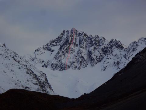
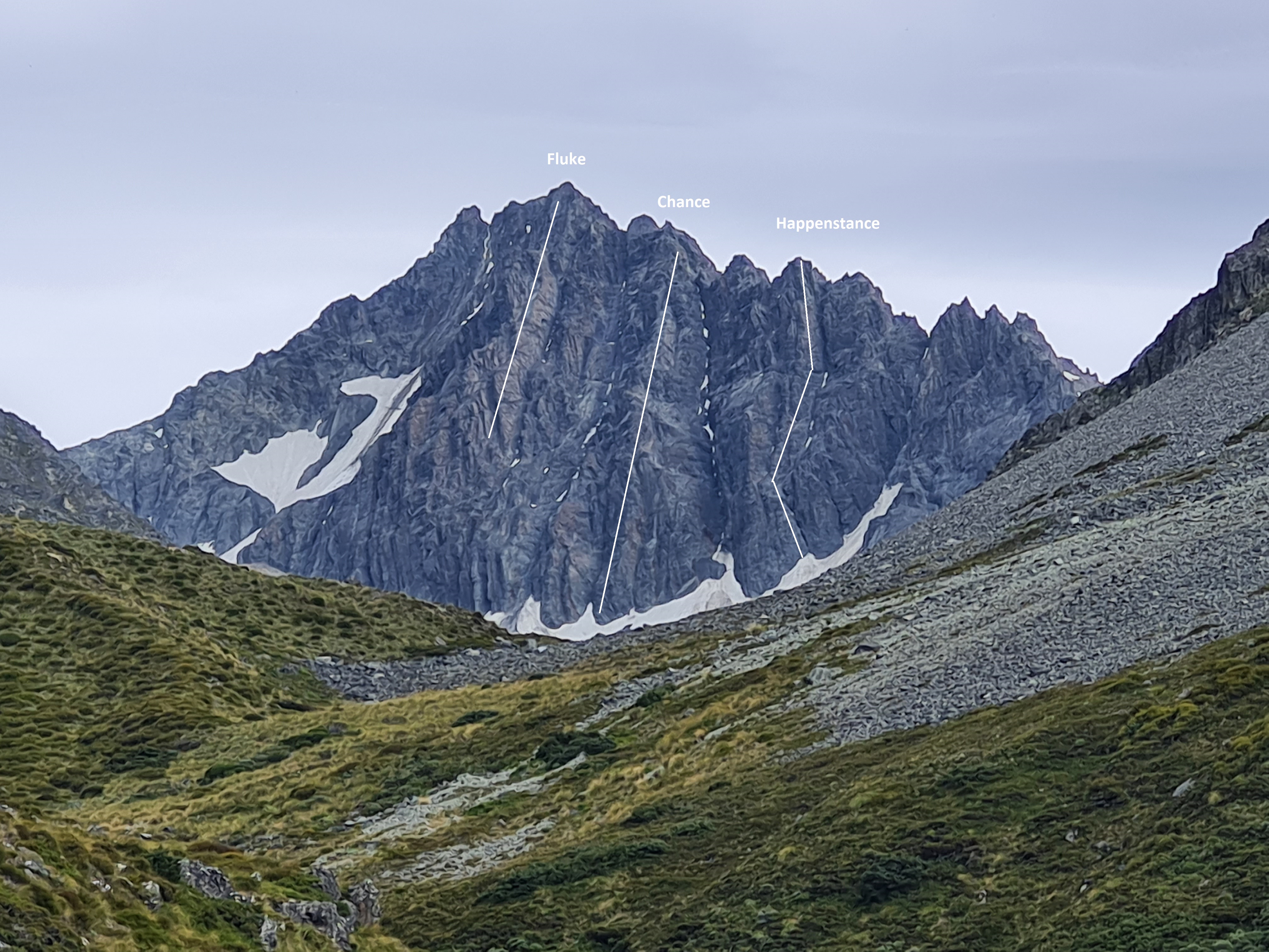
Ferintosh Peak is the most aesthetic peak in the Ben Ohau Range when viewed from the east. Close scrutiny reveals that Glentanner Peak is tucked behind and slightly right of Ferintosh Peak.
Routes
| Reference | Title | Grade | Length | Pro | Quality | Alert | Operations |
|---|---|---|---|---|---|---|---|
| South Ridge, II,2 | II,2 | 0m | |||||
|
From the head of the north branch of Whale Stream, scramble onto the Ben Ohau divide south of Ferintosh Peak, and traverse north to the summit sticking to the Dobson side of the ridge.
|
|||||||
| Fluke, IV,4,14 | IV,4,14 | 450m | |||||
|
Take the ramp on the left centre of the overhanging face, climb under a chockstone to reach easier ground, then follow the central rib on good quality rock to the summit. Some level sections en route. Descent is via the South Ridge.
|
|||||||
| Dare Route, IV,5,WI4,M4 | IV,5,WI4,M4 | 450m | |||||
|
Start up steep ice through the lower rock band, slightly right of centre, before following a vague gully system to finish just right of the crest of the main buttress.
|
|||||||
| Chance, IV,4,14 | IV,4,14 | 350m | |||||
|
Follow the next major rib right of Fluke. Scramble moraines and snow remnants up towards the base of the peak, with a few steps across Firn snow to the base of the central buttress of the rib. Climb loose blocky rock for the lower/steeper half, following weaknesses close to the crest of the rib, then on quality rock thereafter [On the lower half, much better rock and climbing could be had on the right of the arete, but at a higher grade and with minimal gear]. Above, where the angle eases and the tock improves, round the first tower on the left, and the second on the right. From the top, traverse across several towers along the ridge to the summit. On FA, 1 hr 25 for Chance, plus 25mins to summit; then descent was circuitous, made via the great ridge to Glentanner peak and down Twin Stream.
|
|||||||
| South West Face | |||||||
|
No recorded ascent, but Stewart Stream provides good access to the south-west face. |
|||||||
| IWC, 17 | 17 | 100m | 2 |
||||
|
THIS ROUTE AND ITS' SUPERIOR NEIGHBOUR (THE DORSAL FIN) HAVE BEEN MOVED TO THE WHALE STREAM SECTION. SEE WHALE STREAM FOR UP-TO-DATE DESCRIPTIONS. On the true left side of the North Branch of Whale Stream, halfway between the forks and Ferintosh Peak, is a striking fin of rock, several pitches high, that eases into a prominent spur above. IWC climbs 2 pitches up the low angle lower fin, then 4 pitches in the crack / corner systems left of the fin. A meandering trad route, climbed as an enjoyable access route onto the buttress. The central feature is a huge right-facing corner. Mainly solid rock, would benefit from some further cleaning of vegetation on the crux pitch.
Run it out up p1 & 2; easy climbing on solid rock past widely spaced bolt and gear placements up the crest of the striking low-angle arete. This is the obvious, aesthetic access to the buttress above.
Run it out up p1 & 2; easy climbing on solid rock past widely spaced bolt and gear placements up the crest of the striking low-angle arete. This is the obvious, aesthetic access to the buttress above.
From the left side of the ledge below the upper fin: climb up and left, around the left side of a large roof, then back right to belay below the enormous right-facing corner. Some loose rock. A harder, more direct bolted pitch now exists directly through the overlaps (unclimbed - 2022 summer project) - this pitch ends some meters right of the the P4 corner - an easy walk/traverse away, perhaps best to bump belay across if rope drag promises to be an issue.
Up the corner crack directly to a cramped belay in a bomb-bay alcove below a huge roof. Great climbing but needs further cleaning of vegetation.
Left out of the cave and through the roof via a crack/groove, then trend back right across the slabs (cracks) to gain the large corner against the fin. Follow this up to belay below a final steep wall.
Break up the steep wall on the right, dramatic features but surprisingly easy and exhilarating climbing. Belay on the narrow ridge crest above. From here, pitch across/down the ridge to a DBA where it steepens.. Rap the fin (closed project - DBAs and occasional protection bolts). 30m raps may be just adequate to get between rap stations, but no guarantees. The odd protection bolt between stations exists and may help. |
|||||||
| Happenstance, IV,4+,17 | IV,4+,17 | 300m | |||||
|
There is rockfall hazard on the lower pitches from the gully on the right, particularly if there is melting snow in the gully. Start with a pitch of 17, taking a narrow crack through a bulge shortly left of the mouth of the couloir (position the belayer away from the couloir). Crux near the bottom, and in a committing steep pull on a large overhanging block at the top. Continue up into the bottom of the gully, then weave up shallow gullies/ribs on the left until the angle kicks up. Belay here, traverse right a few meters and climb steeper rock just to the right of the arete, then a traverse pitch rightwards on loose, easy rock leads to overhangs at the base of the obvious clean wall of good red rock forming the right side of the upper third of the rib. Below below these. Start in a steep handcrack just left of a small left facing corner (or choose another; several steep cracks run through the roofs), then straight up (good rock climbing) for a couple of pitches. Continue up blockier aretes and wide cracks to the top of the pinnacle. The ridge is a windy place on a NW day; following the FA, descent was to the North (towards Twin Stream) then a long traverse below the ridge before taking loose ground back up to a col and down exposed snow slopes (avalanche terrain) back into Whale Stream. A traverse to the summit over/around the towers on the ridge should be possible and allow a different descent; ridge travel to the summit is relatively straight forward from the top of Chance.
|
|||||||

