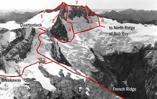
Avalanche is a very attractive mountain, especially as seen from French Ridge. It
offers a variety of routes, several of which are ‘on’ in a relatively short day from the hut or if the weather is looking doubtful.
Routes
| Reference | Title | Grade | Length | Pro | Quality | Alert | Operations |
|---|---|---|---|---|---|---|---|
| 1 | 1North Ridge, III,2 | III,2 | 0m | ||||
|
The ridge is reached from the head of the Bonar Glacier. Most parties, seeking protection from the weather, have climbed on very exposed ledges on the Kitchener side, however, the crest of the ridge or the western slabs may be more desirable in good conditions. Two prominent steps occur. The first is low on the ridge and can apparently be negotiated on either side, but the upper one is turned by ledges on the east. The ridge takes 3–4 hours from the head of the glacier or 6–7 hours from French Ridge Hut.
|
|||||||
| 2 | 2West Ridge, II,10,2 | II,10,2 | 0m | ||||
|
Climb to the Bonar via the Quarterdeck and continue up the glacier on the north side of the ridge to avoid the gendarmes of the lower section. Gain the ridge at the foot of the slabs. Although some of the rock is loose, the slabs offer pleasant climbing (approx. rock grade 10) and lead directly to the West (highest) Peak. The time necessary from the hut to the summit is usually between 4 to 6 hours.
|
|||||||
| 4 | 4From the Maud Francis Glacier, III,2 | III,2 | 0m | ||||
From the Maud Francis Glacier cross the schrund to reach the steep snow ramp leading up below but parallel to the slabs of the West Ridge. The ramp joins the summit ridge just east of the West Peak. This route has been skied. |
|||||||
| 5 | 5Maud Francis Glacier (snow lead), III,1+ | III,1+ | 0m | ||||
A less prominent, and less steep, snow lead rises from the Maud Francis Glacier almost directly below the notch of the summit ridge. The snow runs out about 30 metres below the middle peak and the climb is completed on the easy rock of the South Ridge. Late in the season this route may be almost clear of snow and may be followed on easy slabs. |
|||||||
| 6 | 6South Ridge, III,2 | III,2 | 0m | ||||
|
The South Ridge leads directly to the Middle Peak. Climb the Quarterdeck to the Bonar and descend the Flightdeck to reach the Maud Francis Glacier. The rock of the South Ridge is reached from a snow lead where the ridge begins to steepen towards the peak.
|
|||||||
| 7 | 7West to East Peak Traverse, IV,4 | IV,4 | 0m | ||||
|
The traverse of the summit ridge is a far more exacting proposition than the West Ridge. The crux of the traverse is a deep notch, which requires a very delicate descent of a 40m wall and an even more difficult climb out the other side. Kennedy and Innes took seven hours from the west to the middle peak, of which three were spent getting past the notch.
|
|||||||
