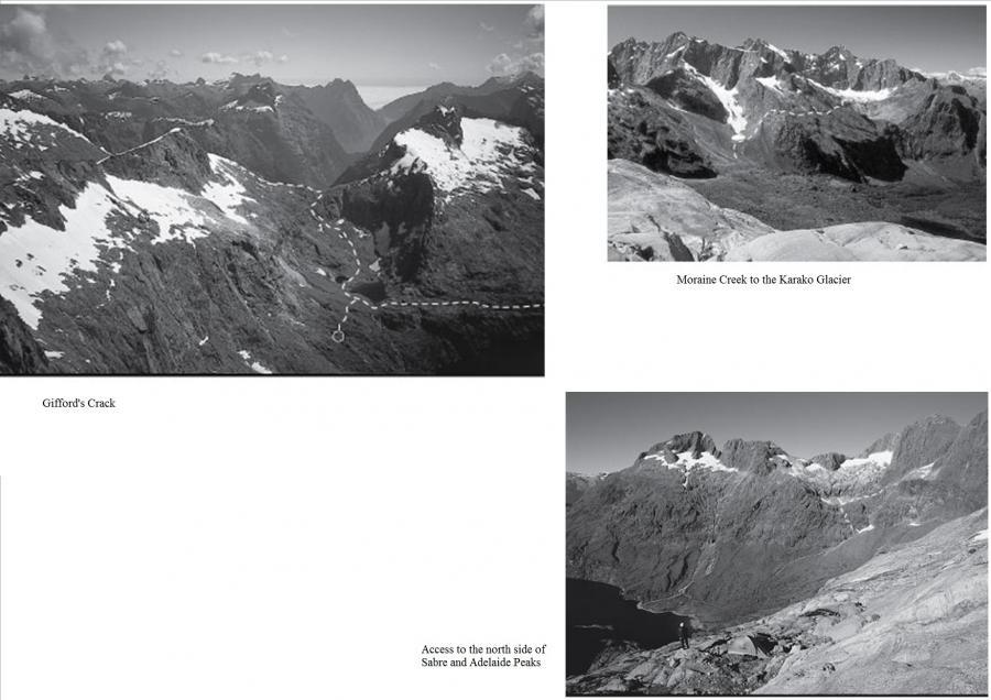
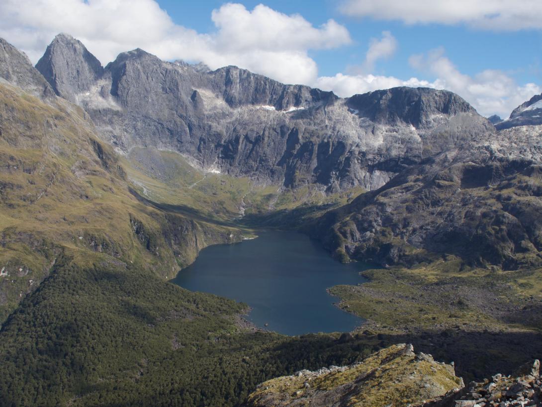
Moraine Creek was first explored by the surveyor E H Wilmot in 1883. The party climbed to the head of this spectacular and scenic valley, ascending to Adelaide Saddle which lies between the peaks of Barrier Knob and Sentinel. Later exploration of the valley by William Grave, Arthur Talbot, Alfred Grenfell and Charles Gifford culminated in an ascent of Gifford’s Crack, a steep gut which has now become the packing route into the upper Moraine Creek from the Gertrude Valley. Lake Adelaide at the head of Moraine Creek is paradise for the adventurous climber. Bivvy rocks provide complete shelter in any Fiordland weather. Dozens of cragging routes line the cirque, and the sheer walls of Sabre and Marian tower above.
Access to Lakes Adelaide and South America from the Hollyford River
From the Lower Hollyford Road cross the swing bridge over the Hollyford River and follow the track for 15 minutes to the wire bridge over Moraine Creek. The track rises steeply through thick bush to pass a rocky gully and a small rock bivvy just below the track. The track leaves the bush after two to three hours, crossing Tent Flat. Follow a stream bed on the true left towards the bluffs below Revelation, continuing up the stream through scrub and ferns to Hut Flat, the old hut site. Moraine Creek Hut was destroyed in an avalanche in the 1980s. There is a poor three-person rock bivvy just inside the bush edge on the lower side of Hut Flat near the main stream. Continue up the tussock slope above Hut Flat to a saddle at the crest of the moraine wall. (The route onto the Korako Glacier departs here, four to six hours from the road.) From the moraine wall descend to a tarn and follow the shingle valley, staying close to the slopes of Mt Apirana. Cross two bands of boulders to reach Lake Adelaide. About 100m before the lake, climb the tussock slope to a terrace which gives good travel until it is broken by a slab. Cross the slab and climb up to regain the terrace which continues to the outlet of Lake South America.
Gertrude Saddle to Lake Adelaide via Adelaide Saddle
The standard packing route from Homer Hut into the Adelaide basin crosses over Barrier Knob to Adelaide Saddle then down into the head of Moraine Creek. Although it sees many footprints each season the travel is often exposed, the terrain difficult and the rise and fall in elevation considerable. Many parties have come to grief on this route.
From Gertrude Saddle there are two possible routes to Adelaide Saddle:
- Climb up tussock and snow slopes toward the summit of Barrier Knob, exiting on the ridge to the right of the summit. Then follow a cairned route down the North Ridge of Barrier Knob.
- A shorter and more exposed route traverses high across the south-west face of Barrier Knob. Climb the tussock slopes above the saddle for 250m to a large ledge on the left. Follow the ledge past a short rock step and scree slope. Step down and across some wet slabs (take care if icy or snow covered) and up a short gut, filled with snow early season, to a notch on the skyline ridge best sighted from higher up. The track across the traverse descends slightly to the ridge above Adelaide Saddle, through a rocky col on the ridge.
The start of the traverse can be tricky in winter and early summer and the route over the top of Barrier Knob may be safer.
Descend the ridge from Barrier Knob to the lowest point of Adelaide Saddle and follow a faint track down a tussock ramp on the true right to a gully. At the base of the gully move across and over a small shoulder into the corner. This is Gifford's Crack: descend down this rocky gut to the scree above Lake South America.
An alternative to Gifford's Crack is to continue up the ridge past the saddle and over the Sentinel Shoulder, then down slabs towards the lower end of Lake Adelaide to join the ledges around the lake.
Moraine Creek to Hollyford via Gunn Basin
The col north of Adelaide Peak gives a route to the Gunn Basin and the now overgrown track down to the Hollyford Valley.
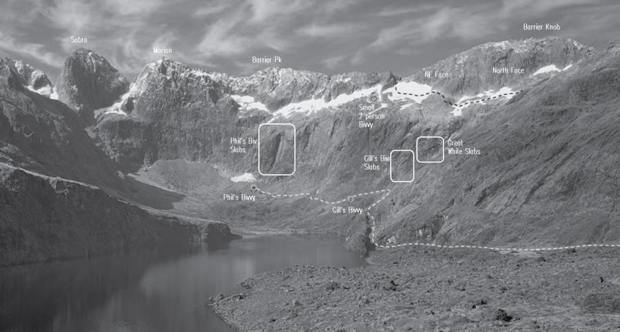
Gill’s Bivvy
From the outlet of Lake South America, Gill's Bivvy can be seen about 200m away in a cluster of large rocks and is best approached by going above the rocks and descending the far side. Mike Gill describes finding the bivvy in January 1959 and using it as a base to climb the west ridge of Sabre with Phil Houghton. They named it Lakeview Bivvy but it has been ‘Gill’s’ ever since. There are two large rocks with a great view over Lake Adelaide; the upper bivvy is larger with room for six. The bivvy can be used for climbs on the Great White Slabs and for trips from the Gertrude Valley through Moraine Creek to the Hollyford.
Phil's Bivvy
Phil's Bivvy is the most luxurious of bivvies in the Darrans with two large enclosed dry ‘rooms’ accommodating around 14 people, set in a gently sloping tussock field with a large sun deck and views across Lake Adelaide to the Central Darrans peaks. Found by Murray Judge and Bill Denz, who with Phil Herron spent the summers of 1974 and 1975 climbing routes on the north walls of Marian and Sabre directly behind the bivvy, it is now the main base for climbs in the head of the Adelaide Basin and offers good shelter in all weather. Phil's Bivvy is located high on the eastern side of the basin and is reached by traversing as high as possible across narrow terraces at the foot of the cirque wall. This route is threatened by avalanches in the early season and a lower route maybe necessary.
Routes
Images