
Garden of Allah Ice Plateau

Type

The Garden of Allah, and its continuation in the Lambert Snowfields extends for 8km. They overlap north and south of each other, and access between them is via Adams and Angel cols. Five rivers drain to the west from them and mountains on their fringes. Newton Pk at 2543m is highest in the area, followed by Mt Tyndall at 2517m and Mt Kensington at 2444m. Rock is generally greywacke grading into schist of variable quality.
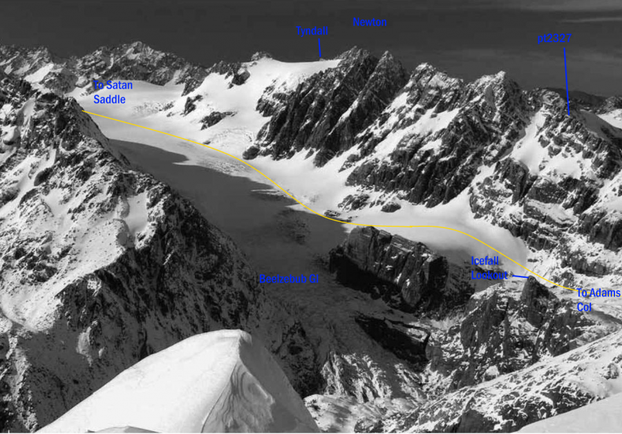
Travel on the Garden of Allah snowfield is generally straight forward, though crevassed areas reduce easy travel to obvious lines. The neve at the head, connecting easily with the Lambert over two wide saddles, is more extensive than it first appears from lower down. The Lambert neve itself remains a major snowfield, bounded by the Main Divide on one side and Mt Lambert on the other, split in the head by a ridge of reasonable greywacke rock. Travel down from Satans Saddle to pt 1967m is normally fine, but expect crevasses. The other branch, south of pt 2220m, also offers good travel and an alternative that can be linked back under the pt 2220m ridge to the Satans Saddle branch. To continue down the small icefall between 1700m and 1800m, the least crevassed slopes are over on the true right hand side of the main Lambert Glacier. Direct approaches to Lambert Col from here are normally easy. Continuing on down, the O'Neil Glacier can usually be approached from the lower Lambert below here without too much trouble, but it is seasonally variable.
The ridge north of the Garden of Allah leading up to Mt Lambert has informally been referred to as Tenzing Ridge since the 1950s. Significant ice flanks the southern slopes, particularly under Mt Lambert itself. On the northern side of this ridge, there are some significant buttresses and, in places, promising rock at the head of Aciphylla Creek. Across the Lambert Glacier, slabs lead up to Mt Stoddart. The east face of Mt Stoddart is unclimbed as far as i know, but broken rock doesnt make it a particularly attractive looking proposition
For over 70 years the area has been the focus of transalpine climbing parties, and it was an early one of these that provided the name. 'This neve area on part of the Adams Range was named the Garden of Eden', wrote John Pascoe in the 1935 New Zealand Alpine Journal (page 143) acknowledging in the The Canterbury Mountaineer 1934/1935 that AP Thomson in their party inspired the name. Routes through the area have often been as important as the climbing objectives, and this guide provides information on those routes as well as the climbing. Many of the climbs from the plateaus are relatively easy, but more challenging routes such as the buttresses on Newton Peak from the Garden of Allah exist

Image
Lat/lon
POINT (170.719643 -43.308816)
Topo50
BW17 151 024
Access

The main access to the Gardens from the east is Perth Col via the Clyde Branch of the Rangitata River. This is the easiest overall access but is dependent on Clyde River conditions. The Clyde is often uncrossable, especially in spring with snowmelt. It has usually dropped to crossable levels by late Jan or Feb. From the west, there are two main approaches to the Gardens. One is via the Wanganui Valley and Lambert Spur, sidling to the Lambert Glacier. The other is via the Perth Branch of the Whataroa River. See the Whataroa and Wanganui Valleys amongst others for those access details.

Add Place Add Route

Places

Type Name
Mountain Icefall Lookout
Pass Satan Saddle
Pass Gadarene Col
Mountain Mt Stoddart

Routes

Reference Title Grade Length Pro Quality Operations
 Hunters Hut to the Gardens via Lambert Spur
0

  • P1

In good conditions this is the best approach to the Gardens from the Westland. However, part of it, particularly sidling under Mt Lambert has significant avalanche risk when there is fresh snow. There are superb grass campsites near 1443m, and others over at a gravel flat, I35 269677. From Hunters Hut take the track out to the Lambert riverbed, follow the boulders up and cross the Lambert bridge. A good track on the true left leads across a bush terrace before climbing up a spur to pt 1148m, a rocky viewpoint in the scrub. Almost a km further, leave the scrub behind and continue through long tussock into short grass and easier going above about 1450m. Below a small tarn at about I35 264694, there is no water on the ridge. From the knob at I35 265692, to get to the saddle at I35 259681, there are two options. Either descend to the wonderful camping basin south east of pt 1443m then continue to the basin below at I35 256689 before climbing up to the saddle, or sidle across from the small col south of the knob, sidling slowly up to the tarn shown on the map then following the snow or gravel slopes beyond through to the same saddle. From that saddle, descend a snow gully south to access another saddle at I35 262675. The gravel flat about a km east offers a good campsite. (The steep bouldery creek below here has been used to descend all the way to the Lambert Head Flats, but is loose and a poor route. Bouldery falls mean descending oversteep gravel ribs in places to get down). From this gravel flat, descend the steep loose stream east to about the 1300m contour. Drop packs and find a relatively safe route through otherwise steep tussock slopes usually marked with small cairns, crossing about 3 gullies. The first gully has a gravel creek and is crossed near a big boulder. Sidle out on the far side, cross a tiny saddle at 1340m and continue on across to a small dry shingle gully just above falls and ascend right up that to a cairn at the 1500m contour I35 275673 on a rib. Beyond here lie easier ledges and basins under Mt Lambert. Continue south east down across a basin then climb up past a big prominent boulder at I35 277669 before continuing a sidling ascent to the col on the ridge just west of pt 1967. Descend to the Lambert snowfields. Both upper branches of the Lambert Glacier give access to the Garden of Allah, with a few slots around Satans Saddle itself to watch out for. The sidle under Lambert is subject to spring and winter avalanches, and is not recommended in wet or snowy conditions. Time. Hunters Hut to the basin south east of pt 1443m, 6hrs. From the basin south east of pt 1443m to the Lambert Snowfield, 6hrs.


Comments
Attribution
Yvonne Cook and Geoff Spearpoint,
in association with the Canterbury Mountaineering Club
UUID
 
554c7a9a-c666-4f3e-a03b-00a3c0cda96f