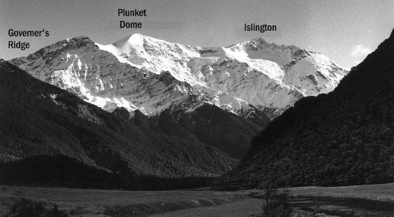
Governor’s Ridge connects Plunket Dome, Islington and Liverpool and forms the edge of the upper Dart Névé. A fantastic alpine wander can be had by traveling up to Cascade Saddle, along Governors’ Ridge and down one of the ridges above Rough Creek.
Map
Routes
| Reference | Title | Grade | Length | Pro | Quality | Alert | Operations |
|---|---|---|---|---|---|---|---|
| Governors Ridge, II,1 | II,1 | 0m | |||||
|
From the top of the Cascade Saddle track follow around and through a basin to Cascade Saddle. North of the saddle Governors Ridge is an easy, broad, but crevassed snow climb over Plunket Dome and Islington to Liverpool. From Aspiring Hut to Liverpool requires about 7 hours.
|
|||||||
| Via ridge north of Rough Creek, II,2 | II,2 | 0m | |||||
|
From Aspiring Hut cross Cascade Creek (bridged) and strike up through the bush from the top of the flats opposite the hut, to meet Rough Creek at the foot of the hill slope. Cross Rough Creek on avalanche ice to gain the scrubby ridge to the north. The ridge joins Governors’ Ridge between Plunket Dome and Islington. The main obstacle is usually a large schrund a short distance below Governors’ Ridge.
|
|||||||
| Via the ridge south of Rough Creek, II,2 | II,2 | 0m | |||||
From Rough Creek (Route 3.2) climb through the bush and scrub of the ridge immediately south of the creek. Traverse left (south) across scree about 50m above the scrub line into a gully. Cross the creek in the gully and work up through the snowgrass bluffs to the south to reach a ridge with a clear gully on either side. Climb straight up the ridge until it peters out level with the snout of a small glacier descending from Plunket Dome. An easy traverse leads across to the glacier, the south side of which is then followed up to Governors’ Ridge, about 350m above Cascade Saddle. |
|||||||