A very imposing pinnacle of rock. On many occasions it still manages to pierce the notorious West Coast cloud (something of a redeeming quality). It is by far the best climb east of Arthur’s Pass.
Map
Routes
| Reference | Title | Grade | Length | Pro | Quality | Alert | Operations |
|---|---|---|---|---|---|---|---|
| North Ridge, III,4,14 | III,4,14 | 0m | |||||
|
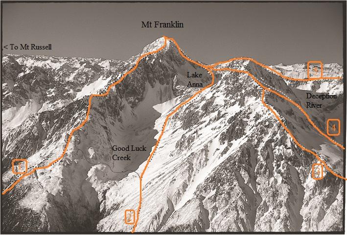
From the Good Luck Creek basin, ascend to and cross over Pt 1652m on the West Ridge, descending to the 1560m contour at the head of the unnamed stream below the northwestern slopes of Mt Franklin. From here sidle scree slopes in a northeasterly direction, aiming for the low point on the ridge between Mt Franklin and Pt 1806m. The ridge is mostly good rock scrambling (up to Grade 10) with moderate exposure to about three-quarters height. Here the ridge steepens with two 40–50m pitches of Grade 12, with one short section up to Grade 14 (although it may be possible to avoid this). The summit is a further 100m of about Grade 10 scrambling.
|
|||||||
| 1 | 1West Ridge, III,3+,13 | III,3+,13 | 0m | ||||
|
Approach from Good Luck Creek basin via the Deception River route or alternatively via the densely wooded spur that leaves the Deception River at K33 974151, on the true left of the stream that drains the Franklin-Russell escarpment. This ridge is notoriously long and loose, and has multiple gendarmes. Once committed to this route there are no escape routes, however travel tends to be fast over large sections. Considered a mid spring climb when ice clings to it. The ridge can be dangerously corniced under winter conditions, making it extremely hard to negotiate. Descend by the south ridge.
|
|||||||
| 2 | 2South Ridge, III,2 | III,2 | 0m | ||||
|
Reach the Good Luck Creek basin, and Lake Anna, by ascending the scree slide upstream of Upper Deception Hut to the scrub line and then sidling at the 1400–1500m contour into the head of the creek. Above Lake Anna, gain the col at 1890m and traverse slabby rock and shattered pinnacles. If good snow ramps exist this section can be bypassed by climbing a snow lead and short couloir further left under the South Ridge. The South Ridge rises steeply to merge with the West Ridge. An excellent route. The upper ridge can be dangerously corniced under winter conditions, making it extremely hard to negotiate.
|
|||||||
| 3 | 3South West Ridge, III,3 | III,3 | 0m | ||||
|
A long climb. From opposite Goat Pass Hut utilise the obvious deep gully and notch to gain the ridge. The initial ridge to Pt 1975m point is generally straightforward. Not far past this point a significant notch in the ridge requires a short, steep and exposed down-climb on the Deception side, and several gendarmes must be negotiated on the ridge to reach the Lake Anna col and the South Ridge.
|
|||||||
| 4 | 4South West Ridge Couloirs, III,2+ | III,2+ | 0m | ||||
|
This route can be climbed in winter to late spring by reaching the head of the Deception River from Goat Pass Hut. Scree or snow slopes head through the lower bluff to reach the steep snowfield (avalanche danger!) below Pt 1975m on the South West Ridge. In a normal season three 150m couloirs gain the South West Ridge. Continue along the South West Ridge and South Ridge to the summit. Return via Lake Anna and the Good Luck Creek basin route.
|
|||||||
| 5 | 5Mt Oates-Mt Franklin Ridge, III,3+ | III,3+ | 0m | ||||
|
This ridge is a very long journey from Goat Pass and would be better tackled from a camp near Lake Mavis. Gain the ridge along the Main Range above the lake, following its initially broad back to the second knoll (1864m). From here the ridge narrows, taking a steep approach to the summit of the next buttress (1876m). The ridge turns west over the exposed slabs above Lake Sally and the deep gut of the upper Deception, climbing steeply over broken ground to join the South West Ridge. From here descend to the col above Lake Anna then climb the steep South Ridge to the summit. Be well prepared for a forced bivvy as it is a very long day’s outing!
|
|||||||
Places
| Type | Name | Alert |
|---|---|---|
| Face | From Lake Sally |
Colin Montieth, Hedgehoghouse.com
Adding Topo