Mt Chudleigh is a prominent massif that offers several moderate mountaineering routes. The Reay valley approach makes the peak relatively accessible. Yet there has been a lack of attention in recent years – could the reason simply be the peak’s name? E R Chudleigh was a hard-working sheep farmer in the Rangitata, who climbed frequently in the Murchison and Godley. Don’t be put off just because the name doesn’t have a ring to it: this is an area that hosts some enjoyable outings on reasonable rock.
The exact locations of the routes on the south-east face are uncertain – the descriptions are taken from journal articles and previous editions of this guide.
Map
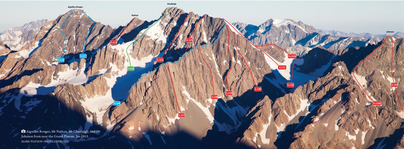
Peaks between Reay Col and Malte Brun Pass above Murchison Glacier, May 2017
Routes
| Reference | Title | Grade | Length | Pro | Quality | Alert | Operations |
|---|---|---|---|---|---|---|---|
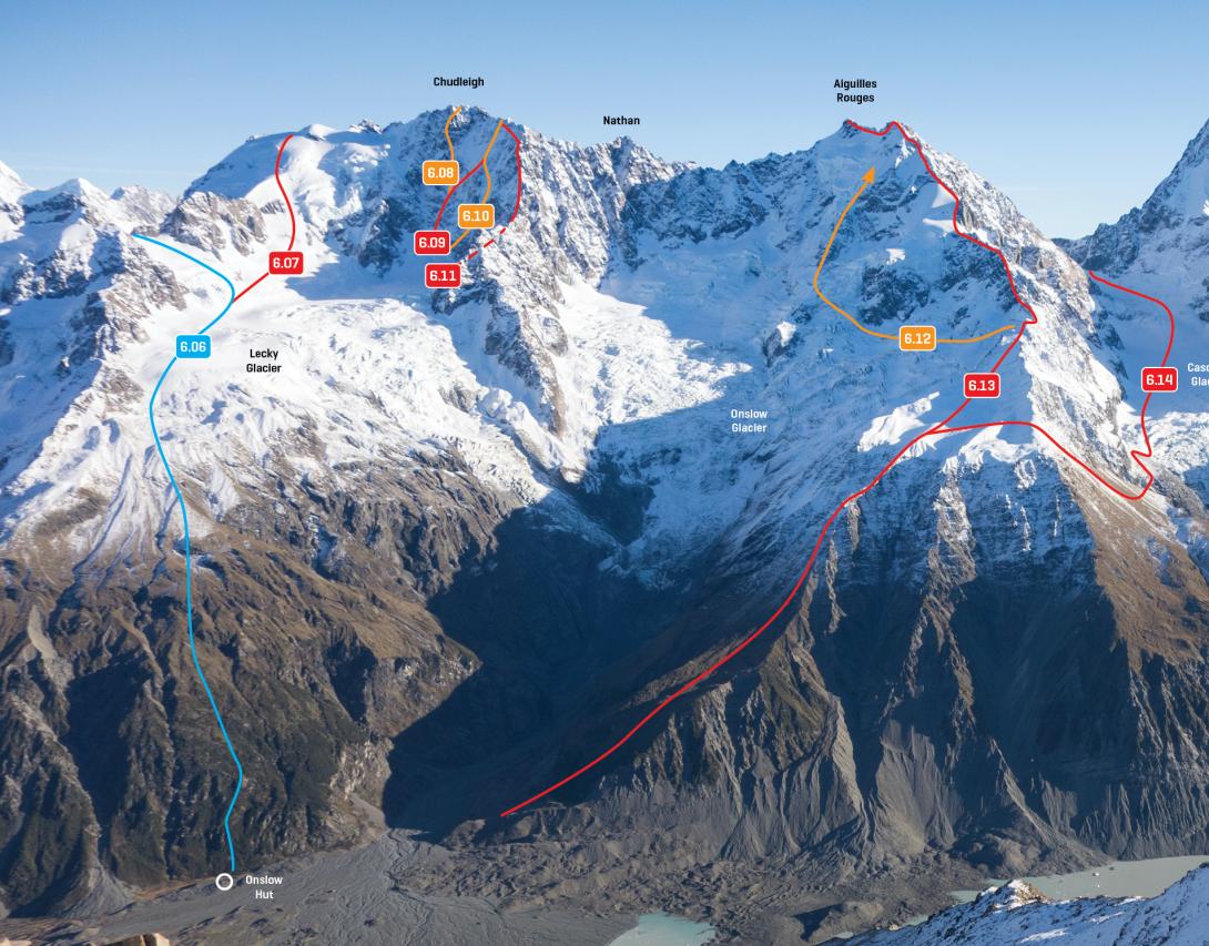
| 6.08 | 6.08South East Face Direct, IV,6,M5 | IV,6,M5 | 0m | ||||
|
Begin in the centre of the face with one pitch of tricky mixed climbing (limited protection), followed by two pitches traversing to the right, and then three pitches straight up. The next two pitches are the crux, and were about M5 with poor protection for the first ascentionists. Three more pitches up 45–50 degree snow leads to the summit ridge. The first ascentionists accessed the face from the Tasman via the Reay Glacier.
|
|||||||
| 6.09 | 6.09Walking the Dog, IV,5 | IV,5 | 0m | ||||
|
This route on the south-esat face may share its start with the Direct. From the Lecky Glacier névé, ascend mixed ground on the left of the face, and then ascend and traverse right to an arête, topped by an exit gully 100m north of the summit.
|
|||||||
| 6.10 | 6.10Spaghetti Route, IV,5 | IV,5 | 0m | ||||
|
From the Lecky névé, ascend steep mixed ground ‘directly under the summit’ to gain a snowfield, then traverse left and up to gain a prominent snow arête (possibly the same arête as Walking the Dog). Finish up gullies to the north of the summit.
|
|||||||
| 6.11 | 6.11East Ridge Variation, IV,4 | IV,4 | 0m | ||||
|
From the true left edge of the Lecky Glacier, climb onto the ridge where it begins the final sweep to the summit. Ascend for 300m, then traverse diagonally left for at least five rope lengths to finish at the same point as the Spaghetti Route.
|
|||||||
| 5.121 | 5.121North East Ridge, III,2+ | III,2+ | 0m | ||||
|
From the Barkley Glacier, ascend a couloir to the low point in the ridge (Barkley Col) then climb the ridge, which is at first pinnacled and then rises steadily. The rock is loose.
|
|||||||
| 5.122 | 5.122North Face, III,3 | III,3 | 0m | ||||
|
From the upper true right branch of the Barkley Glacier, head right up a small ice ramp to gain a large snow/scree shelf low on the main north face. Climb rock to the right of the big gully to join the top of the North West Ridge.
|
|||||||
| 5.123 | 5.123North West Ridge, II,2+ | II,2+ | 0m | ||||
|
Best approached from the Reay valley via the Walpole Glaciers, but can also be reached from the Langdale or Barkley Glaciers. Once on the ridge, ascend a pleasant snow arête that leads high onto the mountain, then climb a short stretch of rotten rock to the summit. A good descent route.
|
|||||||
Images