The Karangarua catchment contains a huge range of alpine, subalpine and forest settings. The Karangarua track provides a fast route to several remote headwaters including the Landsborough, Troyte and Douglas valleys. The western slopes of the Main Divide in the upper Douglas valley form arguably the most majestic setting in the Southern Alps.
Map
Landing sites in the area are at Christmas Flat Hut, Horace Walker Hut, and the Horace Walker névé.
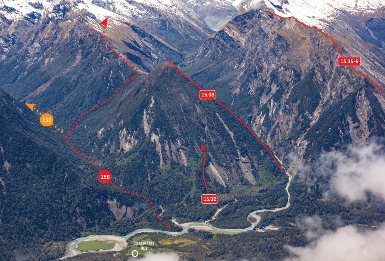
Karangarua River Route
Route 15A, grade I, 1
The route up the Karangarua valley from State Highway 6 to Christmas Flat Hut involves rough going and is often impassable due to heavy rain, but it is generally well marked and allows good access to relatively isolated peaks around the head of the Landsborough. DOC aims to regularly cut and mark this route, and frequently updates the route description (see http://doc.govt.nz).
SH6 to Cassel Flat Hut: 4–5 hrs
Cassel Flat Hut to Lame Duck Hut: 5–7 hrs
Lame Duck Hut to Christmas Flat Hut: 2–3 hrs
Cassel Flat to Horace Walker Hut
Route 15B, grade II, 1+
This is a classic transalpine route that forms part of an excellent loop incorporating Harpers Rock and Christmas Flat.
DOC occasionally maintains the route from Cassel Flat to Horace Walker Hut via Conical Hill Saddle, which is mostly unmarked, difficult, and requires a very high standard of navigational skills. DOC provides a good description of this route, which is regularly updated (see http://doc.govt.nz).
Why is there no route up the Douglas River itself, you may ask? Many have tried to find a way up the lower gorge, but nobody has ever managed it.
Cassel Flat Hat to Conical Hill Saddle: 5 hrs
Conical Hill Saddle to Horace Walker Hut: 6–8 hrs
Upper Regina Creek
Route 15C, grade I, 1
Travel on the upper portion of Regina Creek is reported to be pretty good, and there are apparently a couple of bivvy rocks in the headwaters. A crossing has been made from there to the Horace Walker, and there appears to be reasonable access to Mt Glorious.
Angus Russell, Bernard Teague and Edgar Williams crossed from the head of Regina Creek to the lower Horace Walker in January 1948.
Horace Walker Hut to Harpers Rock
Route 15D, grade II, 1+
The route around the Douglas lake involves some steep, exposed gravel slopes and rock slabs, and should not be attempted during bad weather. From Horace Walker Hut, follow the river upstream to the lake and walk around the true right lakeshore until a bluff blocks progress near the upstream end. Climb up to a gravel and tussock shelf 100m above the lake, traverse east for 200m, then climb another 100m to another sloping gravel shelf. Sidle east for 500m over steep hard gravel and slabs to reach straightforward scree slopes that lead back down to the lower Douglas Glacier. Cross the moraine of the lower glacier (or the alluvial gravel fan between the glacier and the lake), and then climb the moraine wall to Harpers Rock.
The boulders around the stream are generally more stable than the rest of the moraine wall. Harpers Rock Biv is the biggest rock on the edge of the Fitzgerald Flats, not far from the stream.
A party in 1946 observed that the Fitzgerald Glacier had retreated about half a mile since 1935. The Douglas Lake had started to form by then but was easy to bypass on gravel and sand beaches.
Arthur Harper and Ruera Te Naihi explored the Fitzgerald and Douglas Glaciers from Karangarua Saddle in January 1895.
Horace Walker Hut to Wicks Col – Dave’s Route
Route 15E, grade II, 1
This is a satisfyingly sneaky route involving few difficulties (David Eaton, 2005). From the hut:
Travel up the Horace Walker valley to the top of the large flat, then pick a line up the bouldery slopes to the east to reach a prominent shoulder at 1840m (BX15 531 600).
Alternatively, to reach the shoulder more directly from the hut, a tussock spur beginning 500m north of the hut can be used (climbing through BX15 525 590), but care is required to avoid scrub and greasy slabs in the lower 200m. From the 1840m shoulder, ascend on a rising traverse around the northern side of Pt 2192m, climbing towards Pioneer Peak up to 2200m, then sidle to Wicks Col.
Horace Walker Hut to Wicks Col via Wicks Glacier
Route 15F, grade Il, 1+
This has historically been the most commonly used route to the Horace Walker Névé, but shrinking of the Wicks Glacier is making it more difficult around the lower glacier and directly below Wicks Col itself.
The ascent can begin anywhere between the hut and the downstream end of Douglas Lake, but make sure you find a good corridor through the scrub below 1100m.
If the weather is fine, the tussock above the scrub provides a very scenic bivvy spot.
There are bare slabs below the Wicks Glacier in most seasons. These are not steep, but would be unpleasant when wet. A narrow lead of snow right under the bluffs south of Pioneer Peak seems to hold on until at least midsummer, and usually provides the most straightforward access on and off the glacier.
The glacier can be fairly crevassed below about 2000m – some zig-zagging will be required after early summer. The upper glacier provides straightforward travel to Wicks Col. There can be a large bergschrund below the col, in which case a higher col to the east may offer an easier route off the glacier.
Christopher Johnson, Scott Russell and Archie Scott crossed Wicks Col in January 1935, crossing from the Douglas valley to the Copland valley via Blizzard Peak and Welcome Pass (in a blizzard).
Wicks Col to Welcome Pass
Route 15G, grade II, 1+
From Wicks Col, sidle approximately 200m east and then descend on a north-east bearing to the Horace Walker Névé. This route should involve the least-crevassed slopes, but other routes may be preferable depending on the season.
The route between the Horace Walker Névé and the Douglas Névé passes over the 2350m shoulder between Lucy Walker Pass and Pt 2451m. This is technically straightforward, but good navigation skills are essential during poor visibility. Large crevasses are common on the névé. From there to Welcome Pass, travel underfoot is easy, but route finding can be complicated by some humongous slots. Careful with your rope work – avoiding being parallel with the crevasses can be difficult.
See Route 14K for information on the Copland side of Welcome Pass.
Christopher Johnson, Scott Russell, and Archie Scott crossed Welcome Pass in January 1935.
Direct route from Douglas Lake to Douglas névé
Route 15H, grade IV, 2
This novel route is worth a mention for those with little fear. From the true right edge of the Douglas Lake, climb directly up to the true right edge of the Douglas névé (under Blizzard Peak). This involves avalanche-prone, slabby travel beneath huge bluffs. The waterfall at the base of this route is reportedly straightforward to bypass.
Harpers Rock to the Douglas névé
Route 15I, grade III, 2
For access between Harpers Rock and the Southern Douglas Névé (below Brunner Col), use the easy West Ridge of Mt Thomson (route 15.18). Access between the southern Douglas névé and the main Douglas névé is straightforward until massive blocks of winter snowpack slide off into the Douglas valley, exposing smooth rock slabs west of Mts Brunner and Stephen. This usually begins in early summer. The slabs themselves are easy-angled, but transitioning between the pockets of remaining névé and the slabs can be problematic. This is an active, dynamic area – move quickly and be careful!
Harpers Rock to McKerrow Glacier via Douglas Pass
Route 15J, grade I, 1
A cairn at BX15 565 549 marks the base of the route on the north side of the pass. Straightforward tussock slopes on the Douglas side, with a few bluffy sections that are best avoided by sidling on slippery tussock out to the north-west. The Landsborough side consists of slumping gravel terraces.
The pass was reached by Charlie Douglas from the Landsborough in 1889. Tom Fyfe and George Graham crossed the pass in 1893 (from the Mueller Glacier and McKerrow Glacier to the Fitzgerald flats, before returning the same way).
Horace Walker Hut to Christmas Flat Hut via Red Deer Col
Route 15K, grade II, 1
This unmarked crossing involves a bit of scrub bashing but provides the most direct route between Christmas Flat and Horace Walker Huts. It may also provide good access onto the eastern Liberty Range.
- From the true left of the Douglas River on the lower end of the flats beneath The Pommel (BX15 525 573), start climbing up the true right side of the creek which drains a large shelf below Red Deer Col.
Where this stream forks, take the true left fork, and then soon afterwards climb out onto the true left bank, sidle across to the right (west) and angle up onto a spur. This takes you to a tussock bench on the lower part of the large shelf. From here, veer left (south) towards the creek coming out of the bluffs above, at approximately BX15 521 572. Begin up the creek then move right onto a shoulder on the true left. Follow a vague spur straight up to the upper tussock basin, which is sidled on the true left to reach the col. - Alternatively, the col can be accessed from the flats downstream from the Horace Walker confluence, which usually provide a good crossing of the Douglas River at their downstream end. After heading back up the true left bank, enter a gully flowing north-west off the 1000m scrub and tussock knob (beginning at BX15 516 579). Work your way onto the knob, turn right to climb through scrub up the small ridge above and then climb through a short section of bluffs to reach the edge of a tussock face at about 1140m (BX15 517 577). Ascend the slope then angle left below prominent bluffs join the route to the col at about 1450m.
To reach Christmas Flat, descend the gully directly below the col until 1340m, and then sidle right (west) onto the spur between Baking Oven and Driver Creeks. Descend to the scrub line, and then follow the true right branch of Baking Oven Creek (avoiding difficulties by bashing through scrub) all the way down to Christmas Flat.
Lame Duck Flat to Liberty Range
Route 15L, grade I, 2
The Liberty Range is the range extending west-north-west from Mt Howitt, separating the Douglas from the upper Karangarua. Apart from the occasional crossing of Red Deer Col and the odd hunter, this range sees few visits.
It is possible to access the large shelf at 1500m to 1600m on the Karangarua side of the range from Lame Duck Flat. Start up the lower part of Coleridge Creek and take the true right branch three forks in a row. The creek on the map is marked incorrectly. The last fork is at about BX15 473 572, slightly above 900m.
From there, the route is up a scrub and fern gut on the true right. At one point go in through some scrub to avoid a difficult, greasy section. Above 1000m, angle up and right along grass benches to gain the tussock tops above. There may also be other good routes to the tops using slopes in the vicinity of Lily Creek.
Christmas Flat Hut to Landsborough valley via Karangarua Saddle
Route 15M, grade II, 2
There is no marked route upstream of Christmas Flat Hut. To avoid the worst of the scrub, follow the riverbed upstream to a prominent fork at BX15 522 544. There is a brief scrubby section en route on the true right to bypass some large boulders.
From the forks, climb straight up through tussock and light scrub towards Mt Howitt, then at 1300m head right (south-east), and descend about 20m to a level section of the stream draining the south-west slopes of Howitt. Cross the stream and walk up easy slopes to the saddle.
There is an exposed route into the Landsborough from the saddle. It is not technical, but care and a good head for heights are required. Head south-west on the Hooker Range towards Mt Townsend until immediately below the end of a prominent line of bluffs on the Landsborough side of the range (BY15 533 534).
Veer left and descend slowly along the shingle ledge just below this line of bluffs. Steep spurs of snowgrass break the ledge in two locations. Getting around these spurs requires a very good head for heights, but there are faint animal trails providing footholds in the dirt. The ledge leads to the top of a large scree slope below the east face of Townsend, which leads to the Landsborough River.
If the above description sounds intimidating, a more popular and scenic (but much longer) option is to traverse Howitt and the Gladiator to Douglas Pass.
Arthur Harper reached Karangarua Saddle in December 1894. Later, with Ruera Te Naihi, he crossed into the Landsborough valley on a journey from the Karangarua to the Haast River and back in December 1894 and January 1895.
Christmas Flat Hut to Karangarua Saddle: 3–4 hrs
Karangarua Saddle to Landsborough River: 1.5–2 hrs
Karangarua valley to Troyte basin
Route 15N, grade I, 1
A complicated and difficult hunters route through the Troyte River gorge reportedly exists, but the simplest way to enter this remote valley begins from the Karangarua valley track about 200m upstream of the Troyte confluence.
Climb through bush to a shoulder at 880m, and then climb south-east up a flax and scrub face to 1100m. Sidle south, and then take a descending sidle through scrub and bush to gain the down-valley end of a tussock tongue at BY15 492 539.
There are several “trogs” (bivvy rocks) and good campsites in the upper Troyte. A good rock is at BY15 549537, with a few more near the gully leading up to the Hooker Range.
Karangarua valley to Troyte basin: 4 hrs
Troyte basin to Landsborough valley
Route 15O, grade II, 2+
It is possible to cross between the Troyte and the Landsborough over the saddle between Townsend and Fettes.
From the Troyte, the route involves some moderately steep slabs and loose rocky gullies.
To descend into the Landsborough, traverse along the range towards Townsend for a good 200 metres, sidling difficulties on the Troyte side, to approximately BY15 519 519. Below here is a break in the bluffs on the Landsborough side. Descend south to the stream that joins the Landsborough 400m downstream of Fiasco Creek.
Phil Novis, Geoff Spearpoint, February 2007
Troyte basin to Makāwhio valley
Route 15P, grade II, 2+
There are two crossing points on the ridge between the Troyte and Makāwhio valleys. The ridge connecting the two passes is negotiable but involves some exposed rock climbing.
- Highland Pass BY14 478 523 is the southernmost, and is the easiest on the Makāwhio side. When there's plenty of snow still lying in the gullies, it's also the easiest on the Troyte side. To reach the Makāwhio from Highland Pass, drop straight down snow slopes and a rocky gully to avalanche debris at the head of the valley.
- In late summer, a waterfall becomes exposed in the gully on the east side of Highland Pass, making Troyte Col BY14 477 530, the northernmost crossing, more attractive. However, it’s still difficult due to obstacles on both sides.
Shelter
- Cassel Flat Hut: altitude 175m, grid ref: BX14 441 612. A six-bunk hut popular with hunters, and a useful staging post for those entering or exiting the Douglas or Karangarua. The sandflies outside the hut are fierce.
- Lame Duck Hut: altitude 570m, grid ref: BX14 476 559, four bunks.
- Christmas Flat Hut: altitude 755m, grid ref: BX15 510 548, four bunks.
- Horace Walker Hut: altitude 915m, grid ref: BX15 520 581. A remote four-bunk haven that is popular with hunters. Plenty of camping nearby if the hut is occupied.
- Harpers Rock Biv: altitude 1230m, BX15 566 563. This huge rock (sleeps up to ten) has been a base for remote adventures for over a century. The shelter beneath the rock was enlarged, with a rock wall constructed to divide the sleeping areas and reduce drafts, by the Riddiford party in December 1946. Since then the rock has been inundated with large deposits of silt during very large floods and is apparently not as spacious as in the “good old days”. However, it still provides reliable shelter in foul weather, albeit without much headroom.
- Trogs in the Troyte: the Troyte basin is famous for its bivvy rocks, or “trogs” but the exact locations of the good ones are unknown.
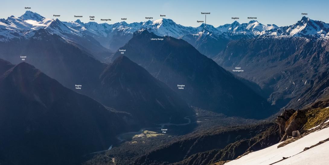
Karangarua catchment from near Mt Ritchie, November 2017
Images