The Copland is a catchment of extremes. One of the most popular tracks in Westland allows fast travel along the full length of the main valley, with huts and hot pools. Elsewhere, be prepared for thick bush, scrub and uncompromising terrain.
The Copland is bounded by the remote Navigator Range to the north, the Main Divide to the east, and the Sierra Range to the south. The slopes of the Navigator Range drain into Architect Creek, the Ruera River and the Strauchon River.
Map
Aircraft access is not permitted. The nearest landing site is the Horace Walker névé, 1–2 hours from Welcome Pass.
For up-to-date information on the Copland Track and huts, check with the Department of Conservation visitor centre in Franz Josef, or www.doc.govt.nz.
DOC aims to maintain the Copland route as far as the base of the zig-zags near the head of the valley. The track often suffers from avalanche damage above Douglas Rock Hut, so in early summer (before track cutting) it may be difficult to follow in places.
Harry Cuttance and Charlie Douglas reached the upper Copland valley in 1892. Dick Fiddian and Arthur Harper reached the Copland Glacier in March 1895.
Access from Copland track to head of Architect Creek
Route 14A, grade II, 1
From the west end of the Architect Creek bridge, follow the edge of the bush terrace on the true right of Architect Creek until the first creek shown on the topomap. Climb the spur on the north side of this creek to about 700m, then sidle to the north, slowly descending, to meet Architect Creek just downstream of Chlorite Creek.
From here, travel is straightforward in the creek bed and on river flats (good camping) until just before Vickers Creek. From the top of the flats in low flow it is possible to stay in the bouldery creek bed, but moderate to high flows require much slower travel in scrub on either bank.
Leave Architect Creek at 860m and climb up a dry watercourse on the true right to 1020m, and then traverse above the scrub to the head of valley. Close to Architect Creek at 1040m (below the route to Whales Saddle) there are good campsites.
From Copland track to Chlorite Creek: 3–4 hrs
From Chlorite Creek to upper Architect Creek basin: 5–7 hrs
Upper Architect Creek to Cook River via Whales Saddle: 6–7 hrs
Access from Copland track to Ruera valley
Route 14B, grade II, 1
Crossing the Copland River is usually okay at Welcome Flat during low flows. The alternative is to do a slow bush bash up the true right from Welcome Flat Hut.
Access up the Ruera is best up the true left (east) bank. Travel is slow, through dense scrubby bush, but the bouldery riverbed itself is even worse, so stay well above the river. At least one party has used an open creek bed about halfway up the valley to gain most of their height.
Charlie Douglas travelled up the Ruera in 1892.
Copland valley to Strauchon Glacier via Jungle Creek
Route 14C, grade II, 1
A good route if river levels are low. Crossing the bouldery Copland River should not be taken lightly, but during low flows is possible with care. There appears to be an okay crossing at about BX15 592 631.
Alternatively, you can do a hideous bush-bash from Welcome Flats Hut up the true right of the Copland River (6 hrs to Jungle Creek).
From the Jungle Creek confluence, bash up through bush on the true left of Jungle Creek, then follow the creek bed after the gradient eases, all the way to the tussock terraces.
The descent of the 250m high moraine wall to reach the glacier lake is best directly beneath Darkwater Saddle.
Dick Fiddian and Arthur Harper got to below Darkwater Saddle via Jungle Creek in April 1895.
Copland River (after crossing) to Strauchon Lake via Jungle Creek: 3–5 hrs
Copland valley to Strauchon Glacier via Strauchon River
Route 14D, grade II, 1
The bush on the true left of the Strauchon River has been used by several parties, but is slow going and only recommended for parties exiting the valley. The Copland and Strauchon Rivers are steep and bouldery near their confluence – crossing either is a serious proposition. A large vegetated rock island near the junction with Tekano Creek has a steep 5–10m step on each side. The legend of a cable across the Copland just above the Strauchon confluence has not been verified.
Charlie Douglas reached the lower Strauchon Glacier via the Strauchon River in 1892.
Copland River (after crossing) to Strauchon Lake via Strauchon gorge: 6–8 hrs
Copland valley to Strauchon Glacier via lower Banks Range
Route 14E, grade II, 2
In fine weather, this transalpine route is a scenic option for entering the Strauchon and involves practically no scrub or bush.
Cross the Copland 1.5–2 km above Douglas Rock Hut. Ascend 200m up the wide, steep stream bed beginning at BX15 609 620, and traverse west through boulders and tussock above the thick scrub to reach the ridge separating the Strauchon and Copland valleys at 1240m.
Climb up the ridge to about 1760m, and then traverse northwards on rocky terrain, slowly losing height, to reach the top of a steep gravel gully at about BX15 612 636. Descend this to reach a bouldery stream bed, and traverse at 1200–1300m to reach the next stream to the north.
Descend this to the Strauchon lake outlet, and follow the base of the true left moraine wall along the lake edge (good travel in 2015) to the gravel flats at the head of the lake. Crossing the river is usually easy here.
Rob Frost, Geoff Spearpoint, January 2015
Douglas Rock Hut to Strauchon Lake via lower Banks Range: 6–8 hrs
Copland valley to Strauchon Glacier via upper Banks Range
Route 14F, grade lI, 2+
There is a steeper route over the Banks Range closer to Sibyl Peak, which is more direct for parties accessing the upper Copland via FitzGerald Pass rather than the lower Copland. From the base of the zigzags on the Copland Track route, cross the river below the lake and then climb onto the moraine wall on the true right. Grunt up steep scree and/or snow and some quite pleasant rock, gradually curving toward the saddle northeast of Pt 1970m. A short slabby section on the Strauchon side leads to a descent on snow and scree. Traverse over the spur to the north to reach the stream draining the Banks Glacier, and then either continue north on the moraine terrace or drop down to the lakeshore.
Aat Vervoorn, 1986
Copland track zig-zags to Strauchon Lake: 6–8 hrs
Hooker Glacier to the Strauchon Glacier
Route 14G, grade II, 3
The quickest route into the Strauchon is from the Hooker valley via Baker Saddle. Both sides of the saddle can be badly crevassed in late summer, and there is significant icefall risk from La Perouse. The condition of the Hooker icefall to Pudding Rock usually determes the viability of this approach.
If the Hooker icefall or eastern slopes of Baker Saddle are cut off, a scenic approach would be to traverse the Main Divide from FitzGerald Pass to Baker Saddle. The steep section on the south ridge of Raureka would be the main obstacle on this route.
Strauchon Glacier to Strauchon Face of Dilemma (direct]
Route 14H, grade II, 4+, 16
From the Strauchon Glacier, start at the top of the centre-left snow cone, near the cascade draining from the hanging glacier. Occasional bolts were placed in 1991 but these are difficult to find and not necessary. Climb up the corner of a left-leading slab (crux) for two pitches, then turn right and follow up broken ground, next to the cascade, to a steep wall. Traverse right on a big ledge and up left on another slab to a rib below the hanging glacier. This is a good bivvy spot (five pitches up).
Strauchon Glacier to Strauchon Faces of Dilemma and Unicorn
Route 14I, grade II, 4
This is the original access route to the faces, and is probably slightly less technical than Route 14H, but may still be a little dodgy following the huge 2013 rockfall from Unicorn.
Start from the large snow cone directly beneath the Dilemma-Unicorn corner. Ascend a narrow gully and a left-leaning slab to reach a shingle rib to the right of the hanging glacier.
If heading for Dilemma, move left from the shingle rib to the hanging glacier.
If heading for Unicorn, move right from the shingle rib into a major couloir, which eventually leads all the way up to a point about 200m below the crest of the Banks Range, west of Unicorn. About 200m up the couloir, the left-hand side of the face will be above you on the left.
Shelter
- Architect Creek Hut: altitude 110m, grid ref: BX15 487 666. A dark little building with two bunks – only use it if you have to or really don’t like the crowds at Welcome Flat. This hut may be removed – check with DOC.
- Welcome Flat Hut: altitude 430m, grid ref: BX15 536 647. A two-storey, 31-bunk hut a minute from Welcome Flat hot springs. In summer, the hut has gas stoves and a resident warden. Bookings are required via www.doc.govt.nz. A good bivvy rock nearby gets crowded with people and sandflies during summer.
- Douglas Rock Hut: altitude 750m, grid ref: BX15 596 623. A charming 8-bunk hut built in 1930 and still well maintained.
- Bannister Rock in the Ruera valley is located on the true left of Darkwater Stream, about 100m upstream of the confluence with Lyttle Stream.
- In the Strauchon valley, moraine terraces below Darkwater Saddle provide excellent camping, and there are a couple of nice grassy deltas on the true left shoreline of the glacier lake. A small (1–2 person) bivvy rock sits on the moraine terrace above Jungle Creek at about BX15 598 654. A bit of searching among the hundreds of other boulders on the terraces is likely to find more good bivvies. Bivvying on the Strauchon Glacier is not recommended due to rockfall and avalanches.
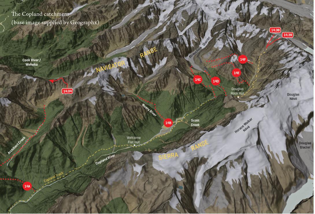
The Copland catchment and key access routes