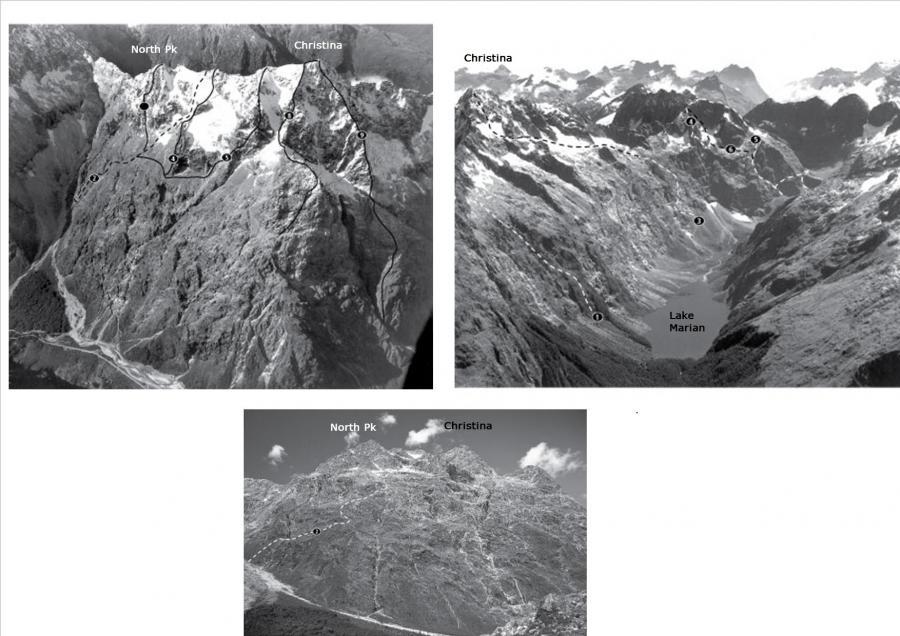
Routes
| Reference | Title | Grade | Length | Pro | Quality | Alert | Operations |
|---|---|---|---|---|---|---|---|
| 2 | 2Original Route | 0m | |||||
Start up Cirque Creek, ascending a steep tussock and scrub fan to below a large vertical bluff. Trend right on a long traverse crossing two sculptured watercourses. From here it gets a little tricky; ascend steep tussock directly up until a small terrace leads right to a large snow basin (avoid the temptation to head directly up as the terrain steepens dramatically) then continue traversing right into the centre of the face. Follow easy slopes to the ridge north of the summit. |
|||||||
| 4 | 4Skyline Buttress | 0m | |||||
The buttress is approached by sidling down from high on the Original Route. |
|||||||
| 5 | 5The European Connection, 20 | 20 | 0m | ||||
|
Seven pitches. A ridge and face route on the skyline as seen from Homer Hut,
|
|||||||
| South West Face | 0m | ||||||
Climb the south side of a prominent gut above Lyttle's Flat and continue up scree and snow slopes to the col just north of the summit. |
|||||||
| 8 | 8South West Ridge | ||||||
|
From the col northeast of the South Pk, climb a snow gully to join the South |
|||||||
| 9 | 9South Ridge | 0m | |||||
Climb up the shingle to a waterfall which drops out of a prominent west-facing gut, easily climbed on the north side. Early season avalanche danger from the hanging glacier can be avoided by crossing to slabs on the true right. A steep band is crossed in the central section and the rock deteriorates towards the summit. |
|||||||
| East Ridge, III | III | 0m | |||||
|
Cross the Hollyford River and (as for the Christina East Peak route) climb the large scree fan, going round to the right and up a gully, then across a small spur. Descend to a second gully, moving diagonally right into the big gully which is followed to snowfields and the East Ridge. Drop onto the Marian side of the ridge below Pt 1983 and back to the ridge beyond.
|
|||||||
| 1 | 1McLeod Route | ||||||
|
On first reaching Lake Marian head up directly to the Marian Bluffs. Climb a |
|||||||
| Brookes Simpson | |||||||
|
Up the bluffs and snow directly above Lake Marian to the upper Marian Ridge. |
|||||||
| 3 | 3Gordon Hall-Jones Miller | ||||||
|
From the top of the highest snowgrass slope beyond the lake, climb up and |
|||||||
| Complete East Ridge, IV,3 | IV,3 | 0m | |||||
|
Cross the Lake Marian Track Bridge off the Hollyford Road and go directly through the forest to the base of the ridge. The initial ridge was climbed to above the bluffs by Milton Bardsley and Ian Cameron in January 1964.
|
|||||||
