Routes
| Reference | Title | Grade | Length | Pro | Quality | Alert | Operations |
|---|---|---|---|---|---|---|---|
| Low Thumb, North Buttress, 1 | 1 | 0m | |||||
From head basin of Black Birch Creek climb a series of bluffs to gain the summit ridge about |
|||||||
| Low Thumb, East Ridge, 2- | 2- | 0m | |||||
This is best approached from the north branch of Black Birch Creek but can also be reached via |
|||||||
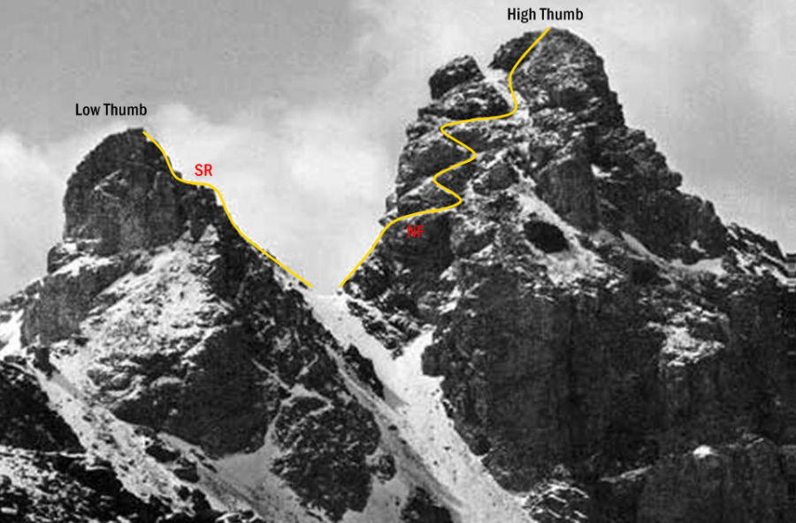
| SR | SRLow Thumb, South Ridge, 2- | 2- | 0m | ||||
The col between the high and low Thumbs is readily accessed from the west. From the col pick a route through steep, loose argillite to the summit, climbing a narrow, left-facing corner if conditions dictate. |
|||||||
| NF | NFHigh Thumb, North Face, 2 | 2 | 0m | ||||
The col between the high and low Thumbs is readily reached from the west. From the col, cross a band of argillite then zigzag along ascending ledges. Finish by climbing either blocky rock or a scree gully on the right to the broad summit. The rock is reasonably firm. |
|||||||
| High Thumb, South Ridge, 2 | 2 | 0m | |||||
Climb a narrow couloir north of Tom Thumb Col. The couloir merges with steep, loose rock and narrow gullies but joins the South Ridge near the summit, avoiding deep chasms and steep walls at the south end of the ridge. Climb the steepening ridge, taking occasional detours to the west side of the arête and negotiating a short step just before the summit. Alternatively, the South Ridge is readily reached via scree from the western side of the col north of Pt 2315 metres. |
|||||||
| Low Thumb, West Face | |||||||
|
A short climb through steep, loose, and exposed rock. Ascend scree from the col to the north-west of the Low Thumb before climbing up the corner of the main face. Trend slightly left then up, testing the rock before committing. When the ridge is gained, cross the top of a gully to join the east and south routes immediately before the summit. A straightforward descent through loose rock awaits on the east side, to regain the north-west col if desired. The grading of this route is intended to be in keeping with other routes in the immediate vicinity. |
|||||||
in association with the Canterbury Mountaineering Club