Split Peaks are two prominent peaks of approximately equal height forming a heart-shaped outline when seen from Two Thumb Stream. They form blocky buttresses and prominent ribs of variable to good rock, potentially producing routes up to 150 metres long. The easiest access is from adjacent cols,
which lead to short scrambles of a few tens of metres of height gain. A traverse of the entire ridge from Tom Thumb Col to the col north of Mt Caton is yet to be completed and would involve negotiating a steep gendarme at the northern end and some short, steep faces. Split Peaks were first climbed by Bill Cullens, Stan Forbes and Frank Gillett in December 1934. The party had set out to climb The Thumbs but in the absence of any good maps or route descriptions they set off in error up Split Peaks. A view from high on the route revealed their mistake.
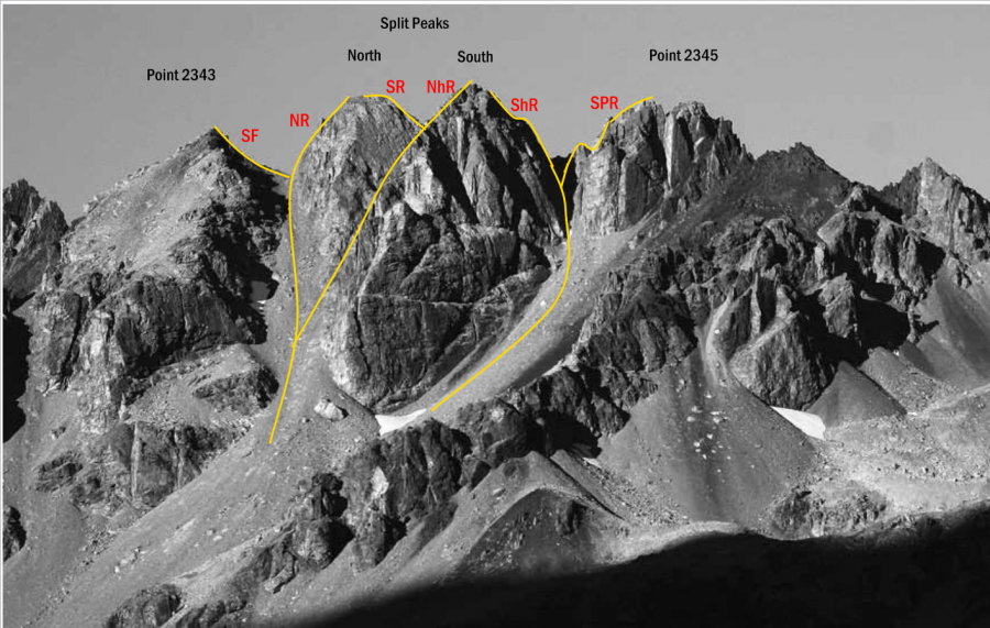
The cols north, south and between north and south Spilt Peaks can be reached via steep scree or snow from Black Birch Creek.
Places
| Type | Name | Alert |
|---|---|---|
| Mountain | Pt 2343 |
Routes
| Reference | Title | Grade | Length | Pro | Quality | Alert | Operations |
|---|---|---|---|---|---|---|---|
| NR | NRNorth Split Peak, North Ridge, 2- | 2- | 0m | ||||
From the broad, prominent scree slope that leads to the col on the northern side of the Split |
|||||||
| SR | SRNorth Split Peak, South Ridge, 2- | 2- | 0m | ||||
Start by climbing the broad, prominent scree slope, aiming towards the col on the northern |
|||||||
| NhR | NhRSouth Split Peak, North Ridge, 2 | 2 | 0m | ||||
Gain the narrow col between the two Split Peaks (see South Ridge of North Pk, route above). Climb a short slab and |
|||||||
| ShR | ShRSouth Split Peak, South Ridge, 2- | 2- | 0m | ||||
Climb a steepening gully immediately south of the peak, to a small col. Negotiate a short step |
|||||||
in association with the Canterbury Mountaineering Club