Evans River and glacier
From Smyth Hut, a roughly marked track leads up the true left of the Wanganui to the Evans–Vane junction, sometimes on the riverbed, sometimes in scrubby forest nearby. Vane has a dodgy crossing between big boulders a short way up from the river, and a safer crossing about 20mins further up on a gravel bottom. To continue up the Evans, follow the true left, sidling in open scrub along the banks as necessary. Travel is generally straightforward, leading to extensive gravel flats and campsites in the upper valley. Moraine boulders lead more steeply up the Evans Glacier.
Vane Stream
In low flow Vane Stream can be crossed fairly easily near the junction with the Evans River, but there is a safer crossing with a gravel bottom between boulders, about 30mins upstream. Travel is reasonably okay on the true left of the Evans River, with little scrub-bashing.
Bracken Snowfield
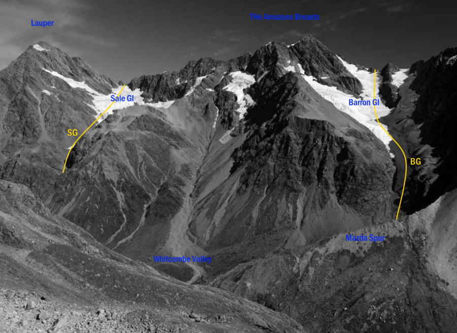
The Bracken offers good glacier travel from the Ramsay Glacier to Full Moon Saddle and, in spring and summer, good access down to the Evans and Wanganui Rivers. Alternative routes on and off the snowfield include the Katzenbach Ridge, giving access to McKenzie Col, Seddon Stream and the Waitaha; and the Barron Glacier and nearby Sale Glacier leading towards Whitcombe Pass.
Katzenbach Ridge has been used since the 1930s to access the upper Wilkinson River from the Bracken
Snowfield. Sidle onto the northern flank of the ridge from the edge of the Bracken, passing through a
bluffline at the 2020 metre contour and continue across to the snowfield north of Pt 2068 metres. This
is the easiest route. Alternatively, on a calm day the rotten rock and gravel of the upper Katzenbach
Ridge itself can be followed, before dropping 20 metres off it to the north down steep gravel onto
easier travel. The ridge crest further towards Pt 2068 metres becomes gnarly and impractical.
Both routes then converge to descend scree and snowfield, curving down to the right over a rib to
the major gravel gully that drains from Pt 1853 metres. Travel in the lower part of this has deteriorated with erosion, but routes can be found down to the lake edge. Watch for rock fall. The lake can be sidled
at water level on both sides, but the true right is less subject to falling debris. On the true right, cross
the outlet then the low open ground west of Agfa Knob to Seddon Creek. The rock shelters marked
here (Bevernage Biv) are hardly worth the effort unless it’s raining and your tent leaks. They are small
and a scrub bash to get to. Seddon Creek leads to the Waitaha.
It’s worth noting that traversing the Wilkinson River down to the Whitcombe is difficult, slow
and not a good route. If used, stay on the true left. River boulders are huge and travel arduous, and an
alternative is to sidle back in the bush on deer trails, which are numerous, particularly around Walcott
Creek. At the 800-metre contour in Walcott Creek there is a very good bivvy under a huge rock.
Continue along the true left of the Whitcombe, with a couple of scrubby sidles, to the Wilkinson
Hut and bridge.
Used as access to the Bracken Snowfield from Whitcombe Pass. Despite glacial recession this route
remains direct and efficient, but it follows a steep and narrow glacier and parties should be prepared
for crevasses. In a lean snow year or from about February, schrunds may make the route impractical.
David Barron, Chief Surveyor of Westland, advocated for a stockroad over Whitcombe Pass in
1895. The col at the head of the Barron Glacier has been referred to as Kitchinghams Col.
The Sale Glacier is used similarly for access to the upper Ramsay Glacier and Erewhon Col, and is
probably more reliable and easier than the Barron. Don’t be tempted to sidle up onto the moraine wall
from Lauper Stream or Whitcombe Pass as eroding gravels cut access into the valley. Follow up the
stream and then moraine onto the white ice. Higher, at an ice bulge, the best route is usually on the
true right, then easy snow leads to Pt 2051 metres and the upper Ramsay Glacier. Some prefer the Sale
or Barron routes to sidling steep collapsing moraine along the fringes of Ramsay Lake.
George Sale was appointed commissioner of the West Canterbury Goldfields in 1865.
Comments
Attribution
Yvonne Cook and Geoff Spearpoint,
in association with the Canterbury Mountaineering Club