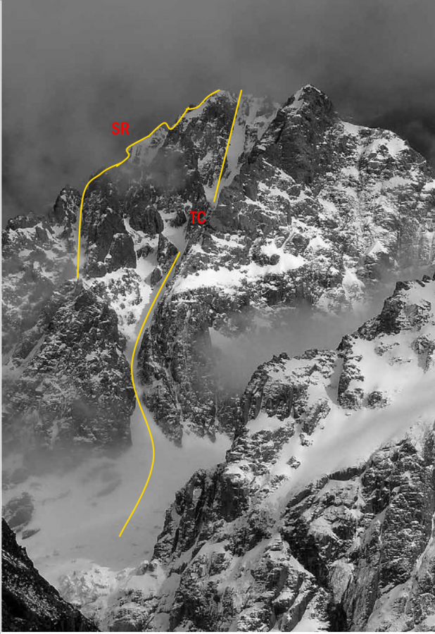
After Hugh Wright and Jim Murphy abandoned their attempt in 1912, to make the first ascent of Mt Arrowsmith, Couloir wasn’t climbed until 1934. There are several options from Lawrence River. The Couloir is the classic route to the summit of Couloir Peak, pioneered by the redoubtable Stan Conway and Tom Newth and the scene of their legendary 2500-foot fall during a storm on the descent. After their successful climb, an avalanche knocked Tom off his feet, he collided with Stan and they tumbled down the couloir in a long series of arcs, alternately airborne, then pounding into the ice as the rope between them became taught and reined in their flight. Eventually the rope coiled around Tom and the arcing stopped. One last flight saw them clear rocks at the bottom of the couloir before hitting the névé and rolling to a stop millimetres from the edge of a crevasse. Both were injured, with Stan having to be evacuated by horse. Despite this, Tom was able to show up for work the next day and the incident was glossed over – although it was more than 20 years before the route was repeated.
Routes
| Reference | Title | Grade | Length | Pro | Quality | Alert | Operations |
|---|---|---|---|---|---|---|---|
| From Lawrence Valley, 2 | 2 | 0m | |||||
Follow the top of the moraine wall above the Lawrence Glacier and from here climb a solid rock ridge to the crest. Traverse south, climbing into a gap with a steep bluff on the north side, then continue to the summit
From a shingle slope, follow the creek draining the north side of Mt Arrowsmith and climb to the upper basin. From here traverse Pt 2474 metres and reach the crest of the range slightly north of Cameron Col.
Start up the glacier where the moraine wall has been breached, then follow scree and snow to the high Twins–Couloir basin. Climb a steep wall of rock to reach the final ridge and summit. |
|||||||
| South Gullies, 2+ | 2+ | 0m | |||||
Take one of the two prominent gullies left of the main couloir which lead to a small plateau on the Lawrence divide. From here, follow reasonably angled rock for the last 200 metres to the summit, or follow a snow-filled gully left of the rock. |
|||||||
| SR | SRSouth Ridge | 0m | |||||
Climb the ridge south of the peak, which leads directly to the summit, starting either on rock or up an ice gully. |
|||||||
| TG | TGThe Couloir, 3 | 3 | 0m | ||||
Follow the Cameron Glacier to the base of the prominent snow couloir cutting the south-east face of the peak. The lower section contains the crux, a steep, two-metre ice wall, after which the route lays back to about 45 degrees and ends about 30 metres from the summit ridge. From here, cross left under the buttress into a short, steep, icy gully then follow good ice for the last 10 metres to the summit ridge. |
|||||||
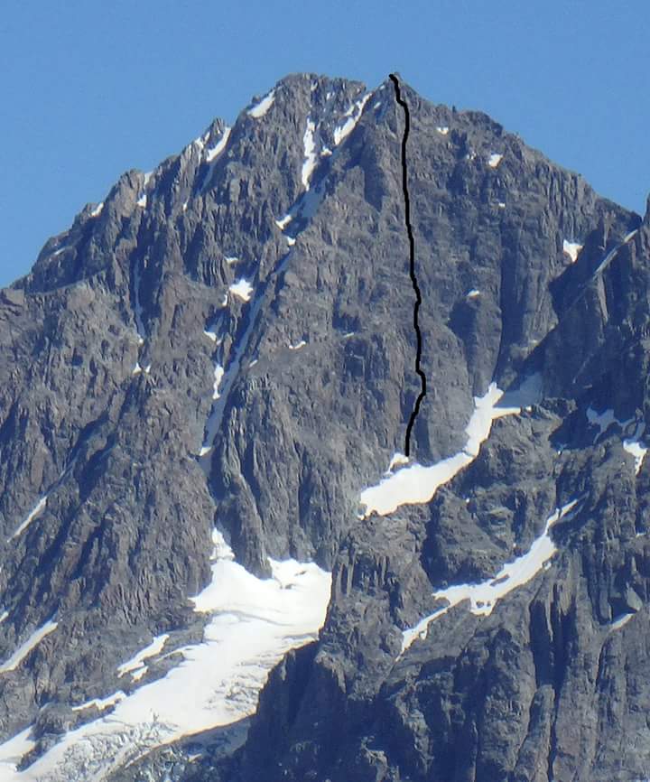
| The Big D, 16 | 16 | 0m | |||||
|
Direct route on East Face of Couloir Peak (2642m). From Cameron Hut, allow 5h for the approach, 7h for the climb, and 7h for the Pitch 1 (40m, 16) – up crack until under roof (20m). Turn the roof by Descent – continue traversing 100m along summit ridge to the SW until at
|
|||||||
Images
in association with the Canterbury Mountaineering Club


The Big D (10p, 16), first ascent Don French and Kevin Patterson, Feb 2014