Mt Murchison was first climbed by Charles Ward and Arthur Talbot in 1913 from the Waimakariri
River, via the White Glacier and North Ridge.
Routes
| Reference | Title | Grade | Length | Pro | Quality | Alert | Operations |
|---|---|---|---|---|---|---|---|
| 1 | 1White Glacier Route, 1 | 1 | 0m | ||||
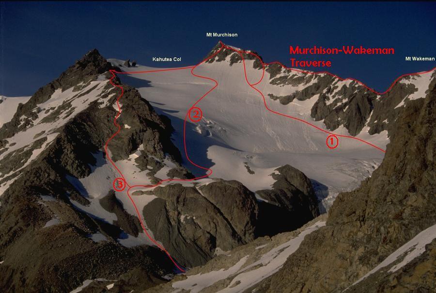
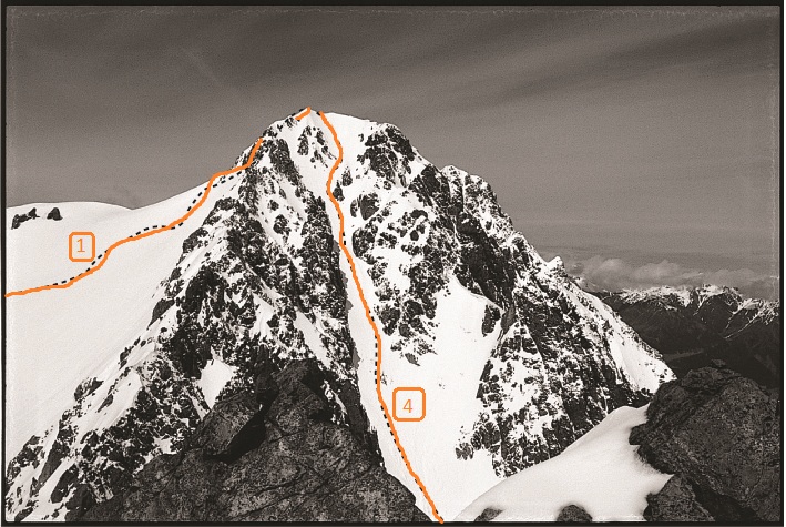
The usual route follows the glacier (up the true left of the icefall on an ice ramp) almost to Kahutea Col. Stay close beneath the North Ridge, to avoid the crevasse areas and then ascend the last couloir which joins the ridge near the summit. (Note : Wet snow avalanches or stone-fall are not uncommon in this short 60m couloir!). |
|||||||
| E1467558 N5237364 | E1467558 N5237364Denas Face, via SW Ridge, IV,3,14,2+ | IV,3,14,2+ | 65m | ||||
|
“Denas the Menace” From Kahutea Col sidle the ice slopes of the Kahutea Glacier névé under Mt Murchison southwest for about 350m. This enters into a large bay of steep ice between rocky spurs. Ascend 60m to the top left-hand corner to gain the southwest ridge of Mt Murchison via a short, loose rock step. This route would likely be cut-off by bergschrunds in late summer. The ridge has extensive rotten rock and numerous crumbling gendarmes that need to be avoided by descending north onto the very exposed and steep ‘Denas Face’. The initial foray onto to the face happens in the first 30m of ridge travel descending a steep gully of vertical bedded rock for about (20m), before sidling out on series of exposed narrow ledges to the nose of a steep rock spur, then reascending towards the ridge. Most travel takes place on the face (well below the crest of the SW ridge). The crux is met about 300m before the summit, and takes place on reliable, firm orange rock (solo-able, Ewbank grade 11 - 14 for 30-40m laterally across the face, and 25m vertical, following cracks and ledges, with a couple of zigzags at the end to regain the SW ridge), and is the only decent patch of rock on the route. Finally scramble to the summit rocks of Murchison.
The crux is met about 300m before the summit, and takes place on reliable, firm orange rock (solo-able, Ewbank grade 11 - 14 for 30-40m laterally across the face, and 25m vertical, following cracks and ledges, with a couple of zigzags at the end to regain the SW ridge), and is the only solid patch of rock on the route. |
|||||||
| 2 | 2White Glacer Variation, 1 | 1 | 0m | ||||
By late summer the above route may be cut by an icecliff for the width of the White Glacier. In this case a good route follows a scree/snow slope adjacent the ridge linking White Col and Kahutea Col. A cross over point onto the White Glacier neve is generally found about 200m up the ridge. In recent years (February) the White Glacier has been cut by a huge bergschrund for its entire width some 150m below Kahutea Col; rock bypasses are very risky to say the least. |
|||||||
| 3 | 3Kahutea Ridge, 2 | 2 | 0m | ||||
The Kahutea ridge can be followed from White Col however be prepared for some very loose, exposed climbs, especially on the final two buttresses. |
|||||||
| 4 | 4From Upper Wlberforce River, 3 | 3 | 0m | ||||
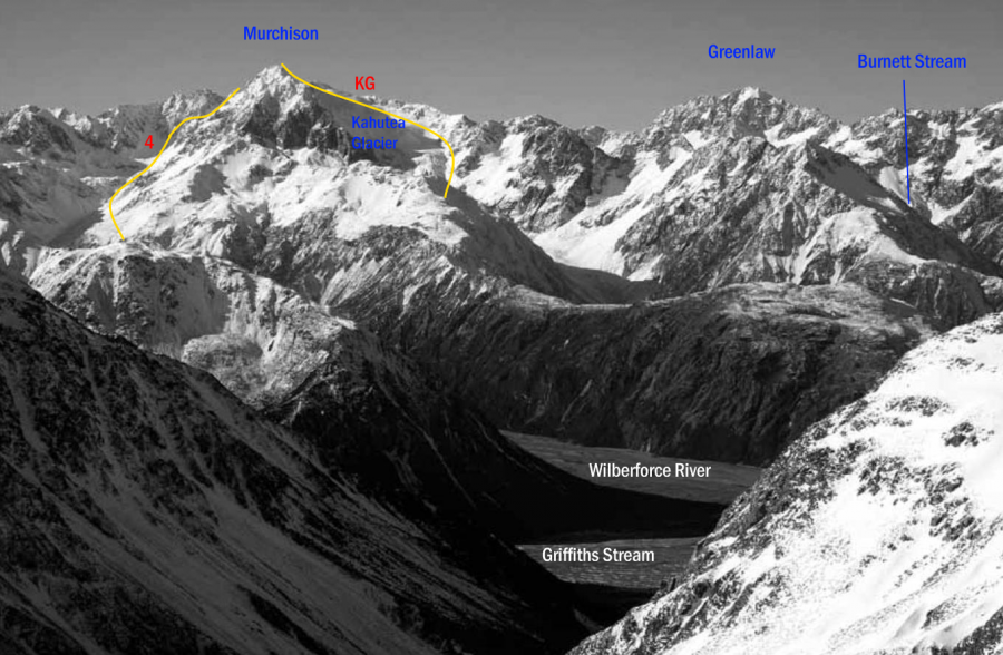
From the upper Wilberforce River via Denas Creek, by traversing upstream to a point directly below the summit rocks. A large scree leads up to a long steep couloir which meets the North Ridge not far from the summit. This route is fraught with dangers, avalanche, rock fall, and really rotten rock to name but a few. It is a seasonal route with a very narrow window of safe conditions (typically August to December, daily conditional). Descent is generally made over Kahutea Col, down the Kahutea Glacier (sticking true left), then sidling left diagonally down to gain the slabs and grassed slopes into Weka Stream. |
|||||||
| KG | KGFrom Kahutea Glacier, 2 | 2 | 0m | ||||
|
Follow the bouldery Weka Stream, to a basin at its head with bluffs on the eastern side. From here continue north along the base of bluffs, beyond the two side creeks draining the foot of the Kahutea Glacier, to a narrow scree slope hidden in the bluffs that trends up and right. Climb the scree and continue traversing up and right, crossing a rock rib above the northern-most of the two creeks that drain the Kahutea Glacier, and make a short descent into this creek down a slab with small ledges. This creek channels serac-fall debris from the snout of the glacier above and should be crossed quickly. Continue climbing up and right, and cross the top of the next side creek draining the glacier ; from here the glacier itself is a short climb. The true left of the glacier generally provides good travel to Kahutea Col ; from here traverse to the North Ridge and scramble up snow and loose rock on the north and east aspects to the summit.
|
|||||||
Images
Yvonne Cook and Geoff Spearpoint,
in association with the Canterbury Mountaineering Club


