Map
Routes
| Reference | Title | Grade | Length | Pro | Quality | Alert | Operations |
|---|---|---|---|---|---|---|---|
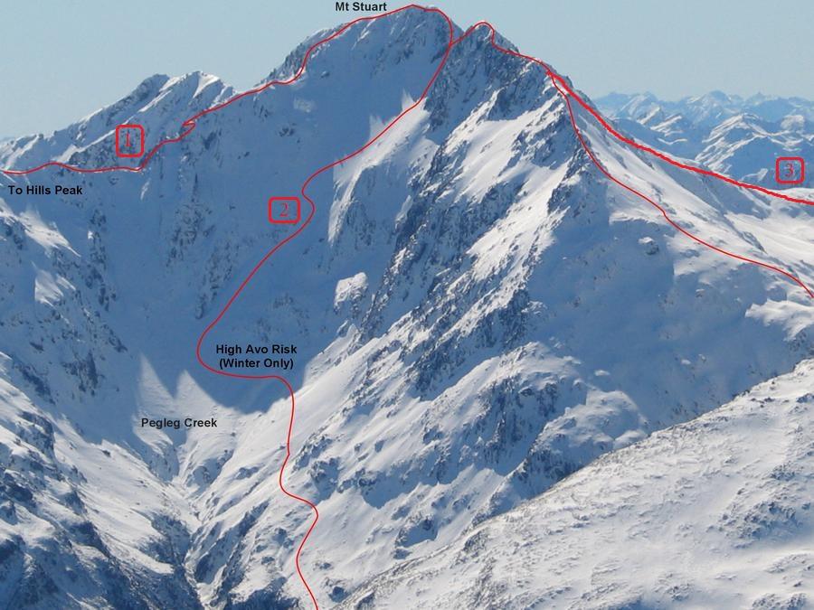
| 1 | 1Via Hills Peak, 1 | 1 | 0m | ||||
Follow the joining ridge with Hills Peak (1640m) |
|||||||
| 2 | 2Pegleg Creek Route, 2 | 2 | 0m | ||||
Commence ascent of West Ridge of Phipps Pk, from Temple Basin goods lift shed (highway 73). Once on the tussock covered slopes begin sidling the contour towards the Pegleg Ck catchment, rising where necessary to avoid multiple gullies. Descend the spur below the 1728 point, crossing Pegleg Ck’s Sth branch, and then continue sidling under the Sth Ridge of Mt Stuart to the basins directly below the summit. From here a series of steep snow/ scree covered slopes lead to the col south of the summit. |
|||||||
| 3 | 3From Deception River, 1 | 1 | 0m | ||||
Ascend the ridge opposite Goodluck Creek, reaching the knoll north of Phipps Pk (This is a bit of a bash!). Traverse through the saddle and ridge to Mt Stuart. |
|||||||
| 4 | 4South Ridge, II,3,2 | II,3,2 | 0m | ||||
|
Commence ascending the west ridge of Phipps Peak from the Temple Basin goods lift, sidling around on the 1500m contour (using prominent fault scarps) onto the escarpment above the south branch of Pegleg Creek. A wide scree gut is met below the 1728m point and descended. Cross Pegleg Creek and ascend slopes towards the prominent rocky bluffs at the foot of the southern ridge. Make your way up through the rocky bluffs to gain the ridge. Follow the ridge to the summit. The majority of the ridge consists of nice grippy orange rock which is enjoyable to climb but as you get closer to the summit the rock becomes very rotten in true Arthur's Pass tradition.
|
|||||||
| 5 | 5Southeast Face, II,3,2 | II,3,2 | 190m | ||||
|
The southeast face is reached by traversing over Phipps Peak, and the 1820m point, or by sidling into the col between Mt Stuart and the 1820m point from Pegleg Creek. Ascend the scree slope from the col towards a left-trending ramp of rock and scree at the bottom of the rock face. Ascend this ramp upwards then traverse off right to join the hanging scree slope. Climb to the head of the scree under a vertical gully. Ascend the obvious, diagonal, left-trending ramp until you reach a rock ledge. From here there are multiple routes up to the South Ridge of Mt Stuart that involve climbing straight up steep, but solid rock, or working your way up through various ledges and chimneys, skirting around patches of scree and/or rotten rock as you go. Once the ridge is gained continue on to the summit.
|
|||||||
Images

