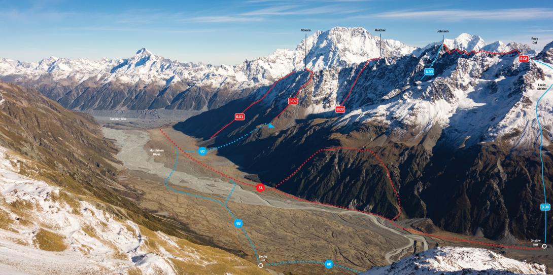
The rock notch of Reay Col is the low point in the ridge between the Reay and Lecky Glaciers, and provides a scenic transalpine trip.
The first crossing was by Arthur Harper and Percy Johnson in 1891.
Map
From Tasman valley: Route 5.132 on topo, grade II, 2. Access to the Reay valley is constantly changing in spring storm cycles. From the Tasman Glacier negotiate eroding moraine walls to enter the Reay valley on the true left. Once through the moraine and onto bedrock, look for a way across the Reay Stream (dangerous in high flow) to access the true right of the valley entrance once the terrain looks navigable on that side. ( The former access via a prominent, rightwards-leaning moraine ledge on the true right has now washed out). Once in the valley, sidle upwards on the true right to the confluence of the Reay and Walpole Streams where small campsites among snowgrass can be found.
Continue sidling on scree on the north side of the valley, then climb up the Reay Glacier. The final slope to the col may consist of steep loose scree in late summer.
To reach Beetham Hut, once into the Reay valley and above the moraine, head north with easy travel on grassy terraces, maintaining roughly the same altitude until reaching the hut.
To descend to the Murchison, drop north-eastwards down the Lecky Glacier until about 2250m, then turn right to descend south-eastwards, eventually down through bluffs, scree, and snowgrass, to reach the valley floor near Onslow Hut.
From Murchison valley: Route 6.06 on topo, grade II, 2. Ascend just behind Onslow Hut, up through scrub then snowgrass slopes and bluffs to the Lecky Glacier. There may be an option that avoids the worst of the scrub by following the Onslow outlet stream up to 1220m and then climbing a sloping shelf back to the south, but this hasn’t been investigated.
Lower Malte Brun Range and Murchison River flats, May 2017
Routes
Images