Outside of Auckland Quarry and Ti Point, this is probably the next most climbed crag in the northern region. First checked out by Phil Giles and Noel Herman in the 1970s, it wasn’t till the early 1980s that Ngahere Drive developed into Whangarei’s number one climbing spot. Gavin Cox, Gavin Harrison, Glen Hawke and Rex Withers worked on new lines and a number of challenging boulder problems. The first bolts were tentatively placed, resulting in Lop at the
Top Rocks and Madonna at the Main Crag. The 1990s saw Paul Hersey, Hugh Nicholson, Simon Bruce and later Hamish Pirie add to the new route list, along with introducing more out-of-town climbers to the crag.
Climbing notes
Visiting Wellingtonian Neil Parker described the area as a mini Paynes Ford, with steep limestone faces and a sunny location. Some of the rock low down can get mossy in winter, so a brush is a good idea. There is heaps of potential for new routes.
The Island consists of short boulder problems, with nothing recommended. The Top Rocks have a number of quality short climbs of varying difficulty and some testing boulder problems. Please stay on the reserve side of any fences and respect residents’ privacy. The Main Crag has climbs as high as 30m, with a great airy feel on the main face. Descent is mostly by abseil or walk off, some climbs have lower off anchors (installed 2021).
A number of bolts were replaced in 2018, but many of the original bolts remain. These should all be treated with extreme caution, and all single bolt belays should be backed up.
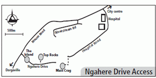
Map
Ngahere Drive is within the boundary of Whangarei City and can be reached by taking Maunu Road from the city centre. Pass the hospital and turn left into Ngahere Drive at the start of Maunu Hill. The Island is on an obvious large traffic island (yes!) part way up the hill. Carry on to a small parking alcove at the top of the hill (opposite where #70 Ngahere Drive would be, this section has been withheld as part of the reserve), where a short track to the Top Rocks leads into the bush on your left (north). Take care to stay on the reserve and out of the private properties that surround it.
To access the Main Crag, cross the road (south) and enter the reserve, and pick up a flagged trail, which goes steeply down for 20 metres, then cuts across the slope to the rocks at the Main Face. Total distance is about 230m, no more than 5 minutes. For some days after rain, this trail can be very slippery, use caution.
Note that previous guides recommended access from Hospital Road. This access should not be used, as it crosses private property, and the current landowner has not provided permission (as of late 2021) for it to be crossed.
Climbers should be aware that even though they are climbing in a reserve, the bush directly above the climbs is on private land, and the track that leads over the top of Groove Wall, the Main Face and Starlight Wall is directly on the reserve/private land boundary. Please be respectful of the owners (no loud noise, rubbish, etc.).
There is no water or camping at any of the outcrops.