Routes
| Reference | Title | Grade | Length | Pro | Quality | Alert | Operations |
|---|---|---|---|---|---|---|---|
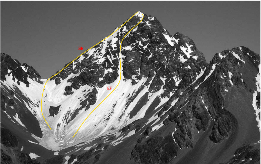
| SR | SRSouth Ridge, 2- | 2- | 0m | ||||
Follow Trojan Stream or Alma Stream, directly to Alma Col and climb loose rock straight up from the col. A bluff near the start of the route can be bypassed by a short, exposed traverse on a narrow ledge west of the ridge, or a rising traverse on loose rock on the east side. Either may require a rope. The south-west face can be used in good snow conditions. |
|||||||
| EF | EFEast Face, 2+ | 2+ | 0m | ||||
From the head of Alma Stream follow a snow gully directly to the summit. Not often in condition. |
|||||||
| North East Ridge, 1+ | 1+ | 0m | |||||
From Alma Stream climb to a prominent col on Alma Spur at 2100 metres, west of Pt 2205 metres. Drop into the valley to the north to avoid gendarmes, then regain the ridge and follow small scree and rock ledges to the summit |
|||||||
| North Face | 0m | ||||||
From Balaclava Basins at the head of The Growler follow a prominent east-trending gut leading through the bluffs to join the North Ridge shortly below the summit. |
|||||||
| West Ridge | 0m | ||||||
From Balaclava Basins at the head of The Growler, take a steep couloir leading to a col on the West Ridge and follow steep but straightforward rock to the summit. |
|||||||
in association with the Canterbury Mountaineering Club
