The Grave–Talbot Pass was the first route to connect the head of the Hollyford River with Milford Sound. Although it was at one stage intended as a return route from Milford after walking the Milford Track, the pass is quite a difficult proposition. Wire ropes were installed above Homer Saddle and on the Esperance side to assist guided parties. Only relics of these remain – although parties sometimes belay from the massive bolts that once fixed the ropes to the rock. Treated as a climb rather than a tramp, this is a superb opportunity to develop essential Darrans skills of good route-finding and confidence on exposed ground. The route is described from west to east. Although this means more height gain, the crux ledges onto the ridge above the upper Esperance are easier to locate. The crossing is a long day – 10–12 hours – and many opt to spend a night in the upper Esperance, especially if using a rope as this will increase times.
The first crossing, from east to west, involved a more direct and frightening route over the top of Mt MacPherson and then directly down to the valley floor from the pass, double-roping using snowgrass as anchors. In January 1911, Grave, Talbot and Bert Lyttle crossed the pass as described below.
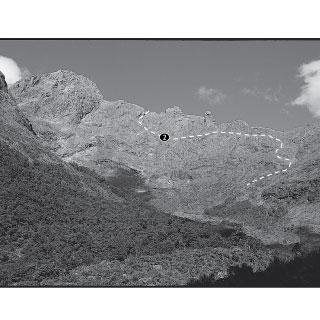
From the Gulliver River bridge on the Milford Road, a good track follows the true left bank to the junction with the Esperance River, where it climbs more steeply at first towards the head of the Esperance. At the bushline, cross a usually dry tributary creek and continue into the main riverbed. Follow the riverbed to the De Lambert Falls, which are best passed on the true right. Above the falls, a small creek bed on the true left leads up towards the lowest point on the ridge.
From the upper Esperance, it’s well worth taking time to identify the route to the pass. A daunting rock monolith bars the way up the ridge itself, but two ledge systems cross the steep face below. The upper ledges begin about 15m below the ridge at a bare patch that sometimes contains water – The Tarn. Follow these narrow ledges east on a gradual descent. This is the most exposed part of the crossing and some parties use a rope, belaying from the wire rope anchors (they are very old – use at your own risk). Directly below the pass is a sloping ledge of slightly paler rock in a dry watercourse. It’s a 240m climb from here, bearing at first to the left and then back right, to the pass (CB08 0186 3293).
From the pass, a level traverse across a snowfield (rock slabs later in summer) leads to a rock stairway that climbs to Lyttles Dip, an obvious notch in the ridge. Beyond the Dip, cross another snowfield (or rock slabs) and then a boulder field, veering left to the ridge and the top of Talbots Ladder. Locating Talbots Ladder can be tricky in poor visibility. Here too, the ancient metal bolts can be used as anchors if necessary on the descent to Homer Saddle.