Edgar Thomson is the northernmost peak of the Ben Ohau Range. Jane Thomson and Conrad Kain claimed the first ascent in 1915 in preparation for their Grand Traverse of Aoraki Mt Cook, undertaken the following year when Thomson was 57. Thomson named the peak after her son Edgar who died from a football injury.
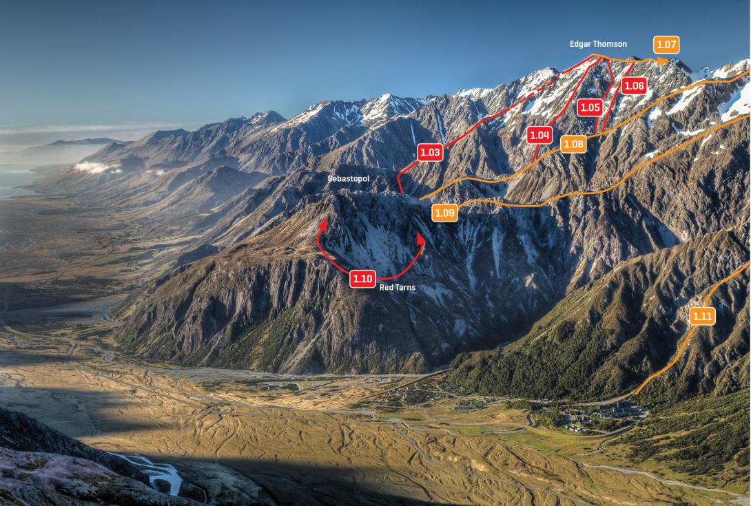
Eastern slopes of the Ben Ohau Range and the Sealy Range, December 2009.
Routes
| Reference | Title | Grade | Length | Pro | Quality | Alert | Operations |
|---|---|---|---|---|---|---|---|
| West Face, III,3+,12 | III,3+,12 | 0m | |||||
|
The base of this route is easily accessible from Jamieson Saddle. Scramble up mainly good, exposed rock on the central pillar of the west buttress leading to the subsidiary south-west peak. Follow the ridge to the main summit.
|
|||||||
| South Ridge, I,1 | I,1 | 0m | |||||
|
Head up Birch Hill Stream to Jamieson Saddle. From the saddle, follow a meandering and pleasant ridge to the summit.
|
|||||||
| South Face, I,2 | I,2 | 0m | |||||
|
Travel up Birch Hill Stream until past the last sub-alpine vegetation, then angle up the steep lower slopes to gain snowfields which are followed to the summit.
|
|||||||
| 1.03 | 1.03East Ridge, I,1+ | I,1+ | 0m | ||||
|
A very enjoyable day trip, often feasible when the Main Divide is clagged in during a north-wester. Travel up lower Hoophorn Stream and head up the second side stream on the true right (at about 1000m). Once above the scrub line, traverse back towards the left on a tussock terrace, and then climb to the saddle near Pt 1488m. From the saddle, climb west up the ridge until a noticeable increase in gradient (at about 1920m). This steep section can be climbed direct, but most people avoid it by sidling out onto the South Face and zig-zagging up on snow fields to re-join the ridge about 100m below the summit. Descend either the same route or the South Ridge.
|
|||||||
| 1.04 | 1.04Central Rib, III,3 | III,3 | 0m | ||||
|
Climb the vague rib on the North East Face that begins in the true right of the upper Hoophorn basin and runs up the centre of the face.
|
|||||||
| 1.05 | 1.05Whiteley Woute, III,2+ | III,2+ | 0m | ||||
|
From the upper reaches of Hoophorn Stream follow a steep snow lead to reach the ridge close to the summit. The first ascent is reputed to have been completed by moonlight after a pub session had concluded the face was overdue an ascent! Not recommended without snow/ice cover.
|
|||||||
| 1.06 | 1.06North East Face Variant, III,3 | III,3 | 0m | ||||
|
Begin at the base of the Whiteley Woute, but instead of following the gully, move right onto a vague rib. Good rock on the lower half, but angles back and becomes more shattered higher up. This route avoids the worst of the avalanche danger, and reaches the ridge about 200m north-west of the summit.
|
|||||||