Lord Range
Routes
| Reference | Title | Grade | Length | Pro | Quality | Alert | Operations |
|---|---|---|---|---|---|---|---|
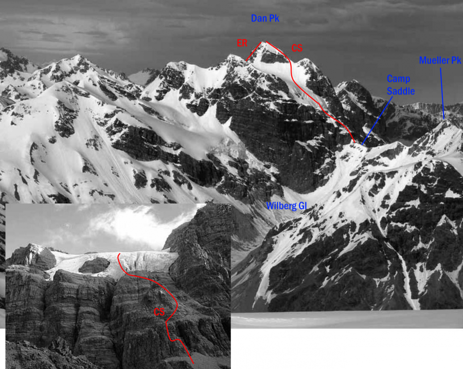
| CS | CSFrom Camp Saddle, 2+ | 2+ | 0m | ||||
At Camp Saddle climb the 20m bluff directly above by gaining access immediately left of a chute, climbing good ledges, then traversing left to the corner of the bluff. Move directly up an exposed solid rock column overlooking the Wilberg Camp Saddle slopes. Ascend snowslopes to beneath the small glacier here, traverse left and ascend steeper slopes to the snowfield above. Another steepish snowslope leads to a narrow saddle between the false and main peak. About 100m remains of easy rock ridge to the summit. |
|||||||
| Lord Range Traverse, III,3+ | III,3+ | 0m | |||||
|
From a camp near pk 1994, traverse NE on glaciers, gaining the ridge at the pk 2140 -2275 col. Generally follow the ridge on loose rock from here to Dan Peak. Mainly scrambling with some hard scrambling/low-grade rockclimbing. The cruxes are the looseness of the rock, and an abseil (length not remembered - a 60m rope was carried) into the notch / col either before 2293 or Dan Peak. Descend via Camp saddle route, follow downvalley Westward towards Poker Gully, but then take the couloir up towards pt 1983, and slowly back to camp on broken schist boulders. Water is scarce and travel is slow in the rocky Southern parts of the range - shattered schist boulderfields and rifts predominate. A full traverse of the range, carrying on Northwards of Dan Peak, remains undone, but the rock quality is offputting. A winter traverse, and/or traversing E-W (although the gendarme near .2293 a major obstacle; very steep) might be considered.
|
|||||||
| ER | EREast Ridge, 2+ | 2+ | 0m | ||||
A variation from the upper snowfield east of Dan Peak itself is the steep rocky East Ridge on the crest of the Lord Range itself. However, the rock is 'deteriorated'. This was used as a descent route back to the upper snowfield by |
|||||||
in association with the Canterbury Mountaineering Club
