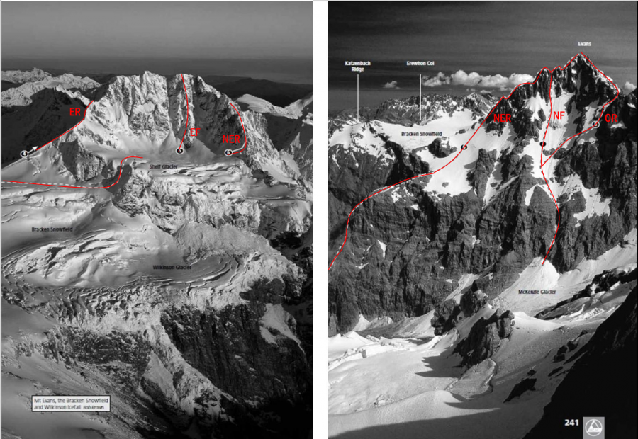
Mt Evans stands dominant at the head of the Wanganui, Waitaha, and Whitcombe valleys, while the Bracken Snowfield to the south-east, at or above 2000 metres altitude, looks into the Wanganui, Rakaia and Whitcombe valleys.
Reach the Shelf Glacier via a narrow gully direct from the Bracken between 2100 and 2200
metres. The East Face is quite a feature despite its relatively small dimensions. Climb the rib
(obvious from other peaks in the region but less so from below) generally on or near the crest
to the low peak at 2609 metres. The first ascent gave sustained and tenuous climbing in deep
snow, with occasional ice strands through rock bands. Descent was by the big gully in the
middle of the face (which may be the quickest and most direct route up the mountain, snow
conditions allowing). In summer this gully is subject to rock fall. Other lines on the face remain
to be climbed
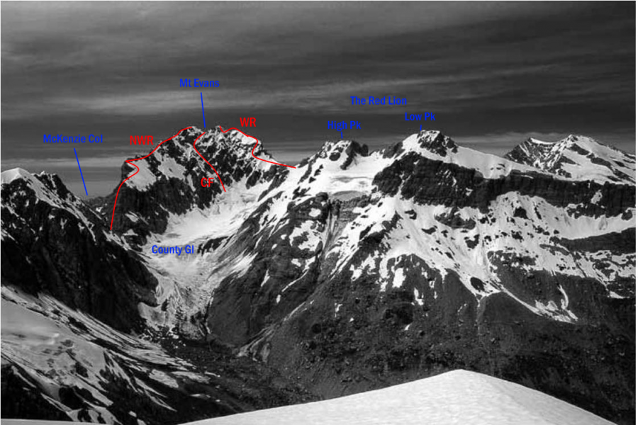
Gain Red Lion Col and then cross shingle and find a line through the bluffs in
gullies on the County side. Above, long easier snow slopes lead up the ridge. The ridge then
narrows, offering an exposed scramble on snow or very loose rock to the summit. This summit
ridge (called the Southern Cornice in past accounts) can be tricky under snow, with significant
cornices.
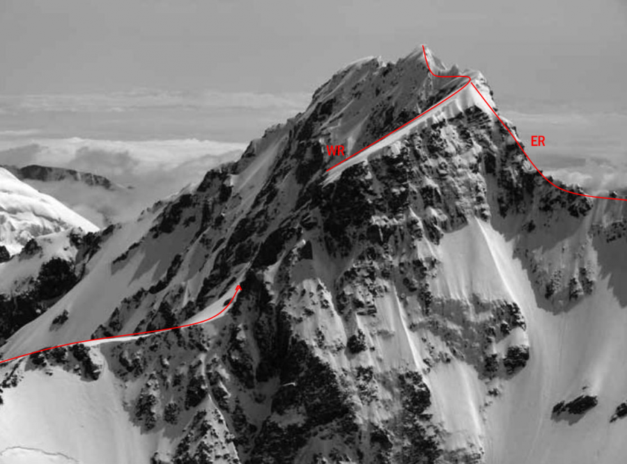
This route offers a direct approach from the Bracken Snowfield, though the rock is quite poor in
places. A snow arête gives way to a narrow ridge of loose rock and pinnacles, another snow arête
and then some gendarmes. A variation, keeping to snow on the south side before the crux, has
also been used. The section from the East Ridge up steep, loose rock flanks to the West Ridge
is normally the crux.
A classic route. Reach the Shelf Glacier from the Bracken as described in East Face.
Alternatively, from the Wilkinson Valley, climb the lower section of the ridge keeping to the
McKenzie Glacier side. There are five rock steps and gendarmes, mainly on firm rock, and where
the climbing becomes too severe alternatives usually exist on the McKenzie Glacier side. The
final rock section leads to the junction with the North West Ridge and a traverse over the north
summit to reach the high peak.
A variation climbs up the North Face, reaching the North East Ridge high up. ‘Good rock
climbing in places on the North Face. Very loose rock to the summit and off.’
Access to MacKenzie Col is best from the Wilkinson side, earlier in the season. On the County
side the couloir is narrow and more subject to rock fall.
Begin up steep and fairly rotten rock, passing a prominent finger of rock on the McKenzie
side and a rock tower on the County side. Three rock steps are more challenging, particularly
the second one. Less than 100 metres from the junction with the North East Ridge, the ridge
steepens and the first ascent party was forced to bypass this up a snow gully to the climber’s
right. Loose rock leads to the high peak (or sidle well down on steep snow to avoid cornices).
From the upper County névé, negotiate big schrunds to access the main gully at about
J34 411783 / BW18 311 167. Generally the route follows up the middle of the face with a mix of
loose and reasonable rock, snow patches and a long snow couloir between two rock ribs. Loose
rock to the right completes the climb, reaching the summit ridge about 30 metres left of the
high peak. Not excessively difficult climbing but sustained and moderately exposed. The route
has variable greywacke, best approached when there is still snow in the gullies.
From the NZAJ Archive:
THE RECONNAISSANCE OF MT. EVANS.
Sir,—In the May, 1932, issue of N.Z.A.J. (No. 19, p. 25) I wrote concerning an attempt at the then virgin Mt. Evans by the East ridge route. I stated, "we climbed to 8,200 odd feet on a route that at last resolved itself into certain impossibility.” Looking at that statement in the colder light of historical perspective, I realise that, in general, nothing is impossible in the Southern Alps, and that in particular the East ridge route to the Southern Cornice (low 8,580ft. Evans Peak) may one day be completed, especially if piton technique in this country ever becomes perfected. I will be glad if you will allow me this opportunity to publish that while I do not consider the completion of the East ridge to be an impossible feat, it would never-theless be an undertaking of difficulty to be made with extreme caution, even in perfect conditions. I would not advise parties to use the East ridge route because of the danger area under the Southern Cornice, but it is only fair that I should acknowledge my mistake in referring to that route as being one of certain impossibility.
Yours, etc.,
J. D. PASCOE.