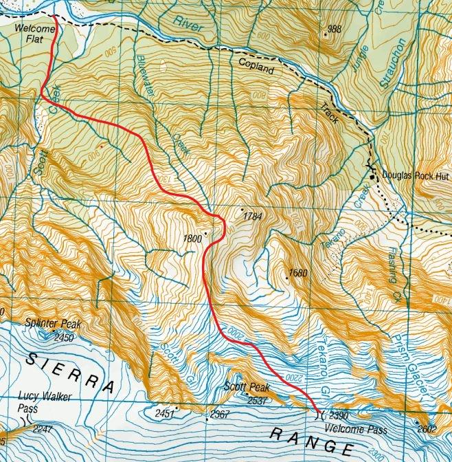
This is currently the recommended route to Welcome Pass, as it avoids the
waterfalls of the Scott Creek Route and involves a pleasant variety of bush,
tussock, rock, and snow travel. A route has been cut and marked all the way
from Scott Creek to the bushline. It was easy to follow in early 2016, and has been newly recut and marked with white permalat markers with a red strip in the summer of 2022/23. (A pair of loppers is left in the bush at the top end if more bush cutting is required).
Care should be taken to find the beginning of the route. It begins on a
bush-covered terrace 20m above Scott Creek on the true right bank, at about
580m, where a small stream (shown on the topomap) flows across the terrace.
This is referred to here as ‘Point A’ and is roughly located at about
BX15 563 631. The stream enters Scott Creek on the true right below a massive, moss-covered boulder. Depending on conditions, it might be possible to follow the creek up to Point A.
Access to Point A from the Scott Creek bed varies seasonally due to massive
avalanches in winter and spring that modify the shape of the creek bed and
its high, steep bank. The marked route begins from a small open
terrace 20m further upstream at about 600m – two cairns mark the route out of Scott Creek and onto the terrace. Permalat markers start on the upper end of the terrace, and a large white permalat X marks the start of the track at the top of the terrace. From there the track loops back on itself and goes back down to Point A. In summer 2022 the track is very well marked in both directions, freshly cut, and easily identifiable.
From Point A, on the true right of the side stream, the route climbs steeply,
veering away from the stream with increasing height. Stick to the marked
route. Good travel up through rata/podocarp forest, and then mountain
neinei/dracophyllum forest leads to the bushline at 1080m. At 1140m,
there’s a two-minute detour to a spectacular viewpoint over the Bluewater
basin. The marked route continues to the top of the scrub at 1300m with warratahs, and then cairns that follow up the obvious slide that goes straight to the bottom of the cliffs of point 1800.
Follow animal trails along the base
of the prominent cliffs. This leads to the final basin below the saddle
between Pt 1800m and Pt 1784m (Bluewater Saddle), which is reached via gravel
slopes and rock ledges.
From Bluewater Saddle, drop 20m on the Tekano side, and then traverse and
climb back onto the ridge south of Pt 1800m. Follow this ridge south for
about one kilometre, and then ascend on a rising traverse across the Tekano
névé – watch for crevasses and soft afternoon snow – to Welcome Pass.
In the reverse direction: when descending below the bluffs, if you overshoot
the large boulder at 1300m [BX15 573 622], you should encounter an old slip
with regenerating scrub which leads into the stream marked on the map
beginning at about BX15 572 624. This can be followed down to about 860m,
where there is a short section of pink tape that leads away from the stream
back to the main Bluewater Route. There is a small flat in this stream at
about 900m which is large enough for one tent.
The Bluewater Route through the bush has been used by hunters for some time.
The first recorded use of the full route as a descent from Welcome Pass was
by Danilo Hegg and George O’Sullivan, Jan 2010. The first recorded climb of
Mt Sefton using this route was by Nina Dickerhof and James Thornton in Nov
2015