Summit climbs from Kahui Road

Type

Kahui Road is located on the western side of the mountain.
Accommodation
Kahui Hut
Operated by DoC and situated just below the bush line at an altitude of 880m, Kahui Hut has bunks for 6 people and water. Access from the end of Kahui Road at the park boundary requires a walk of approximately 2 hours. Kahui Hut offers the only accommodation for climbing on the west side of the mountain and affords excellent sunset views of the coast and the mountain.

Image
Lat/lon
POINT (173.952198 -39.304749)
Access

If travelling north from Hawera, travel west along ‘Surf Highway’ State Highway 45 to Manaia, 15km and turn right onto Manaia Road. Follow Manaia Road to Kaponga, 14km, and turn left onto Eltham Road. After 10km turn right onto Oeo Road and at the next intersection, 2km take the second road from the left, Wiremu Road. Turn right onto Upper Kahui Road after 20km. Follow this road to the park boundary, 4.5km, approximately 66km from Hawera.
When travelling south from New Plymouth, follow State Highway 45 to Okato, 26km. Drive straight ahead at the roundabout in the centre of Okato onto Old South Road and turn left onto Oxford Road. After 4km turn right onto Saunders Road and then onto Wiremu Road after a further 2km. Turn left onto Upper Kahui Road, after 9km. Follow this road to the park boundary, 4.5km, approximately 46km from New Plymouth.
Add Place Add Route

Routes

Reference Title Grade Length Pro Quality Operations
5.01 5.01Okahu Gorge, 1 1
0

  • P1
  • Alpine (Mt Cook) 1

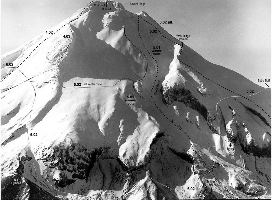
From Kahui Hut the summit track starts just above the hut some 40-50m along the track to Holly Hut. Follow the summit track along a scrub-covered ridge to exit onto a large alpine meadow near Black Rock at 1200m. Continue up the moss slopes marked by occasional poles and rock cairns, towards the summit and follow the gorge to the summit. In summer conditions better footing is available to the north on a ridge above the gorge. Descent: Return down the gorge and track from Black Rock. ‡ A pole on a col at the upper end of Turehu Hill at 1420m should be ignored as it does not mark the route to the summit. Route finding on the descent is difficult when visibility is low. To find the track in these conditions it is easier to continue south across the meadow until the edge is reached and then follow the edge of the scrubline down and north until the track is located.


5.02 5.02West Ridge via Hughsons Ledge, 1+ 1+
0

  • P1
  • Alpine (Mt Cook) 1+

From Kahui Hut descend Kahui Track for approximately 100m and then descend into the Okahu River. Follow the river to Maru on the north and Skeets Slide to the south, below the completely eroded Pakihere Pa. Climb the southern slopes to gain a long, narrow, sloping terrace, Hughsons Ledge, which breaks the main cliff of West Ridge at 1500m. Carefully negotiate a slip face near the top of the ledge and proceed up the slope to the shoulder of West Ridge at 2200m. A distinct point is formed at the junction of West and Bobs Ridges and from here one can descend into the Okahu Gorge and follow the valley to the crater or continue up the West Ridge. A short distance up from the base of the bluffs at 2300m a ledge provides an interesting access into the top of Okahu Gorge. The more adventurous can ascend the bluffs above. When topping out on the crater rim 2440m, continue towards Sharks Tooth to find a suitable descent into the crater. Descent: Return down the Okahu Gorge and track from Black Rock. ‡ While the route description was the original route for access to Hughsons Ledge, it is far quicker to follow the Okahu Gorge route and traverse the moss slopes to ascend a gully adjacent to a spring at approximately 1730m.


Comments
Attribution
Eden, Ross. Taranaki Mount Egmont; A guide for climbers. NZAC, 2003.
UUID
 
faaacb69-6d58-4cbe-b3e5-36ee4f544aeb