Summit climbs from Dawson Falls

Type

Dawson Falls is on the South East side of the mountain. The alpine climbs are listed in this section.
Accommodation
Konini Lodge
Operated by DoC and situated below the Dawson Falls road end at an altitude of 880m, Konini Lodge has bunkroom accommodation for up to 38 people in 6 bunkrooms. It has a fully equipped kitchen, hot and cold running water, showers, drying room and electric heating. Hut passes and tickets are not valid at Konini Lodge and bookings can be made at the Dawson Falls Visitor Centre (DFVC).
Dawson Falls Mountain Lodge
Situated opposite the DFVC at 900m and nestled against the bush, Dawson Falls Mountain Lodge is a fully licensed tourist facility, established in 1896, offering everything from a la carte dining to a hot bath. A shop sells a myriad of goodies from ice creams and chocolate bars to light meals and boasts a warm fireplace. Bookings are essential for this warm and comfortable facility.
Kapuni Lodge
Just above the Visitor’s Centre take the Summit Track to Fanthams Peak. At an approximate altitude of 1365m turn right onto the short Kapuni Lodge track and ascend to the Lodge at 1400m approximately 1hr 15 minutes from DFVC. The Lodge is owned and operated by Mt Egmont Alpine Club and is locked when not in use. Situated on the edge of the Kapuni Gorge, the facility offers excellent vistas south and east. Two bunkrooms sleep 18 people and the Lodge is equipped with wood stove, solar powered lighting, gas cooking, cooking utensils, cutlery and crockery. As the facility is usually locked, bookings are essential and should be made through the Club.
Syme Hut
From Kapuni Lodge continue up the Summit Track for another 1 hr 30 minutes. When the rim of Fanthams Peak is reached, follow the poles west to Syme Hut 1960m. Another set of poles curves north toward the South Entrance of the mountain’s crater. Syme Hut is operated by DoC, has mattresses for up to 10 people and drinking water. Winter conditions can sometimes coat the hut in thick rime and it can even be buried by snow. The door is on the east wall at the north-east corner.

Image
Lat/lon
POINT (174.103518 -39.323542)
Topo50
BJ29 951 467
Access

If traveling north to the mountain, at Hawera travel west along ‘Surf Highway’ State Highway 45 to Manaia and turn right onto Manaia Road. Follow Manaia Road all the way to Dawson Falls, a distance of 45km from Hawera.
When traveling south on State Highway 3, 450m past the second roundabout in Stratford, turn right onto Celia Street which becomes Opunake Road at the town boundary. Approximately 15km from Stratford turn right onto Manaia Road and travel due north to Egmont National Park and Dawson Falls road end at 905m, 23km from Stratford.
Dawson Falls Visitor Centre is well worth a visit with excellent permanent displays, up- to-date information on the tracks and conditions and current weather reports. Maps, handbooks, hut tickets and intentions book are available. A mock-up of old Syme Hut has been erected in the centre and incorporates some original material recovered from the hut.
Add Place Add Route

Routes

Reference Title Grade Length Pro Quality Operations
1.01 1.01South Face, 1- 1-
0

  • P1

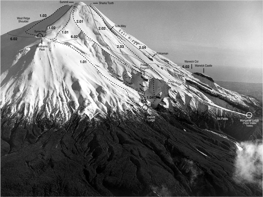
The climb of Taranaki/Mt Egmont from Dawson Falls, via Fanthams Peak is a pleasant summer climb although it involves tedious scoria slopes. In winter it can prove to be icy. The route leaves Dawson Falls on the Summit Track just above the Visitor Centre at 905m. The track climbs up past Hooker Shelter to the junction to Kapuni Lodge at 1365m and at 1460m passes the junction to the Upper Lake Dive track. Continue climbing on snow/scoria above the steps following the poled route over the Knoll 1675m and from there the route follows up the scoria to a small ridge just before a rocky outcrop on the skyline (Copestone). Here the track splits, Fanthams Peak and Syme Hut 1960m, is straight on up past Copestone, the route to the hut is poled across Fanthams Peak and is 10 minutes from the junction. The route to the right heading north above the head of the Kapuni Gorge circumvents Fanthams Peak and Syme Hut and contours onto Rangitoto Flat. From Rangitoto Flat the route is unpoled and continues north directly up the main face to the South Entrance, a low point in the crater rim just west of Mackay Rocks. Terrain is scoria, while winter can produce varied snow and ice conditions, often with extensive rime. From South Entrance the summit dome lies to the north and a number of routes can be used to access the summit at 2518m. The most popular is opposite the Sharks Tooth but the south face of the dome and the rocky outcrop to the west (The Sisters) can provide interesting ice routes in winter. Descent: If returning to Syme Hut is the same, descent from Fanthams Peak is generally via the Kaupokonui Bowl just to the south of the Knoll. The descent of both the main peak to Syme Hut and the upper part of Fanthams Peak can be tedious with rimed snow conditions in winter and is not to be underestimated. Route finding across Rangitoto Flat and Fanthams Peak can be tedious in whiteout conditions. Times: Dawson Falls to Kapuni Lodge Junction – 1 hour, 15 minutes. Kapuni Lodge Junction to Fanthams Peak – 1 hour, 30 minutes. Fanthams Peak to Summit – 1 hour, 30 minutes. Total 4 hours, 15 minutes.


1.02 1.02Skeets Ridge, 1 1
0

  • P1
  • Alpine (Mt Cook) 1

Climb to Syme Hut as per the South Face route. From Syme descend onto western edge of Rangitoto Flat and sidle west to gain Skeets Ridge. Follow the ridge directly to the crater rim. Alternatively, take the Upper Lake Dive Track at 1460m and continue around Fanthams Peak until the Punehu Stream is encountered, which flows between Fanthams Peak and the main cone of the mountain. The track skirts the top of the Punehu Gorge which is the highest point on the Around the Mountain Circuit at 1540m. Skeets Ridge is 100m to the west and can be easily gained and followed to the summit. Descent: Via the South Face route.


1.03 1.03Bobs Ridge, 1+ 1+
0

  • P1
  • Alpine (Mt Cook) 1+

Climb to Syme Hut as per the South Face route. From Syme descend onto Rangitoto Flat and traverse to the west and gain the ridge directly above Bobs Bluff at 2000m. Follow the ridge up to the shoulder of West Ridge at 2200m. A distinct point is formed at the junction of West and Bobs Ridges. From here one can descend into the Okahu Gorge and follow the valley to the crater or continue up the West Ridge. A short distance up from the base of the bluffs at 2300m a ledge provides an interesting access into the top of Okahu Gorge. The more adventurous can ascend the bluffs above. When topping out on the crater rim 2440m, continue towards Sharks Tooth to find a suitable descent into the crater Alternatively, take the Upper Lake Dive Track at 1460m and continue around Fanthams Peak until the Mangahume Stream is encountered at 1400m. The track descends into a narrow steep sided gorge and Bobs Ridge forms the west side of the gorge. A short scramble through the scrub on to the ridge gives access to Bobs Knob 1780m. Follow the ridge to the base of Bobs Bluff 1850m and climb the 55 metre high, grade 14, Nose route. Follow the top of the bluff to gain the ridge up to the shoulder of West Ridge. Continue on as above. Descent: Via the South Face route.


1.04 1.04Traversing Kapuni Gorge from Fanthams Peak to Curtis Ridge
0

  • P1

Descend into the gorge just below the Knoll (1675m) and follow the eroded slide to the bottom. The base of the gorge is clean rock and access in and out varies. Scramble up the bank and onto the scoria slope. Then climb in an easterly direction until the small spur leading north is gained. The bottom end of the spur is bluffed and a couple of traverses may be necessary in order to gain enough height to avoid these bluffs. Follow this spur in a northerly direction until Curtis Ridge proper is gained, just below the Priests Fingers at 1580m. From here the Curtis Track leads back to Stratford Plateau. There are no huts on the route, although Kapuni Lodge is easily gained from the Knoll. This route is unmarked and parties need to be familiar with it in poor visibility. Approximate time from the Knoll to the Stratford Plateau: 2 hours.


Comments
Attribution
Eden, Ross. Taranaki Mount Egmont; A guide for climbers. NZAC, 2003.
UUID
 
4c6a2bad-836d-4895-a924-aa8c50dbfc31