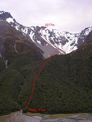
Type Mountain Altitude 2277m Part of Huxley Range Map Lat/lon-44.151203916,169.599949735, NZ Topo Map Topo50 BZ14 281 057 Image Routes Reference Title Grade Length Pro Quality Alert Operations From Hagens Hut 0 Rate From 200m south of Hagens Hut travel through the beech forest following a spur near Plughole Creek to reach the head of valley and climb couloir to the summit. Add Place Add Route Log in to post comments Comments UUID 1fa99d3b-af2d-45ae-a461-9451bda1b880