Map
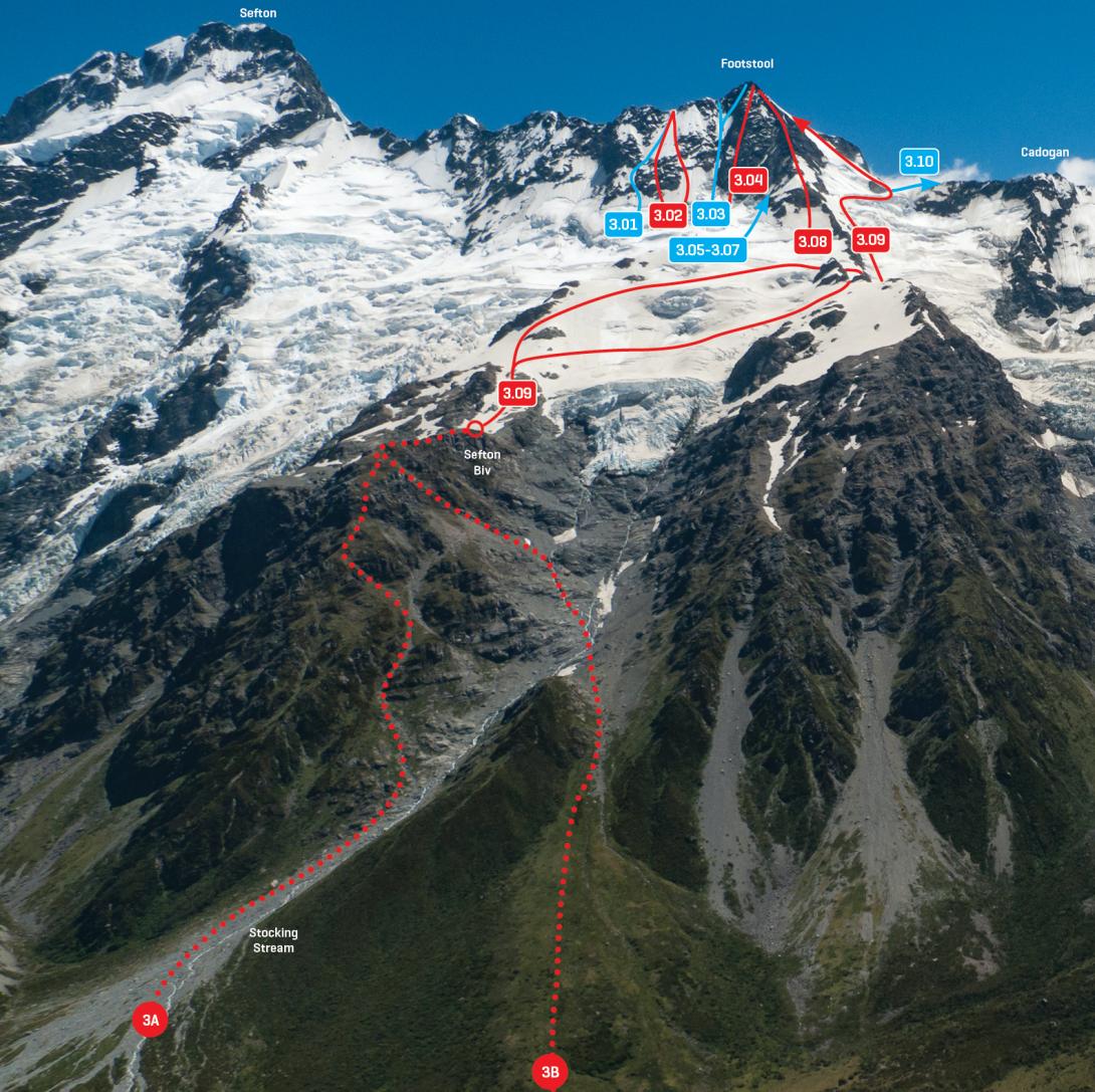
Routes
| Reference | Title | Grade | Length | Pro | Quality | Alert | Operations |
|---|---|---|---|---|---|---|---|
| 3.01 | 3.01Requiem for a Dream, III,3+ | III,3+ | 300m | ||||
|
More than a variation, as the gully is a distinct feature. From the bergschrund at the base of the east face, climb snow and ice gullies 200m left of the main couloir. One pitch going left, then three pitches going right in a series of gullies to reach the ridge.
|
|||||||
| 3.02 | 3.02Wombats on Heat, III,3+ | III,3+ | 300m | ||||
|
Ascend a weakness through the rock band below the large snowfield, then up to the Main Divide south of The Footstool. There is a variation that links snowfields to the right of the rock band. This is a good alternative to the Couloir Route if the bergschrund conditions are not favourable. During late summer, snow can be completely absent from this face, and the rock is not worth climbing!
|
|||||||
| 3.03 | 3.03Couloir Route, III,3+ | III,3+ | 300m | ||||
|
From the Tewaewae Glacier ascend the prominent couloir either to the south ridge, or near the summit move right up an offshoot couloir. The bergschrund at the base of the couloir is often troublesome; this route is usually cut off after early summer.
|
|||||||
| 3.04 | 3.04Direct, III,4 | III,4 | 0m | ||||
|
Follow the face to the right of the Couloir Route via a shallow gully.
|
|||||||
| 3.05 | 3.05Footstolen, II,3+ | II,3+ | 0m | ||||
|
A short ice route to the right of the Direct, joining the east ridge.
|
|||||||
| 3.06 | 3.06Infoleak, II,3+ | II,3+ | 0m | ||||
|
A short ice route that joins the east ridge.
|
|||||||
| 3.07 | 3.07Smash ’n Grab, II,4 | II,4 | 0m | ||||
|
The right-most of three short ice routes, joining the east ridge.
|
|||||||
| 3.08 | 3.08East Ridge, II,3 | II,3 | 0m | ||||
|
From Sefton Bivvy ascend the Tewaewae Glacier and cross northwards to gain the ridge where it rises from a level section. Follow the ridge directly to the summit. The rock is a big heap of loosely stacked plates; avoid unless you enjoy self-torment, or it is snow covered.
|
|||||||
| 3.09 | 3.09Main Divide, II,2+ | II,2+ | 0m | ||||
|
A popular route to one of the best viewpoints in the region. From Sefton Bivvy, ascend the Tewaewae Glacier and traverse northwards to cross the East Ridge at the level section, then work up the slopes of the Eugenie Glacier to reach the Main Divide. There are often large crevasses on the Eugenie. Once on the Divide, follow up the north-east snowslopes to the summit. There is often a small step right at the top. This is the regular descent route.
|
|||||||
| North Neve, 2 | 2 | 0m | |||||
A route exists from the névé south of the Copland Pass and connects snowslopes on the west to reach the col north of the peak, then as for Main Divide Route . The ridge from the Copland Pass has also been traversed. |
|||||||