Permission is required to cross private land. Log in for contact details.
- Home
- NZ
- South Island
- Nelson Lakes Kaikōura
- Inland Kaikōura Range
- Tapuae-o-Uenuku
Tapuae-o-Uenuku
Tapuae-o-Uenuku is the highest point in New Zealand north of the Aoraki Mount Cook region.
Routes
| Reference | Title | Grade | Length | Pro | Quality | Alert | Operations |
|---|---|---|---|---|---|---|---|
| South Ridge | |||||||
|
Up from the Hodder. |
|||||||
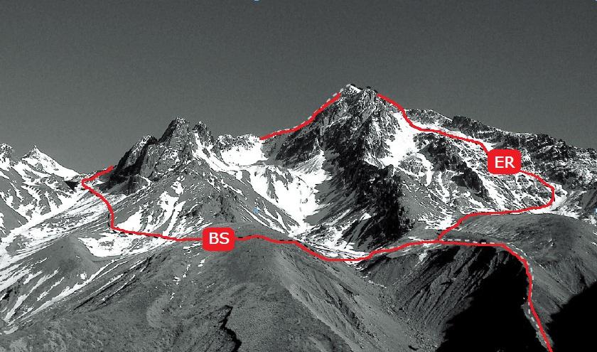
| BS | BSBranch Stream Route, 2 | 2 | 0m | ||||
Via Clarence Valley. Park your 4WD vehicle near fertiliser bins at 640m at an airstrip near Branch Cottage. Head west to a tributary of Branch Stream, follow an old farm track, then ascend a tussock slope with regenerating totara to gain a scree ridge on the true left of Branch Stream. At about 1450m, before the first rocky knobs on ridge, descend a large scree slope to the stream. Alternatively, sidle at about 1300m to the scree slope. Then climb a tussock ridge, heading north-west, and sidle into a good campsite at 1500m (map ref. O30/671108). Follow the gully and couloir at its head onto the south-west ridge, thence the normal Staircase Stream routes to the summit. (NB: don't descend the ridge between central and southern branches of Branch Stream - it ends in steep cliffs, or is guarded by dense scrub). |
|||||||
| ER | EREast Ridge, 2 | 2 | 0m | ||||
Via Clarence Valley. From the campsite of Branch Stream route , sidle an easy spur, into another campsite at about 1580m in the next tributary to the north. From a high basin east of the summit climb a steep couloir through bluffs and onto the summit slopes. |
|||||||
| Dee Stream Route, 1 | 1 | 0m | |||||
Via Clarence Valley. Go upstream through a patch of beech forest and past bluffs to a spur, which leads westwards to the summit slopes of East Ridge route. This spur can also be reached from the Branch Stream routes. |
|||||||
| Staircase Stream Routes, 2 | 2 | 0m | |||||
Via HODDER RV. ‘Tappy’ is mostly rock and scree in summer, when foot trails and occasional cairns mark the route. In winter this route is not technically difficult, but it's still a big climb. From the huts follow the terrace and then across scree to the junction with Staircase Stream. Keep to the true right of Staircase Stream, across terraces, to the waterfall creek. Continue up easy slopes towards the saddle between Alarm and Tapuae-o-Uenuku, then head east, angling left under a rocky peak 2711m and up the south-west ridge to the summit. An alternative is to sidle into a basin above the waterfall and then into the basin north-west of the summit. Climb from the head of the basin to the north ridge, or else directly south-west to the top. Descend the same way, or follow the north ridge and drop down a gully just before Pinnacle (2720m). |
|||||||
| TS | TSTongue Spur, 2 | 2 | 0m | ||||
Via HODDER RV. The spur is easily gained from the Hodder at a low saddle. Bypass Pinnacle by a traverse (on either side). A long route. |
|||||||
| The Ornery Goat, 4 | 4 | 0m | |||||
|
Start up deep gully in center of the south face. Two pitches to the hanging
|
|||||||
| -41.99927, 173.6653 | -41.99927, 173.6653The notch, 2 | 2 | 0m | ||||
|
Climb into the valley below the south face. Look for the prominent gully
|
|||||||
photo Rob Suisted, naturepics.com
