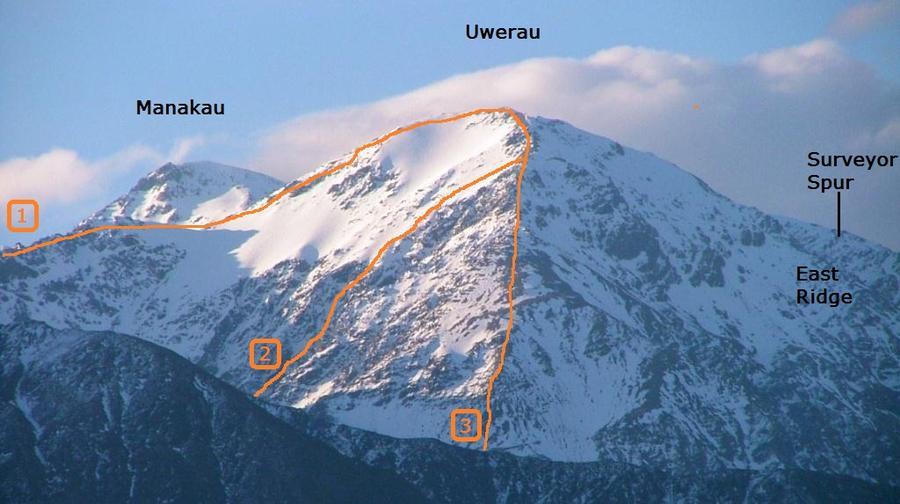
Reputedly first climbed in March 1929 by Ted Brown, a musterer, who did a bold traverse in a single day from the Clarence Valley, over Manakau, Uwerau and Mt Fyffe to attend a party in Kaikōura. Legend has it he returned via the same route the following day to pick up his dog from high on the slopes of Manakau, where it had refused to go any further.
Routes
| Reference | Title | Grade | Length | Pro | Quality | Alert | Operations |
|---|---|---|---|---|---|---|---|
| 1 | 1Middle Spur Route, II,2+ | II,2+ | 0m | ||||
|
The long ridge at the junction of Kowhai River and Kowhai Saddle Stream (known locally as Middle Spur) is initially easy scrub and tussock, later becoming a mix of scree, broken rock and gendarmes. It is possible to gain the spur from Kowhai Saddle, but steep broken rock must be crossed.
|
|||||||
| Kowhai River Route, II,1+ | II,1+ | 0m | |||||
|
Reach the upper Kowhai River by climbing the South Ridge of Mt Saunders to the razorback. Sidle this, and continue to sidle animal tracks through scree and tussock above the river, then descend past ribbonwood to a major stream off the south-west slopes of Mt Saunders. Cross the stream and climb to a prominent ribbonwood flat (O31 593 820 / BT27 493 203), which descends to the river above a 10m waterfall. Cross the river, climb up to a tussock and scrub terrace, and follow this for about 400m till a descent into the open upper valley is possible. Scree can be climbed from the headwaters to a saddle at 2140m on the Uwerau to Manakau ridge. Fair scrambling, occasionally steep, leads to either peak. Considerably longer route than the usual routes.
Access via KOWAI RIVER |
|||||||
| 2 | 2South West Face, II,3 | II,3 | 0m | ||||
|
This route has been climbed in winter, but it is necessary to avoid gorges and waterfalls in the Hapuku River headwaters by a high level traverse from the normal Hapuku Route.
|
|||||||
| 3 | 3Hapuku Route, I,1+ | I,1+ | 0m | ||||
|
From Hapuku Hut cross the Hapuku River and follow the track upriver to a small creek, just before the track enters the riverbed (O31 625 813 / BT27 525 196). Follow the creek up till it starts to open out and climb onto a tussock spur on the true right, which leads through easy scrub to scree and to the summit. Take care when descending Uwerau to avoid the spurs further eastwards, which have a belt of thick subalpine scrub.
Via HAPUKU RIVRER |
|||||||
Photo Clayton Garbes

change