Type
Altitude
149m
Part of
This crag suffered damage during the 22 February earthquake and should be avoided (see comment below).
Walktime
10 min
Aspect
West
Lat/lon
-43.583202,172.762126, NZ Topo Map
Topo50
BX24 808 744
Approach
From Evans Pass drive 1.2 km towards Godley Head. Park at the obvious lay by, walk 100m further along the road and then straight down the spur for 4–5 minutes.
Routes
| Reference | Title | Grade | Length | Pro | Quality | Alert | Operations |
|---|---|---|---|---|---|---|---|
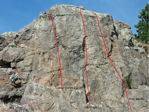
| Four blokes on a spoke, 16 | 16 | 2 |
|||||
|
The corner/crack on the highest buttress mass. 2 bolts and natural pro.
|
|||||||
| Third age, 21 | 21 | 3 |
|||||
|
Reddish wall 5 metres right of 4 blokes. 3 bolts.
|
|||||||
| Polar Bandit, 17 | 17 | 3 |
|||||
|
Two metres right of TA. 3 bolts and natural pro.
Two metres right of TA. |
|||||||
| Rhythm Hitches, 18 | 18 | 2 |
|||||
|
Shallow groove/corner 3 metres right of PB. 2 bolts, natural pro, chain
|
|||||||
| Public Enemy, 18 | 18 | ||||||
|
the loose flakes
|
|||||||
| Powervacum, 18 | 18 | 1 |
|||||
6 metres right again. Small overhang. |
|||||||
Comments
UUID
f62dc980-cb80-4d20-b40b-8a74c5b4dd45

Currently this area should be regarded as closed and dangerous due to the quake. It is rumoured to be teetering tilted and bolts and blocks have fallen out.We will be working in that area shortly so should have more details. 4/4/11 Simon M
The 4 routes from the left appear unaffected by the quake but the next 2 are totalled.Photo's to come.