Kaimata Range
Routes
| Reference | Title | Grade | Length | Pro | Quality | Alert | Operations |
|---|---|---|---|---|---|---|---|
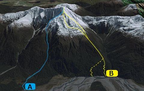
| A | ATaramakau Gully/ South Face, 1+ | 1+ | 0m | ||||
Cross the Taraakau River opposite Rocky Creek. Bah through the easy scrub and swamp to meet the obvious rock gut that cuts a swath south face.. The steep gut has several waterfalls and cliffs which have greasy by-passes, be careful!. Halfway up the route a major fork is met. To follow the true left you will meet a overhung rock choke, which may be possible if you are fearless. Alternativley climb out the gut prior to the fork on its true right, climbing on shrubby ground to join up with an easy rock ridge. This ridge merges into scree slopes, followed by a series of easy gullies and scrambles to the summit |
|||||||
| B | BSE Ridge, 1+ | 1+ | 0m | ||||
There is no easy way to approach this ridge, the full flow of the Taramakau River (includes the Otira River) must be crossed in one or two channels, then a west coast scrub bash ensues to gain the upper ridge, from either the true right spur adjacent the creek draining the Mt Howe basin, or an obvious diagonal fault scarp about 200m further downstream. Either way there tends to be some steep, slippery terrain hidden in the beech forest. Once treeline is reached travel along the wide open ridge is easy. Steepening rock is encountered about 300m short of the summit, in winter the snow/ice allows fairly easy travel (beware of cornices!), in summer expect loose, gruddy rock. An alternative is to track west under the ridge rocks using a series of interlinked scree/snow gullies that lead to the summit, this makes an easier descent route (take care in winter as these are also avalanche paths). |
|||||||