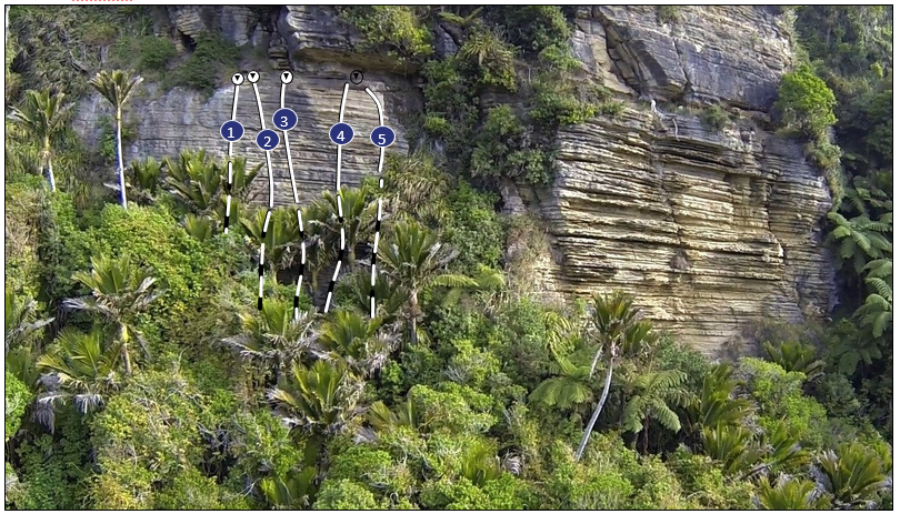
Pita Pata Wall is hidden in the bush high up above the Punakaiki River. It was developed in desperation on a rainy day - Bullock Creek was flooded and most other areas of rock were wet. It’s a wee walk up to the crag, but it stays dry in any weather and the views out to sea are stunning!
Park just before the 2nd gate. Head right up through a grassy clearing and look for a marked track in the bush. Cross under a wire and up to the base of a chossy cliff. Follow this around to Pitapata Wall.
Routes
| Reference | Title | Grade | Length | Pro | Quality | Alert | Operations |
|---|---|---|---|---|---|---|---|
| 1 | 1Rain Dance, 16 | 16 | 12m | 4 |
|||
Cruise from jug to jug up past three bolts to a spicy finish. |
|||||||
| 2 | 2Gumboot Route, 15 | 15 | 12m | 6 |
|||
The name is a reference to the first ascent footwear. |
|||||||
| 3 | 3The Darkness Comes, 17 | 17 | 14m | 6 |
|||
Sustained climbing on featured rock. |
|||||||
| 4 | 4Inspiration Exploration, 17 | 17 | 14m | 6 |
|||
Pumpy moves to gain an easy face. |
|||||||
| 5 | 5Pitta Patta, 16 | 16 | 14m | 6 |
|||
Bridge up the right-hand corner through a couple of steep moves to easier climbing after the bulge. |
|||||||
