It's best to go when it has been dry for at least a few days and there is no mist on Mt Cargill. It's worth taking a second rope so that you can abseil to the base of the crag. There is a rough track to the bottom of the crag (standing at the top looking out to your right) and one through the gully between the back wall and main crag. The right-hand anchor, seen as you walk down towards the crag, is the easiest for descent. A carpet square or a towel might come in handy if conditions are damp.
Mostly fully-bolted sport routes between grade 15-20: https://www.facebook.com/media/set/?set=a.313160255814.184803.208069165814&type=3
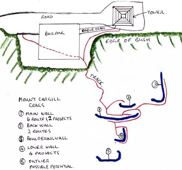
Topo. here: https://www.facebook.com/media/set/?set=a.313160255814.184803.208069165814&type=3
Some background on Mt. Cargill: http://en.wikipedia.org/wiki/Mount_Cargill

About 15 minutes drive from the city centre, via Pine Hill Road and Cowan Road. Park by the tower and walk about 2-5 minutes down a rough track on the far side (from the road) of the building.
Routes
| Reference | Title | Grade | Length | Pro | Quality | Alert | Operations |
|---|---|---|---|---|---|---|---|
| 3 | 3Callow Youth, 17 | 17 | 4 |
||||
|
|||||||
| 4 | 4Und Du Bist Mein Sofa, 20 | 20 | |||||
|
|||||||
| 5 | 5Can Yer Mammy Sew?, 20 | 20 | |||||
|
|||||||
| 6 | 6Luke Here Jimmy, 19 | 19 | |||||
|
|||||||
| 9 | 9Tatty Bogle, 19 | 19 | 15m | 3 |
|||
|
|||||||
| 10 | 10Sunrise Redeemer, 19 | 19 | 15m | 3 |
|||
|
|||||||
| 11 | 11Charlie Banali, 15 | 15 | |||||
|
|||||||
| 12 | 12Wistful with a Fistful, 16 | 16 | 10m | ||||
|
|||||||
| 13 | 13Friendly Little Finger, 18 | 18 | |||||
|
|||||||
| 1 | 1Pegasus | 18m | 6 |
||||
The left-most climb (from the bottom looking up) on the main crag. Like most of the climbs on this face, it is a slab climb requiring trusting footholds. Crux is at the third bolt. |
|||||||
| 2 | 2Take No Prisoners, 18 | 18 | 18m | 6 |
|||
To the right of Pegasus. The crux is at the third bold. Can be made easier by stepping left at this point. Nice slab moves requiring balance. |
|||||||
| 7 | 7No Epistemic Vices, 21 | 21 | 15m | 6 |
|||
|
Through the overhanging scoop and up. Crux is getting off the ground and to the second bolt. Then nice slab moves follow. Can be used as a harder direct start to 'Luke Here Jimmy'
|
|||||||
| 8 | 8unknowen? | ||||||
Images


Over the summer (2022/23) three new climbs have been added, some climbs have been cleaned, and tracks have been re-marked with red tape.