Permission is required to cross private land. Log in for contact details.
- Home
- NZ
- South Island
- Nelson Lakes Kaikōura
- Seaward Kaikōura Range
- Te Ao Whekere
Te Ao Whekere
The second highest peak of the Seaward Kaikōura Range and a good winter climb.
North of Kaikōura, turn off SH1 onto Puhi Puhi Rd on the north bank of the Hapuku River bridge. The shortest route is from Happy Valley but permission must be obtained to cross Puhi Peaks Station land.
Log in to view access information.
Routes
| Reference | Title | Grade | Length | Pro | Quality | Alert | Operations |
|---|---|---|---|---|---|---|---|
| Jordan Stream Route, II,1- | II,1- | 2300m | |||||
|
Follow Jordan Stream to the major fork, and continue up the true left branch till at 700m where the stream swings west. Just upstream of the 700m contour, look for a scree that goes most of the way down to the true left branch, climb this onto the major spur running north-west. The spur levels at 1500m, where there are campsites, with water in the head of Range Stream. Continue to the tops surrounding the head of Happy Valley Stream, follow around the rim and north to the summit. A long but straightforward route.
|
|||||||
| Totaranui Route, II,1- | II,1- | 2200m | |||||
|
The major spur of the Jordan Stream Route can also be joined at around 1400m by following spurs from Totaranui Farm on Puhi Puhi Rd. The spur levels at 1500m, where there are campsites, with water in the head of Range Stream. Continue to the tops surrounding the head of Happy Valley Stream, follow around the rim and north to the summit. A long but straightforward route. Request permission from Brent Barber, phone 027 272 6315.
|
|||||||
| Happy Valley Route, II,1 | II,1 | 2000m | |||||
|
Happy Valley is reached via Puhi Peaks Station and permission is required to cross their land.
|
|||||||
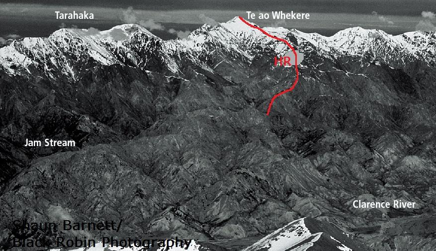
| HR | HRHaycock Ridge | 0m | |||||
|
A remote and very long route from the Waiau Toa Clarence valley. The start of the ridge at Haycock Saddle can be reached in two ways. One is from the end of the 4WD track at Stony Flat on the south bank of the Waiau Toa Clarence River (55 km from Kahutara Bridge on the Inland Kaikoura Road). The alternative is from the lower Waiau Toa Clarence, via George Saddle and then up Jam Stream. A rocky tower at 2130m is the main obstacle.
|
|||||||
Images
Shaun Barnett/ Black Robin Photograhy.

