Highest peak on the Seaward Kaikoura Range, Manakau is a major climb with a large height gain. In summer it is barren, hot and dry, in winter a long snow climb during short daylight hours. In fine weather the views are magnificent. The first ascent is thought to be by James Ingram in 1874.
Routes
| Reference | Title | Grade | Length | Pro | Quality | Alert | Operations |
|---|---|---|---|---|---|---|---|
| Via Uwerau | |||||||
|
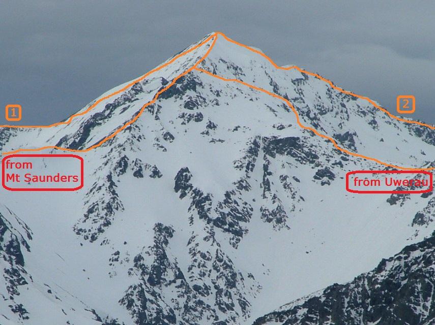
Continuing to Manakau from Uwerau is straightforward. |
|||||||
| East Face | 1800m | ||||||
|
The East Face has been climbed in spring conditions. This is steep and rugged terrain, accessed from the Hāpuku River and guarded by a gorge and waterfalls in Stace Creek.
|
|||||||
| 2 | 2Surveyor Spur Route, II,1+ | II,1+ | 0m | ||||
|
Surveyor Spur is the spur between Mt Stace and the main range. Follow the Hapuku River north branch, now choked with shingle after the 2016 earthquake, until the river swings northeast below Stace Saddle. Further upstream, the old Barratts Hut and bivvy are buried under a large landslip, which has also destroyed an alternative route onto the spur. The summit is an 1850m height gain, so it’s best to camp higher if possible. Stace Saddle (1045m) is easily reached, then follow the spur. The first few hundred metres above the saddle has many tension cracks about 0.5m deep. Fine in daylight but easy to miss by head torch, and not good in wet conditions. There is a good campsite near some large boulders at about 1940m, and in winter and spring there will usually be snow hereabouts. Elsewhere the spur is waterless. Angle up easy slopes to an obvious dip in the main range. In summer it may be necessary to camp in the Stace Creek basin below this dip. Continue along the ridge crest, which steepens beyond a shallow saddle, and bypassing some gendarmes on the north side. Inexperienced parties may prefer a rope here. The traverse to Uwerau is generally straightforward and especially satisfying.
|
|||||||
| Surveyor Spur alternative | 1800m |
|
|||||
|
Access to an alternative route onto Surveyor Spur, starting from O31 659 850 / BT27 559 234, appears no longer possible after the 2016 earthquake. The route was as follows: At a large cairn before the first major tributary on the true right, look for a plastic road marker pole. Initially follow through fern, then move left onto a steep open slope with tussock and scrub. Keep left of all major slips. From a small grass terrace, climb through alpine shrubs, lightly cut. Occasional poles mark the route, however most are not visible from above, hence this route is difficult to follow as a descent, especially if snow covered in the alpine scrub section. Then follow a narrowing ridge. At about 1300m is a small open bivvy site (no water). The route meets the main Surveyor Spur just above the 1940m campsite.
|
|||||||
| North Ridge, 3+ | 3+ | 0m | |||||
|
A remote and very long route from the Waiau Toa Clarence valley. The lower part of the ridge – Fidget Spur – can be reached in two ways. One is from the end of the 4WD track at Stony Flat on the south bank of the Waiau Toa Clarence River (55 km from Kahutara Bridge on the Inland Kaikoura Road). The alternative is from the lower Waiau Toa Clarence, via George Saddle and Haycock Saddle and picking up an old overgrown pack route which sidles westwards and descends to Fidget Stream. Gain the ridge on the true left of Fidget Stream by any convenient side spur. Abseil into the crux, an 80m deep notch. Continue climbing on solid rock till a second 25m deep notch is reached, abseil into this, and then easier ground to the summit.
|
|||||||
| 1 | 1Dubious Stream Route | 0m | |||||
|
A very remote route. Dubious Stream can be reached from the lower Waiau Toa Clarence via George Saddle, Haycock Saddle to Fidget Stream and then via Spring Gully and Packers Stream, or else by the 4WD track on the south bank of the Waiau Toa Clarence River to Goose Flat (50 km from Kahutara Bridge on the Inland Kaikoura Road). A high scree basin north-west of Manakau can be reached via a main eastern tributary of Dubious Stream just upstream of Lacebark Stream.
|
|||||||
photo Clayton Garbes