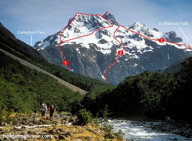
Carrington Pk

Type
Altitude
2010m
Part of

Carrington Pk is an attractive peak seen from near the junction of the Waimakariri and White Rivers. It is a good climb from Waimakariri Falls Hut.

Image
Lat/lon
-42.91353491,171.47014618, NZ Topo Map
Topo50
BV20 751 477
Accessed from
Add Place Add Route

Routes

Reference Title Grade Length Pro Quality Alert Operations
1 1South West Ridge, II,1 II,1 0m
0

From the Waimakariri valley floor, follow the slope north of Campbell Creek
up to the broad shoulder of the South West Ridge. Traverse it to the top or
sidle across the south-east slopes and gain the ridge immediately below the
peak. The final 100m of this ridge is very loose rock.


  • P1
  • Alpine (Commitment) II
  • Alpine (Technical) 1

2 2North Ridge, II,2 II,2 0m
0

Climbed by following the prominent Y-shaped gully through the bluffs at the
base of the peak some 500m downstream of the Waimakariri Falls. This reaches
the easier slopes below the summit’s North Ridge. The lower bluffs are very
prone to rockfall.


  • P1
  • Alpine (Commitment) II
  • Alpine (Technical) 2

3 3Main Divide Route, I,1 I,1 0m
1.02

Climb to the Main Divide opposite the hut (ascend scree/snow slopes just
north of the small side stream above the hut, then move across sidling true
right and up), and traverse it southwards to the summit. A traverse to Mt
Armstrong is an available option.


  • P1
  • Alpine (Commitment) I
  • Alpine (Technical) 1

 Carrington-Armstrong Traverse, I,1 I,1 0m
0

On a good day this is well worth the effort. Ascend Carrington Pk, then the
skyline traverse is a relatively straightforward affair. Descend easy slopes
off Mt Armstrong to the col west of the rock bluffs.


  • P1
  • Alpine (Commitment) I
  • Alpine (Technical) 1

Comments
UUID
 
1322211e-4e36-430e-872a-c7143248c86e