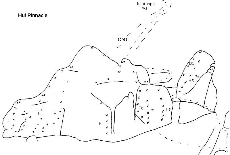
Type
Altitude
980m
Part of
The nearest pinnacle (slab of rock) behind the hut
Approach
Walk uphill through creek, to nearest pinnacle. aproxx 10min from hut.
Routes
| Reference | Title | Grade | Length | Pro | Quality | Alert | Operations |
|---|---|---|---|---|---|---|---|
| s | sStrong, 16 | 16 | 22m | 6 |
|||
|
|||||||
| S | SSilent, 17 | 17 | 22m | 6 |
|||
|
|||||||
| T | TType, 18 | 18 | 23m | 5 |
|||
|
|||||||
| E | EEh, 22 | 22 | 23m | 8 |
|||
|
|||||||
| Fr | FrFrisky, 19 | 19 | 9 |
||||
|
|||||||
| Fo | FoFoxy, 22 | 22 | 9 |
||||
|
|||||||
| Z | ZZesty, 23 | 23 | 25m | 7 |
|||
a fine climb on small holds. |
|||||||
| Fe | FeFeisty, 25 | 25 | 25m | 8 |
|||
another fine climb on small holds. |
|||||||
| BC | BCBart's Climb, 12 | 12 | 5 |
||||
On the slanting pinnacle up to the right. |
|||||||
| HS | HSHigh Step, 20 | 20 | 7 |
||||
|
|||||||
Comments
UUID
069d8803-d196-4ab2-9550-32b9ec6b5d35
