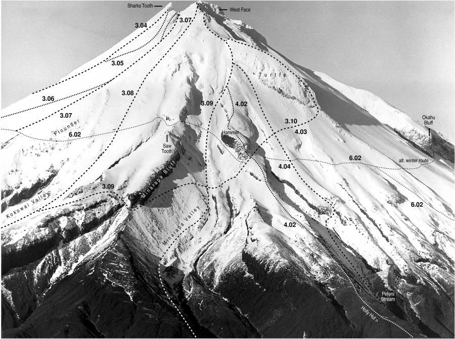
Holly Hut is located on the north side of the mountain.
Accommodation
Holly Hut
Operated by DoC and situated at 3-4 hours from North Egmont via the Razorback, which starts above the Camphouse and then the Holly Hut Track. Holly Hut (1000m) sleeps 38 and is equipped with water, a wood stove for heating, solar powered lighting and mattresses.
Holly Hut is located on Holly flat and is nestled between the mountain, The Dome (1052m) and Ahukawakawa Swamp. Access is via the Holly Hut Track from North Egmont. Holly Hut can be very busy on a summer weekend as it is a favourite resting place for two major walking circuits.
Routes
| Reference | Title | Grade | Length | Pro | Quality | Alert | Operations |
|---|---|---|---|---|---|---|---|
| 4.01 | 4.01Minarapa Valley, 1+ | 1+ | 0m | ||||
From Holly Hut travel back towards North Egmont on the Holly Hut Track to the second streambed, just short of the track junction to Ahukawakawa Swamp. Follow the Minarapa Stream bed and a waterfall at approximately 1350m can be passed by traversing the eastern slopes under the Cake. Climb up the valley, due south, continuing over steepening terrain and short cliff sections, at your choice. Pass just east of the Turtle nose at 2300m on loose ground and continue up the craggy Heberley Ridge to the summit at 2518m. Descent: Via Carrington Ridge route. |
|||||||
| 4.02 | 4.02Carrington Ridge, 1 | 1 | 0m | ||||
Immediately behind Holly Hut, the overgrown route rises steeply up the Carrington Ridge to where the scrub gives way to tussock at around 1440m. Follow the ridge and scramble up the Hammer, 1829m. Pass just east of the Turtle nose at 2300m on loose ground and continue up the craggy Heberley Ridge to the summit at 2518m. Descent: Via Carrington Ridge route. |
|||||||
| 4.03 | 4.03Turtle Traverse, 2 | 2 | 0m | ||||
Immediately behind Holly Hut, the overgrown track rises steeply up the Carrington Ridge to where the scrub gives way to tussock at around 1440m. Follow the ridge and climb up towards the Hammer to 1800m. Traverse under the Hammer and climb south-west to 2000m and to the base of the Turtle at 2000m. Climb the steep buttress and proceed along the exposed arête of the Turtle to the nose at 2316m. Back climb or abseil the 10m off the nose and continue direct to the summit at 2518m via the craggy Heberley Ridge. Descent: Via Carrington Ridge route. |
|||||||
| 4.04 | 4.04Peters Stream, 1+ | 1+ | 0m | ||||
From Holly Hut travel west along the Around the Mountain Circuit towards Kahui Hut and descend into the first stream valley at 900m. Follow the Peters Stream (the mountain branch of Stony River) under Hook Hill and proceed up the steepening valley. Pass just east of the Turtle nose at 2300m on loose ground and continue up the craggy Heberley Ridge to the summit at 2518m. Descent: Via Carrington Ridge route. |
|||||||
