This would perhaps be Christchurch's best crag, if it were next to the road on the Port Hills. But it's not. Mt Bradley (formerly Mount Herbert) is the hill south of Lyttelton Harbour, and the second highest point on Banks Peninsula. The cliffs are near the summit on the north side, overlooking the harbour. It's a long walk (2 hrs), but the excellence of the climbing has made Mt. Bradley an important crag. The cliff is steep and the rock smooth and generally solid. The routes mostly follow obvious cracks so jamming is an essential technique.
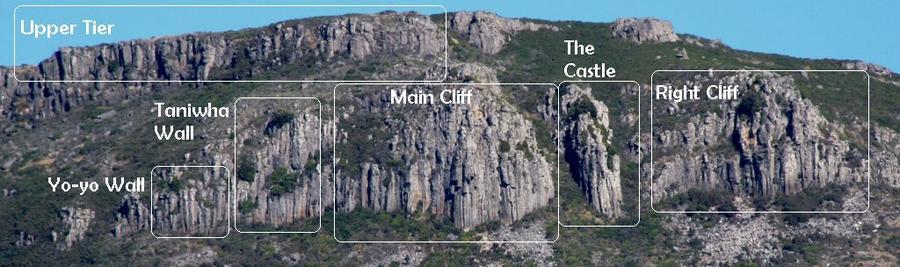
There are four separate cliffs: the Main Cliff, which is the lefthand part of the lower tier, the Right Cliff to the R; the small Castle Cliff between the lat ter two; and the Upper Tier, which is immediately below the summit plateau. The cliff has little shelter, but is very sunny and is best avoided on a hot summer day. Drying is relatively slow.
ACCESS NOTE: as of 2022, land ownership of the Mt Bradley crag has been transferred to the Te Ahu Pātiki Charitable Trust. The trust aims to preserve the ecological and recreational values of the Mt Herbert and Mt Bradley areas. For the time being, climbing remains permitted, but the trust has requested advice regarding an appropriate long-term plan for the crag.
Park at Orton Bradley Park ($10 per car per day) and follow the main track up the valley until you reach a 'Te Ahu Patiki' sign and signs leading to Packhorse Hut. Follow this wide farm track steeply up a spur, with a couple of gates and marker poles before sidling the 'Faulkner Track' until you are directly below the Main Wall (White Wizard area). Best access to the crag is by picking the least scrubby line through grassland then boulderfields. Unfortunately for the native scrub but fortunately for the climber, pig damage (2024) has greatly improved the direct line to the boulder field with minimal scrub bashing required. Otherwise, thick gorse and native scrub regeneration in recent years has made access difficult to all but the Main Wall and immediate surrounds.
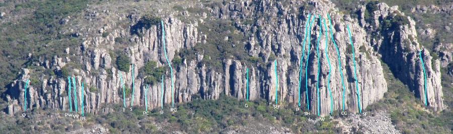
The Main Cliff has recently been equipped with modern DBAs enabling easy descent with a single 60 m rope. There are DBAs at the top of the good climbing (25-30 m mark) on lovely belay ledges on Son of Hangman and nearby on White Wizard (on the same ledge system). An additional DBA at the very top of the cliff (if you are inclined to an alpine-esque adventure through the deteriorating rock) means you can now top out on any route and abseil easily to the White Wizard DBA (watch for choss in the gully). The 'easy descent gully' referenced in older guidebooks and beta is now a serious gorse and scrub bash and no longer a good descent route. In addition, the gully and its vegetated walls are home to subalpine vegetation that is extremely rare on Banks Peninsula and must be treated with care.
Some of the smaller sectors of the crag are now essentially inaccessible due to gorse. In addition, many of the older less frequented crack routes now contain nationally or regionally rare plant species that are elsewhere falling victim to the gorse. In this context, excavation of plants from cracks to enable an occasional visitor to climb an old previously ascended route is hardly justified (and unlikely to endear climbers to the new land managers). Climbs in the classic White Wizard area remain generally clean and excellent; this area is the logical place for climbing to continue.
Places
Images


Access is now overall quite easy thanks to the new direct track from the valley in Orton Bradley (created by Te Ahu Patiki in 2022) and pig damage allowing easy access through the scrub. DBAs have recently been added to enable much easier descents without leaving tat or bashing down the steep gully
Access to the crag is best gained from the farm track just north (and about 150m below; 15min). It involves a bit of scrub bashing and it is best to head for the boulders at the bottom of the main wall. The farm track continues to Packhorse hut (30min).
Topo Added
child change