Ferintosh Pk

(5 routes)

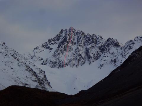
Ferintosh Peak is the most aesthetic peak in the Ben Ohau Range when viewed from the east. Close scrutiny reveals that Glentanner Peak is tucked behind and slightly right of Ferintosh Peak.

Type: 
Mountain
Altitude: 
2497m
Lat/Lon: 
-43.912600000000, 170.027800000000
NZMS260: 
H37 713 952
Topo50: 
BY15 614 335
@@@@@@
Reference Title Grade Length Quality Bolts Gone Natural pro Link to edit content
South Ridge II 2
0
From the head of the north branch of Whale Stream, scramble onto the Ben Ohau divide south of Ferintosh Peak, and traverse north to the summit sticking to the Dobson side of the ridge.
Norman Hardie, 1948
Fluke IV 4 14 450m
1.02
Take the ramp on the left centre of the overhanging face, climb under a chockstone to reach easier ground, then follow the central rib on good quality rock to the summit. Some level sections en route. Descent is via the South Ridge.
Ross Cullen, Bill McLeod, January 1996
Dare Route IV 5 WI4 M4 450m
0
Start up steep ice through the lower rock band, slightly right of centre, before following a vague gully system to finish just right of the crest of the main buttress.
Ben Dare, 8 July 2014
Chance III 4 14 350m
0
3 1
Follow the next major rib right of Fluke. Scramble moraines and snow remnants up towards the base of the peak, with a few steps across Firn snow to the base of the central buttress of the rib. Climb loose rock for the lower/steeper half, following weaknesses close to the crest of the rib, then on quality rock thereafter. Round first tower on left, second on right. From the top, traverse across several towers along the ridge to the summit. On FA, 1 hr 25 for Chance, plus 25mins to summit; then descent was circuitous, made via the great ridge to Glentanner peak and down Twin Stream.
Ruari Macfarlane, February 2021
South West Face
0
No recorded ascent, but Stewart Stream provides good access to the south-west face.
Attribution: 
http://alpineteam.co.nz/blog
UUID: 
df3d9146-102f-4255-8878-74e16f75d065