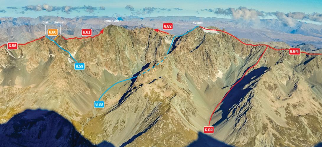
Type Mountain Altitude 2614m Part of Liebig Range Map Lat/lon-43.582115,170.402721, NZ Topo Map Accessed from Murchison Glacier Godley River Image Caption Liebig Range, Mt Olaf to Mt Hutton, March 2016 Rights credit Rob Frost/Subalpine Photography Routes Reference Title Grade Length Pro Quality Alert Operations 6.58 6.58North Ridge, III,2+ III,2+ 0m 0 Rate From Godley Pass. Consists of scrambling on poor rock for quite a long way. P1 Alpine (Commitment) III Alpine (Technical) 2+ 6.59 6.59South Ridge, II,2+ II,2+ 0m 0 Rate From the Murchison Glacier, climb up into the basin beneath Mt Ronald Adair, then climb rock and scree (and snow, depending on the season) to gain the Olaf – Kenneth Col. From the col, climb the ridge of poor rock to the summit. P1 Alpine (Commitment) II Alpine (Technical) 2+ Add Place Add Route Log in to post comments Comments This place appears in Aoraki Tai Poutini: a guide for mountaineers, 2018Buy this guidebook Attribution ATP 2018 (Rob Frost) UUID ba6f723a-3c2c-4525-98c0-b1d6c12ddb78
Image Caption Liebig Range, Mt Olaf to Mt Hutton, March 2016 Rights credit Rob Frost/Subalpine Photography